Pitney Bowes MapInfo Professional User Manual
Page 265
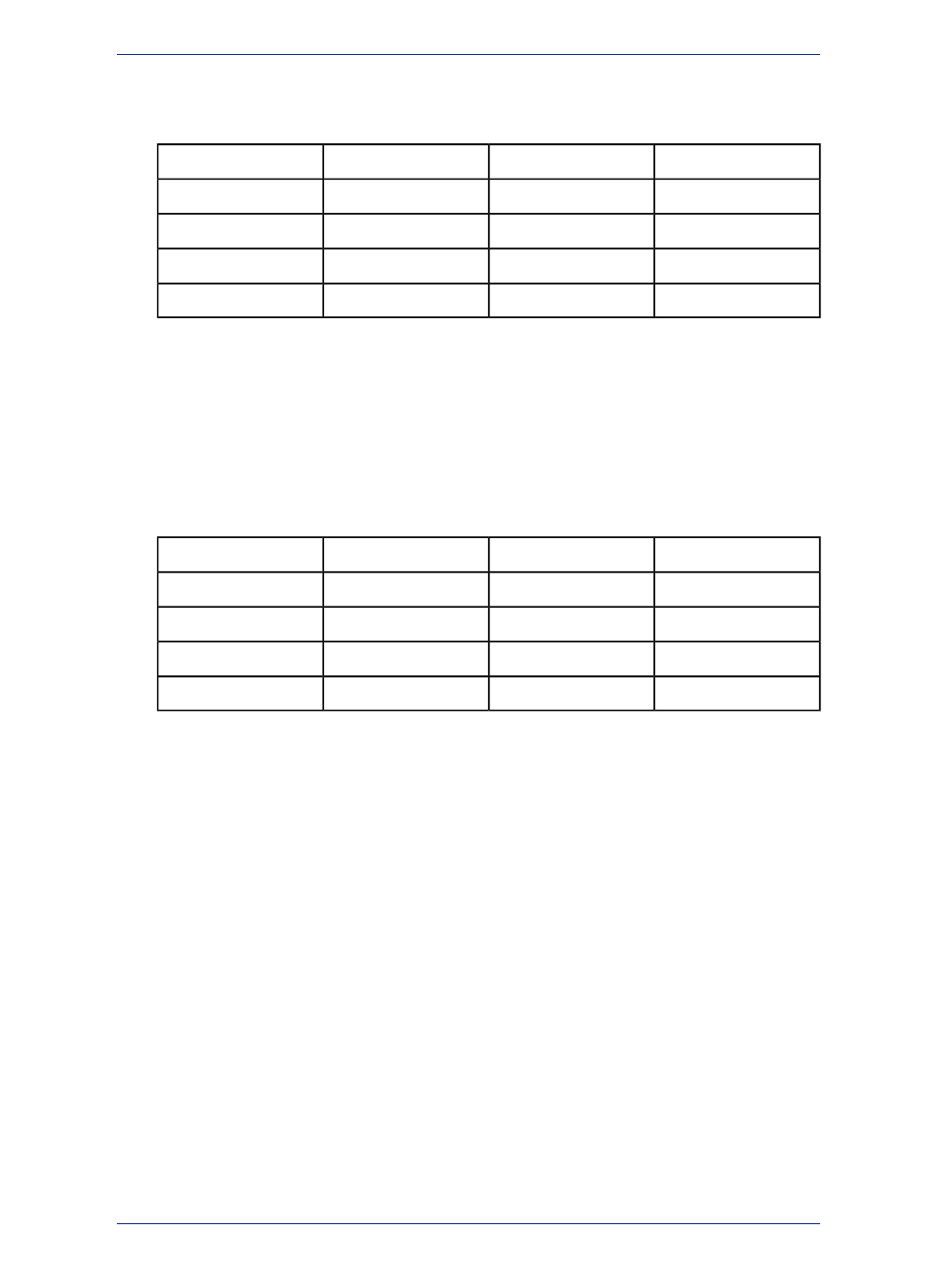
When using Equal Count (or any other range method), it's important to watch out for any extreme data
values that might affect your thematic map (in statistics, these values are referred to as outliers). For
example, if you tell MapInfo Professional to shade according to Equal Count with this database:
7000
Andrea
5000
John
5500
Kyle
6000
Penny
7500
Angela
4500
Miguel
6000
Elroy
5000
Linda
7000
Mark
100
Ben
Ben and Miguel are grouped in the same range (since they have the two lowest values). This may not
produce the results you want since the value for Ben is so much lower than any of the other values.
Equal Ranges divides records across ranges of equal size. For example, you have a field in your table
with data values ranging from 1 to 100. You want to create a thematic map with four equal size ranges.
MapInfo Professional produces ranges 1-25, 25-50, 50-75, and 75-100. (Since ranges use "=>" and
"<=", they need to overlap.)
Keep in mind that MapInfo Professional may create ranges with no data records, depending on the
distribution of your data. For example, if you tell MapInfo Professional to shade the following database
according to Equal Ranges:
90
Andrea
100
John
1
Kyle
6
Penny
92
Angela
4
Miguel
89
Elroy
95
Linda
10
Mark
10
Ben
MapInfo Professional creates four ranges (1-25, 25-50, 50-75, and 75-100). Notice, however, that only
two of those ranges (1-25 and 75-100) actually contain records.
Natural Break and Quantile are two ways to show data that is not evenly distributed.
Natural Break creates ranges according to an algorithm that uses the average of each range to distribute
the data more evenly across the ranges. It distributes the values so that the average of each range is
as close as possible to each of the range values in that range. This ensures that the ranges are
well-represented by their averages, and that data values within each of the ranges are fairly close
together. MapInfo Professional bases its Natural Break algorithm on the procedure described by Jenks
and Caspall in their article "Error on Choroplethic Maps: Definition, Measurement, Reduction" from the
Annals of American Geographers, June, 1971.
Quantiling enables you to build ranges that determine the distribution of a thematic variable across a
segment of your data. For example, you can quantile state population by urban population to illustrate
how urban population is distributed across the United States. Your map legend will not indicate that you
have used Quantile to build your ranges. You can customize the map legend so that it shows which field
you used to quantile the table.
When you create ranges using Standard Deviation, the middle range breaks at the mean of your values,
and the ranges above and below the middle range are one standard deviation above or below the mean.
You can also define your own ranges using Custom.
The Help System contains these related topics:
• Creating a Map by a Range of Values
• Customizing a Range Map
265
MapInfo Professional User Guide
Chapter 10: Creating Thematic and Other Themed Maps