Figure of merit, Failure code, Solid earth tides – NavCom Sapphire Rev.J User Manual
Page 349: Table 182: failure code
Sapphire Technical Reference Manual Rev. J
349
2.91.10
Figure of Merit
This value represents the estimated position and clock errors, valid only when the
navigation engine has found a valid solution. The code creates the FOM by using the 2D
RMS horizontal error estimate, as shown here, where [0] is North and [2] is Up:
fom = sqrt(R->covariance[0] + R->covariance[2]) * 100;
This creates a value that is normalized to a value from 1-255, where the lower the
number, the lower the error, and the better the solution.
2.91.11
Failure Code
While the code does not have a valid solution, it makes available the information in the
following table to describe the reason why there is not yet a solution. Code 1 means
there is a solution; all of the others represent a reason there is not one.
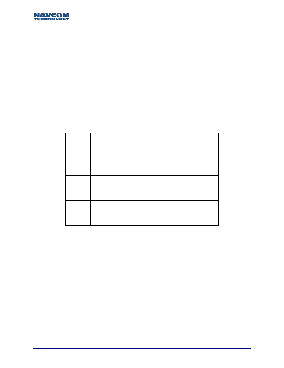
Table 182: Failure Code
Code
Description
1
Navigation solution available
2
Too few measurements for navigation initialization
3
Initialization failed
4
Navigation initialization completing
5
Too few measurements for navigation
6
Navigation PDOP too high
7
No velocity solution
8
Navigation update too large
9
Export height/velocity limits exceeded
10
Available navigation modes are disabled or not authorized
2.91.12
Solid Earth Tides
As the earth rotates within the gravitational fields of the Sun and Moon, it deforms
because it has a certain degree of elasticity. These deformations are called solid earth
tides or terrestrial tides. The amplitude of terrestrial tides can be as large as 55 cm in the
vertical at the equator (15 cm of which are due to the Sun), and they are nearly in phase
with the Moon. Solid earth tides can be accurately predicted (within a few centimeters)
with a model that takes position on the earth, date and time as its inputs and produces a
three dimensional deformation vector (North, East and vertical).
The StarFire correction processing hubs combine data from a global network of
reference stations. Solid earth tides are estimated for the location of each reference
station in real time, and are used to adjust the reference station locations utilize in the
computation of the StarFire global satellite clock and orbit corrections. Likewise, when
the receiver is operating in StarFire differential mode using global RTG corrections, the
solid earth tide is estimated in real time for the navigation position and used to correct
the latitude, longitude and height reported in the PVT1B message. The values of the 3D
deformation vector are reported in the PVT1B message as floating point values scaled in
meters.