Reference line results, Reference line – Leica Geosystems TPS1100 Professional Series - Reference Manual User Manual
Page 70
70
TPS1100 - Appl. Prog. Ref. Manual 2.2.0en
Reference Line
∆
∆
∆
∆
∆
Ht
Edit Elev.= OFF: Height difference
along the vertical between the target
point and the reference elevation.
Edit Elev. = ON: Height difference
between entered and measured elev.
∆∆∆∆∆
Perp.Dist
(only for configuration Ref.Elev. =
Baseline. Not available for Arc)
Height difference between the target
point and the reference elevation,
perpendicular to the reference
elevation.
∆∆∆∆∆
Spat.Dist
(only for configuration Ref.Elev. =
Baseline. Not available for Arc)
Line Offset along the reference
elevation.
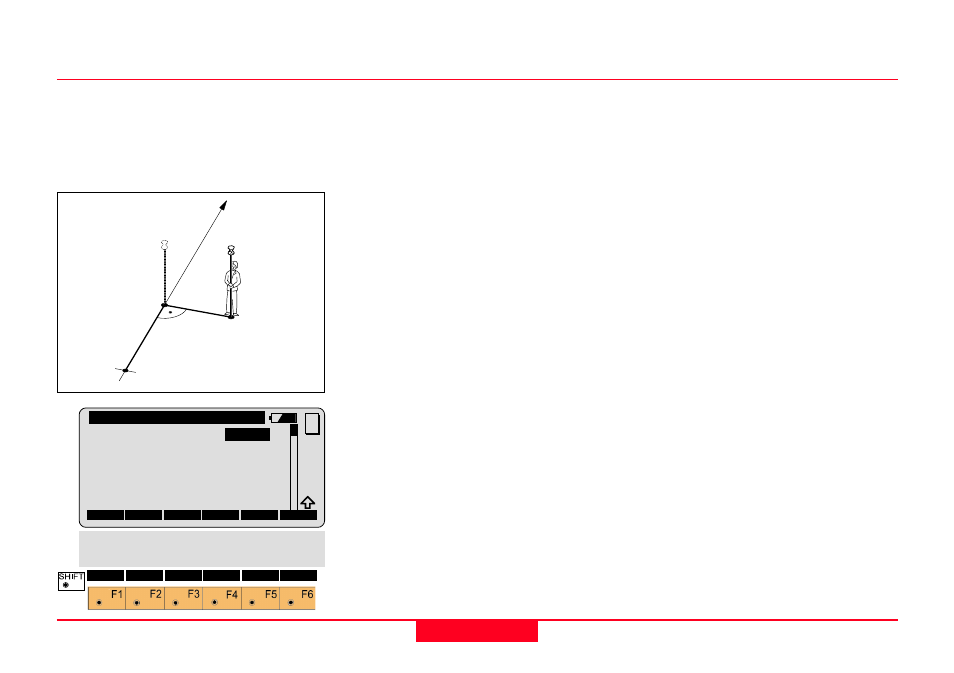
The “Reference Line Results” dialog
displays the data of the measured
point referring to the reference line,
as shown below:
Point Id
The point number of the stakeout
point.
∆
∆
∆
∆
∆
Offset
Perpendicular Offset:
∆
Offset+: To the right of the
reference
∆
Offset-: To the left of the reference
∆
∆
∆
∆
∆
Line (or
∆∆∆∆∆
Arc)
Line offset from the first Ref. Point
∆
Line+: in the line direction
∆
Line-: in the opposite direction of
the line.
∆∆∆∆∆
L from P2 (or
∆∆∆∆∆
A from P2)
(only for configuration Line/
α
= OFF)
Line offset from the 2nd Ref. Point
∆
L P2+: in the direction of the line
∆
L P2-: in the opposite direction of
the line (P2 -> P1).
Reference Line Results
1
100pr20
∆
Offset +
Reference Line
Measured
Point
1st Ref. Point
∆
Line +
REFL\Reference Line Results
Point Id
:
12
Refl. Ht. :
1.530
∆∆∆∆∆
Offset
:
0.020 m
∆∆∆∆∆
Line
:
1.468 m
∆∆∆∆∆
Ht
:
-0.558 m
∆∆∆∆∆
Perp.Dist:
0.039 m
ALL
DIST
REC
DONE
MC
∆∆∆∆∆
L P2
QUIT
∆∆∆∆∆
Spat.Dist:
3.020 m
Elevation :
103.020 m