Define local plane, Results dialog – Leica Geosystems TPS1100 Professional Series - Reference Manual User Manual
Page 260
260
TPS1100 - Appl. Prog. Ref. Manual 2.2.0en
Define Local Plane
Calculates the plane parameters as
well as standard deviation of the
adjusted plane (for more than 3
points). Coordinate entry for origin of
local system.
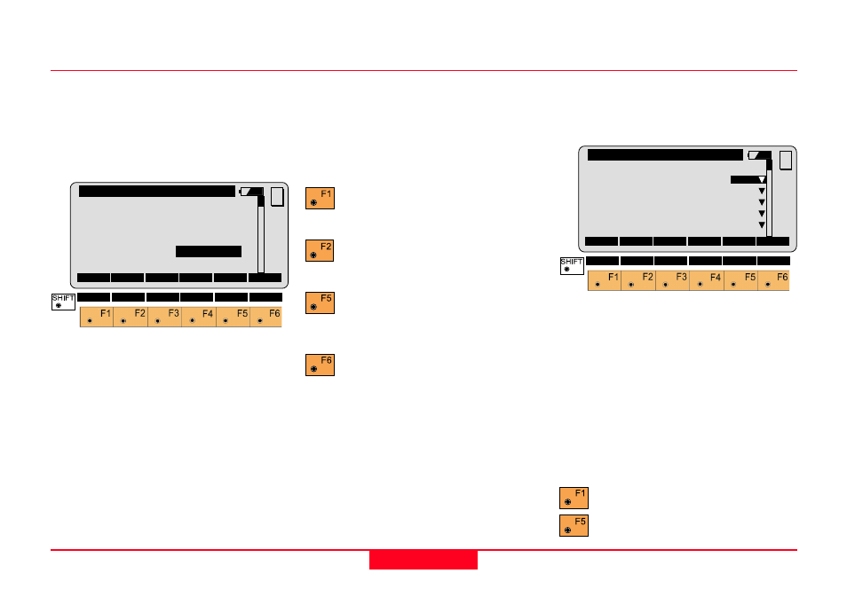
REFP\ Define Local Plane
No. of Pts:
4
s0
:
0.020 m
Enter local coord of 1st Pt.
X-Coord.
:
0.000
m
Z-Coord.
:
0.000 m
MC
CONT ADD P
MORE
NEW
No. of Pts.
Number of points used for plane
calculation.
s0
Standard deviation of the plane.
X-Coord
Enter local X-coord of origin. The
origin is defined as the projection of
the first measured point onto the
calculated plane (see graphics).
Z-Coord
Enter local Z-coord. of origin. The
origin is defined as the projection of
the first measured point onto the
calculated plane (see graphics).
Set origin and continue to
offset dialog.
Measure additional points to
define plane.
Show the results of each
definition point. (See "Results"
dialog)
Define new plane.
Results Dialog
Displays the perpendicular deviation
of each defining point from the plane
(only if 4 or more points are used).
REFP\ Results
PtId
∆∆∆∆∆
d (m)
Sts
100:
0.001
ON
101:
-0.002
ON
102:
0.002
ON
103:
-0.263
OFF
104:
-0.001
ON
MC
RECLC
DEL
Pt.Id
Displays Pt.Id of defining points.
∆∆∆∆∆
d (m)
Deviation of point from plane.
Sts
Point status can be ON/OFF. If point
is off, it is not included in the
calculation.
Recalculate the plane.
Delete point.