Data formats, Dxf-format, Monitoring – Leica Geosystems TPS1100 Professional Series - Reference Manual User Manual
Page 268
268
TPS1100 - Appl. Prog. Ref. Manual 2.2.0en
Monitoring
Data for DTM-Stakeout may be
prepared in one of two formats.
These are AutoCAD DXF or the
standard Leica GSI format. The files
must be stored on the PC-card.
Files may be named with any valid
DOS name and either a *.dxf or *.gsi
extension.
Data Formats
• AutoCAD DXF - Format
DTM triangles are imported as 3DFACE entities from a DXF file. Properties,
Layers, etc. may be in the DXF file but are ignored by the DTM-Stakeout
application. The completion of the polygon by repeating the first or last point
is required by AutoCAD but not by the application. The format is as follows:
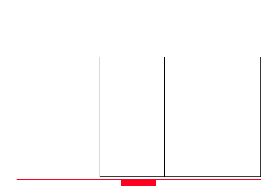
DXF-Format
0
Start of record.
3DFACE
Record is a 3D face entity.
TRIANGLE
3D face type.
10
X coordinate, first point.
723573.984000
X value.
20
Y coordinate, first point.
7663192.178000
Y value.
30
Z coordinate, first point.
23.383000
Z value.
11
X coordinate, second point.
723576.998000
X value.
21
Y coordinate, second point.
7663191.120000
Y value.
31
Z coordinate, second point.
23.029000
Z value.
12
X coordinate, third point.
723572.684000
X value.
22
Y cordinate, third point.
7663189.966000
Y value.
32
Z coordinate, third point.
24629.000
Z value.
13
X coordinate, third point.
723572.684000
X value.
23
Y cordinate, third point.
7663189.966000
Y value.
33
Z coordinate, third point.
24629.000
Z value.
0
End of record.