Horizontal offset stake out summary, Select alignment files, Set offset value and select point to stakeout – Leica Geosystems TPS1100 Professional Series - Reference Manual User Manual
Page 222: Road
222
TPS1100 - Appl. Prog. Ref. Manual 2.2.0en
Road+
Set offset value and select point to stakeout
To select the template point
to stake (back of curb, edge
of pavement etc.):
The "Cross Sections" options display
appears.
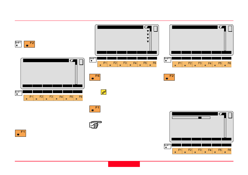
Horizontal Offset Stake Out Summary
Start "ROAD+" from the program
menu.
Start the "Configuration-
Editor" from the "Select
Aln Files" dialog.
QUIT
Road+\
Configuration
Begin Sta.:
0.000
End Sta.:
89.270
Sta. Incrm:
10.000 m
Ht. Shift :
0.000 m
Deflct.Tol:
0°00'20''
Sta. Tol:
0.010 m
MC
CONT
DEFLT INFO
Enter the beginning and ending
station (chainage), the station
(chainage) increment and so forth.
Make all entries.
Returns to the "Select Aln
Files" display.
Select Alignment Files
QUIT
Road+\
Select Aln Files
Aln. Dir
:
...\GSI\
Horiz.Aln.:
ALNOFFICE
Vert. Aln.:
PRFOFFICE
Cross Secs:
CRSOFFICE
MC
CONT
Select the alignment files.
Place the cursor on each file type,
press
and pick the file from the
displayed list. Select the files.
To accept the specified files
and check them for errors.
A Horizontal Alignment
File must be selected.
|<-- -->|
QUIT
Road+\ Station & Offset
Station
:
0.000 m
Element
:
POB
H Offset
:
0.000 m
V Offset
:
0.000 m
MC
CONT
XSEC
<-S
S->
STA?
PLOT
QUIT
Road+\
Cross Sections
1R
Station
:
25.000
Template
:
+000tutor
∆∆∆∆∆
CL Offset:
1.500 m
∆∆∆∆∆
CL Ht.Dif:
-0.030 m
Stake Offs:
0.600 m
MC
CONT CATCH
<-- CENTR
-->