More information, Free station – Leica Geosystems TPS1100 Professional Series - Reference Manual User Manual
Page 59
59
TPS1100 - Appl. Prog. Ref. Manual 2.2.0en
Free Station
Display the residuals of individual
measurements. You can also disable
points from the calculation of position
or height as well as delete erroneous
measured points.
More Information
Point Id
The target point number.
Pt. Status
ON
Measurements to target point
used for calculation.
Ignore Elev.
Target point elevation disabled:
measurements for elevation
determination not used in
calculation.
OFF Target point disabled:
measurements to point NOT
used for calculation.
Error Flag
Identified erroneous measurements.
Possible values are:
NONE
measurement is OK
HZ
horizontal angle error
DIST
distance error
HT
height difference error
The flags may also be combined, i.e.
DIST + HZ
9/10
Sequence number of the current
point and total number of points in
the measurement set. The scroll bar
shows the sequential position of the
measurements, graphically.
∆
∆
∆
∆
∆
Hz.
Difference between calculated and
measured Hz. angle
∆
∆
∆
∆
∆
Dist
Difference between calculated and
measured distance
∆
∆
∆
∆
∆
Ht
Difference between calculated and
measured height
Refl. Ht.
Reflector height used for that target
point
East, North, Elevation
Target coordinates used.
Recalculate the result.
Scroll to the measurements
of the previous point.
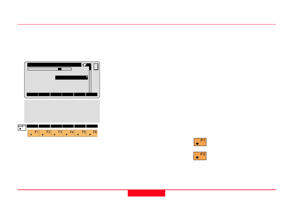
FreSt\
More Info
9/10
Point Id
:
12
Pt. Status:
ON
Error Flag:
NONE
∆∆∆∆∆
Hz
:
0°00'03''
∆∆∆∆∆
Dist.
:
0.050 m
MC
QUIT
RECLC <--
-->
MEAS
DEL
BACK
∆∆∆∆∆
Ht.
:
0.020 m
Refl. Ht. :
1.555 m
East
:
991.427 m
North
:
1995.162 m
Elevation :
402.466 m