Base location – Ag Leader GeoSteer Operation Manual User Manual
Page 114
RTK
100
GeoSteer System
• Elevation – This is the angle the GPS satellite is above the horizon (Higher is higher in the sky).
• L1 (Pink) –This is the Signal to Noise Ratio for the L1 Band (Higher is better).
• L2 (Red) –This is the Signal to Noise Ration for the L2 Band (Higher is better).
Base Location
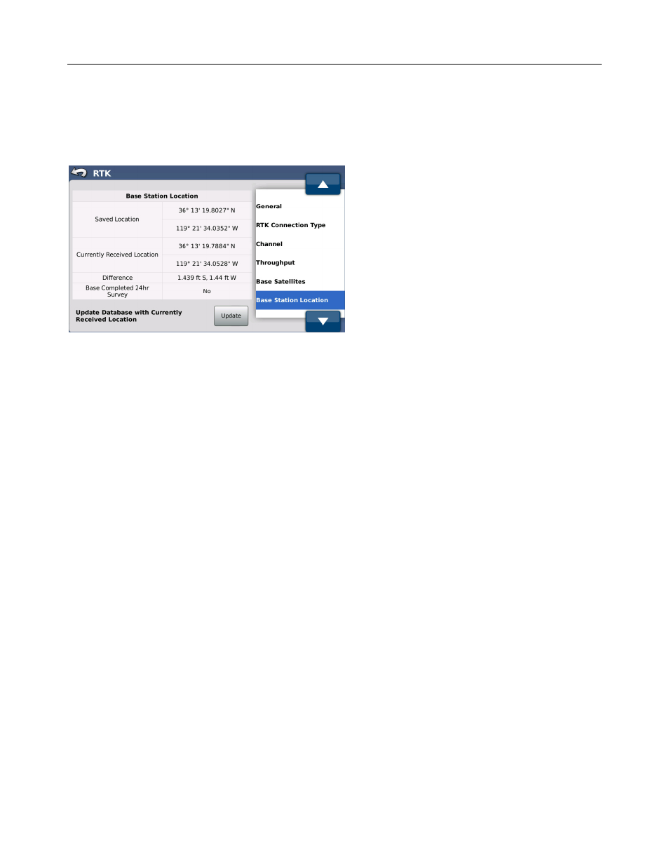
Figure 4-13 Base Station Location
The Base Station Location screen displays information about the Base Station that the GeoSteer is referencing. For a GeoSteer
to share data with 3
rd
party devices, other software, and other GeoSteer systems, it requires that the active Base Station has a
surveyed position. This position is used to calculate the relative latitude and longitude positions that are used for guidance lines
and data collection. This screen makes it easy to determine if the active Base Station has been surveyed in and, if not, allows
the user to fix that problem.
Base Stations transmit their location and whether they have been surveyed to the GeoSteer units. If the Base Station is
surveyed in, the position that is transmitted will always be the same. If it is not surveyed in, the position transmitted will
always be changing slightly as the calculated position drifts. The first time a GeoSteer detects an active Base Station, it adds
the location that was transmitted from the active Base Station to an internal database stored on the GeoSteer unit whether it was
surveyed or not. This internal GeoSteer database stores the location of all Base Stations it has ever referenced, both surveyed
and unsurveyed.
When a GeoSteer powers up and starts communicating with a Base Station, it first compares the list of internal Base Stations
locations with the location of the active Base Station that is transmitting. If it finds a Base Station location in its internal list
within 32.8 feet (10.0 m) of the location being transmitted, the GeoSteer assumes that the Base Station transmitting is the same
one stored in the database. If it does not find a Base Station within that limit, it creates a new internal Base Station in its
database with the new information.
If the system is working with a surveyed Base Station, the GeoSteer will always reference the same Base Station because the
location being transmitted will always be the same as the one stored on the GeoSteer. If the Base Station is not surveyed in,
comparing the internal list to the zone around the actual location allows the GeoSteer to make a educated guess as to which
stored Base Station on its list is the same as the one that was stored the last time.
So long as the information on the GeoSteer system is not being shared with other devices, the GeoSteer can AutoSteer with an
unsurveyed Base Station. The GeoSteer system will store jobs and A/B lines and will be able to repeat those jobs if the Base
Station’s GPS antenna is not moved and the reference position stored in the GeoSteer is not changed. Though a GeoSteer can
operate in this situation, it is not recommended. If additional systems are added to the fleet in the future, all current jobs and
data will not be compatible or transferable to the new systems.
Because of the limitations of running with an unsurveyed Base Station, it is highly recommended that the user allows the Base
Station to survey in (this takes around 24 hours in most cases). After the Base Station has been surveyed in, the Base Station
Location screen provides a tool to update the stored Base Station to the new surveyed position.