Google Earth User Guide User Manual
Page 89
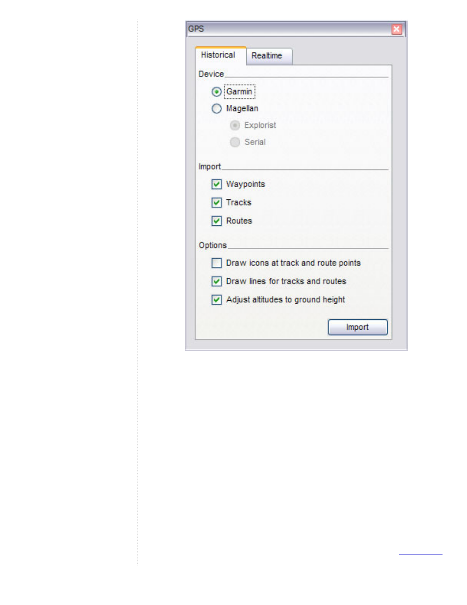
5. Select the correct manufacturer type for your device.
6. Under Import, Select the types of data you want to import.
7. Under Options, choose your drawing preferences. Check Draw icons
at track and route points if you want an icon to be displayed in the 3D
viewer for every track/route point recorded by your GPS device.
Check Draw lines for tracks and routes to draw each GPS track and
route as a solid line.
8. Check the Adjust altitude to ground height check box to adjust all
recorded point to ground level, such as when importing a track taken
on foot, car, or bike. However, if your GPS track was recorded while
hang gliding or flying, make sure this option is not selected so that
your points will appear as above-ground points.
9. Click OK. When your GPS data is finished loading into Google Earth,
a confirmation dialog box appears.
Your data appears in the Places panel with the label Garmin GPS Device or
Magellan GPS Device, depending upon the device used (see
- Message Archiving Administration Guide (79 pages)
- Apps Technical Transition Guide For Business, Education, and Government (56 pages)
- Message Continuity User Guide (5 pages)
- Search Appliance User Experience Guide (31 pages)
- Apps Directory Sync Administration Guide (146 pages)
- Android 2.3.4 Users Guide (384 pages)
- Android 3.0 Users Guide (140 pages)
- Galaxy Nexus Android mobile technology platform 4.0 Users Guide (107 pages)
- Anywhere+ Deployment Guide V1.0.1 (51 pages)
- Activation Guide Message Filtering (46 pages)
- DoubleClick Rich Media Guide to Rich Media Innovation (4 pages)
- Remarketing in AdWords Seven-Minute Setup Guide (4 pages)
- Grants Beta A BEGINNERS GUIDE (13 pages)
- Search Appliance OneBox for Enterprise Developers Guide (30 pages)
- Search Appliance Feeds Protocol Developers Guide (45 pages)
- SketchUp: Getting Started (2 pages)
- Agency Product Guide (2 pages)
- Changes to AdWords Reporting A Comprehensive Guide (13 pages)
- Search Appliance Connectors Administration Guide (41 pages)
- Search Appliance Guide to Software Release 7.0 (10 pages)
- DTorial: An interactive tutorial framework for blind users in a Web 2.0 world (14 pages)
- Networking Best Practices for Large Deployments (42 pages)
- Apps Migration for Lotus Notes Installation & Administration Guide (100 pages)
- Understanding Visualization by Understanding Individual Users (5 pages)
- Web Security for Enterprise Administration Guide (83 pages)
- Education – access infrastructure guide (11 pages)
- Message Continuity Setup and Administration Guide (33 pages)
- Search Appliance Getting the Most from Your Google Search Appliance (77 pages)
- Search Appliance Getting the Most from Your Google Search Appliance (82 pages)
- Commerce Search Deployment Guide (29 pages)
- Apps Migration for Microsoft Exchange Administration Guide (78 pages)
- Grants Ongoing Management Guide (26 pages)
- Custom Search Engine (beta) Starter Guide (8 pages)
- Search Appliance Policy ACL API Developers Guide (24 pages)
- PRINCIPLES OF MOBILE SITE DESIGN: DELIGHT USERS AND DRIVE CONVERSIONS (42 pages)
- Search Engine Optimisation Starter Guide (22 pages)
- Website Optimizer v 1.0 The Techie Guide (26 pages)
- Search Appliance Creating the Search Experience (141 pages)
- Apps Security and Compliance Services Web Services Application Programming Interface Guide, Early Access Version 1.5 (70 pages)
- Message Security Batch Reference Guide (561 pages)
- Message Archiving Microsoft Exchange Journaling Configuration Guide For Exchange Server 2007 and 2010 (33 pages)
- Search Appliance Authentication/Authorization for Enterprise SPI Guide (33 pages)
- AdMob Case Study TV Guide Digital (2 pages)
- Apps Connector for BlackBerry Enterprise Server Installation and Administration Guide (70 pages)