Geoidal99 format, Table 3: geoidal99 header format, Table 4: geoidal99 data format (variable length) – NavCom StarUtil-3000 Rev.G User Manual
Page 78: Upload a user-defined geoid height map
StarUtil 3000 User Guide
– Rev G
4-76
GEOIDAL99 Format
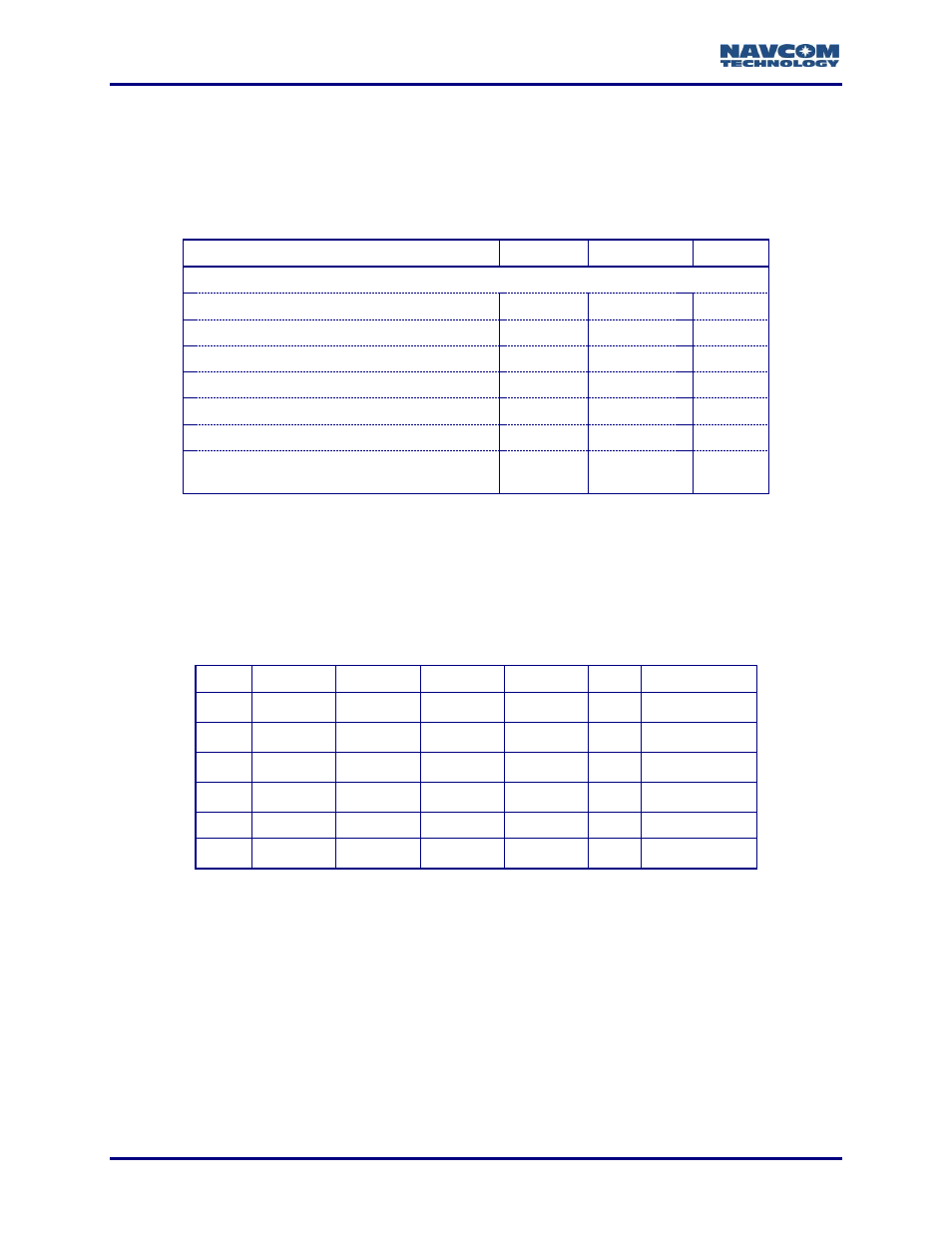
The GEOIDAL99 database file must be a binary file. It has a header plus a data section,
described below.
Table
3
: GEOIDAL99 Header Format
Data Item
Data Type
Units
Bytes
Header
SLAT
– Southernmost latitude
R64
Degrees
8
WLON
– Westernmost longitude
R64
Degrees
8
DLAT
– Distance interval in latitude
R64
Degrees
8
DLON
– Distance interval in longitude
R64
Degrees
8
NLAT
– Number of rows of latitude
U32
4
NLON
– Number of columns of longitude
U32
4
IKIND
– Data type
The value always should be 1 (=> real *4)
U32
4
The data section of the GEOIDAL99 database file follows immediately after the header. Table
displays the format, in which
“a” represents a R32 Data Type, R = Row and C = Column. For
example,
“a
R3C2
” = 4 bytes (real number) of data at Latitude Row 3, Longitude Column 2.
The data is variable length. NLAT is the total number of rows. NLON is the total number of
columns. (Table
Table
4
: GEOIDAL99 Data Format (variable length)
1
2
3
4
NLON
1
a
R1C1
a
R1C2
a
R1C3
a
R1C4
…
a
R1CNLON
2
a
R2C1
a
R2C2
a
R2C3
a
R2C4
…
a
R2CNLON
3
a
R3C1
a
R3C2
a
R3C3
a
R3C4
…
a
R3CNLON
4
a
R4C1
a
R4C2
a
R4C3
a
R4C4
…
a
R4CNLON
…
…
…
…
…
NLAT
a
RNLATC1
a
RNLATC2
a
RNLATC3
a
RNLATC4
a
RNLAT/CNLON
The data section is stored in the file beginning with the Westernmost (WLON)/Southernmost
(SLAT) point. In Table
, this is the first point in Row 1:
“a
R1C1
”. Row 1 (row-major) is stored:
“a
R1C1
”, “a
R1C2
”, “a
R1C3
”, “a
R1C4
”, etc. Then Row 2 is stored: “a
R2C1
”, “a
R2C2
”, “a
R2C3
”, “a
R2C4
”, etc.
This is continued sequentially for each row until the Easternmost/Northernmost point,
“a
RNLAT/CNLON
”, is stored. Each row creates a list of 4-byte real values NLON long, with DLON
longitudinal intervals along the row of latitude.