Projections and their parameters – Pitney Bowes MapXtreme User Manual
Page 565
Appendix H: Elements of a Coordinate System
Projections and Their Parameters
MapXtreme v7.1
572
Developer Guide
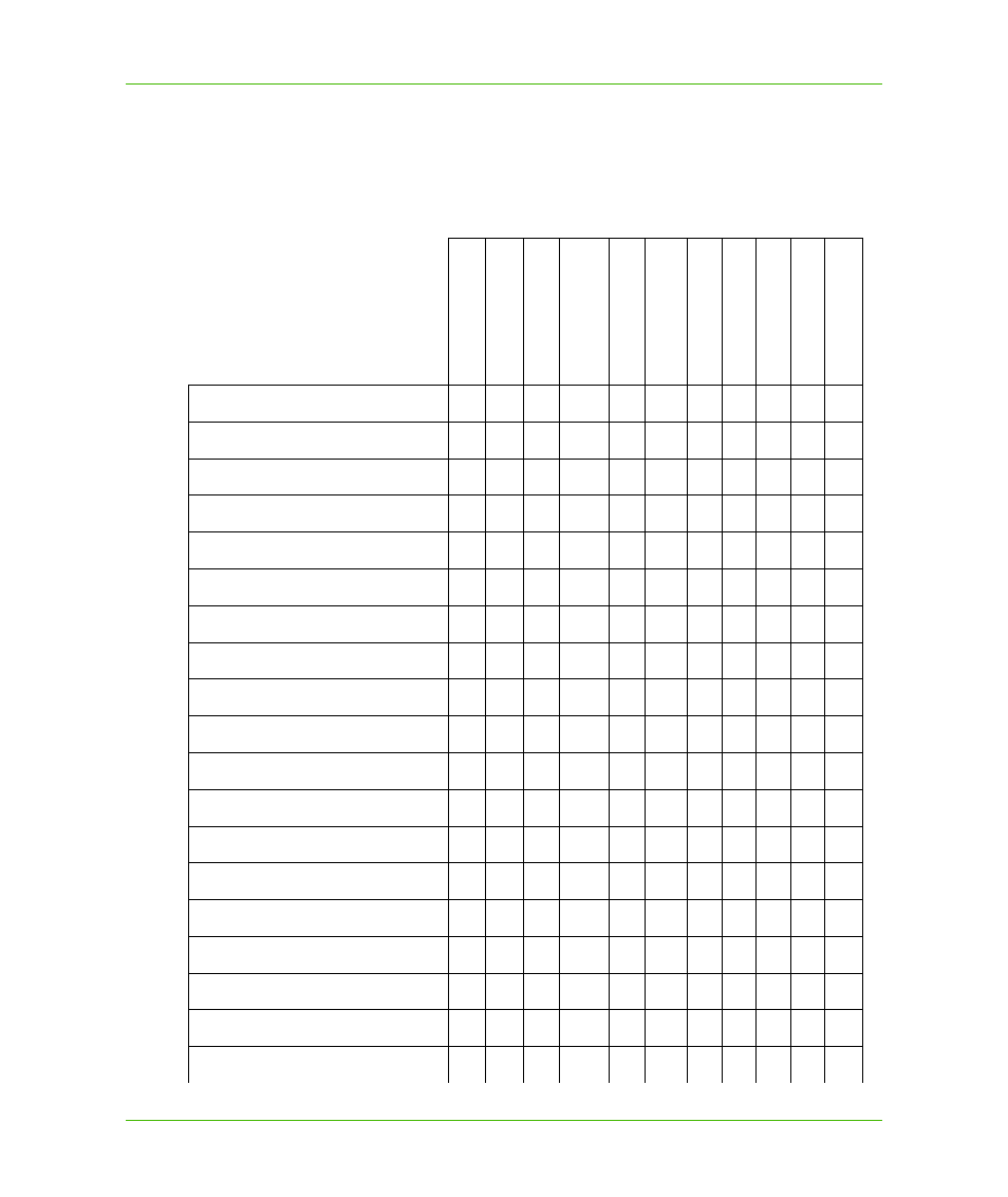
Projections and Their Parameters
The following table indicates the parameters applicable to each projection, which are listed in the
order they appear in the relevant coordinate system lines in the MapInfoCoordinateSystemSet.xml.
The document is located in C:\Program Files\Common Files\MapInfo\MapXtreme\7.x.x.
Da
tu
m
Un
its
Origin
, Lo
ngitud
e
Origin
, La
titud
e
S
ta
nda
rd Pa
ralle
l 1
S
ta
nda
rd Pa
ralle
l 2
Azimuth
Scal
e Factor
False Easting
F
alse No
rthi
ng
Ra
nge
Albers Equal-Area Conic
X
X
X
X
X
X
X
X
Azimuthal Equidistant
X
X
X
X
X
Cassini-Soldner
X
X
X
X
X
X
Cylindrical Equal Area
X
X
X
X
Double Stereographic
X
X
X
X
X
X
X
Eckert IV
X
X
X
Eckert VI
X
X
X
Equidistant Conic
X
X
X
X
X
X
X
X
Gall
X
X
X
Hotine Oblique Mercator
X
X
X
X
X
X
X
X
Lambert Azimuthal Equal-Area
X
X
X
X
X
Lambert Conformal Conic
X
X
X
X
X
X
X
X
Longitude-Latitude
X
Mercator
X
X
X
Miller
X
X
X
Mollweide
X
X
X
New Zealand Map Grid
X
X
X
X
X
X
Polyconic
X
X
X
X
X
X
Regional Mercator
X
X
X
X