Pitney Bowes MapXtreme User Manual
Page 235
Chapter 11: Accessing Data from a DBMS
Adding Rows to the MapInfo_MapCatalog
MapXtreme v7.1
242
Developer Guide
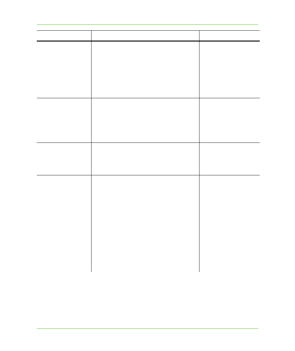
SYMBOL
A MapInfo Symbol clause (if the layer contains only
points); or a Symbol clause followed by a Pen
clause (indicating styles for linear features)
followed by another Pen clause (indicating styles
for the borders of regions) followed by a Brush
clause.
Maps to
MapInfo.Data.GeometryColumn.DefaultStyle
Symbol(35,0,12)
Pen(1,2,0)
Pen(1,2,0)
Brush(2,255,255)
XCOLUMNNAME
For the X/Y mappable tables, specify the name of
the column containing X-coordinates. If there is no
such column (i.e., if this table uses a single spatial
column instead of a pair of X-Y columns) then
specify NO_COLUMN or leave empty.
Maps to MapInfo.Data.SpatialSchemaXY
NO_COLUMN
YCOLUMNNAME
For the X/Y mappable tables, specify the name of
the column containing Y–coordinates, or specify
NO_COLUMN
Maps to MapInfo.Data.SpatialSchemaXY
NO_COLUMN
RENDITIONTYPE
This indicates how the object style information is
applied.
0 – Indicates that all the objects in the table will
have the style specified in the symbol field of the
MapCatalog applied to them. No per-record styles
are in effect. Objects will be read/updated using the
default style for the table.
1 – Indicates that the table uses per-record styles.
The table has a separate column that contains a
MapBasic string representation of the style
information for each object in the table (the same
format that is currently used in the MapCatalog’s
SYMBOL column). The style column in the table is
recorded in RENDITIONCOLUMN.
0 or 1
Column Name
Values to Assign
Examples