Uncorrected barometric altitude (203), Barometric altitude rate (212), Computed airspeed (206) – Honeywell MK VI User Manual
Page 293: Digital data, rs-232, Xpress gps packets id 17: ground speed/track angle
Honeywell
MK VI MK VIII EGPWS Installation Design Guide
Proprietary notice on title page applies
CAGE CODE: 97896
SCALE: NONE
SIZE: A
DWG NO: 060-4314-150
REV:
SHEET
293
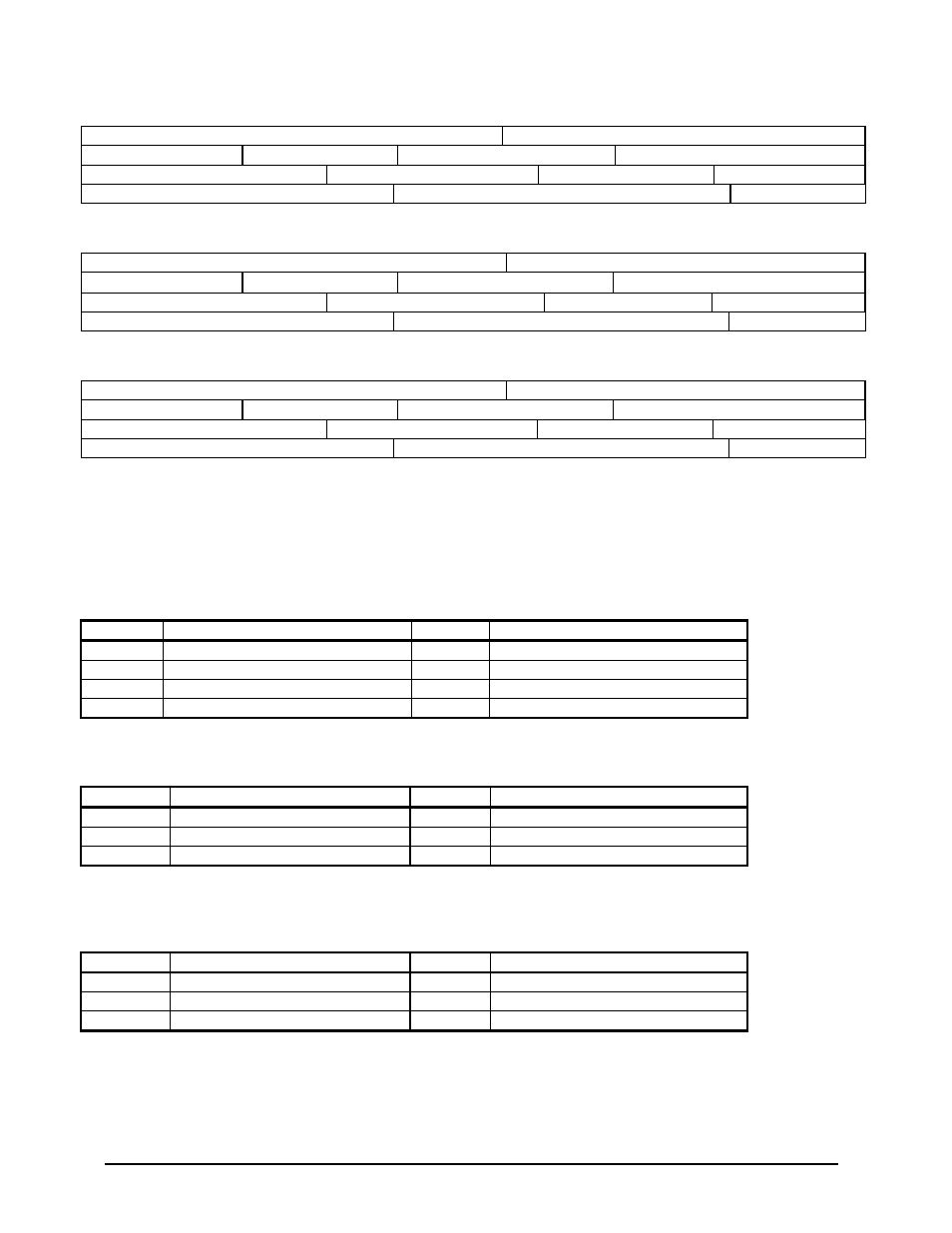
6.3.2 Uncorrected Barometric Altitude (203)
UNCORRECTED BAROMETRIC ALTITUDE
Source: ARINC 575 ADC
LABEL (Octal) 203
Units: Feet
Max. Range:
±
131,072 Feet
Approx. LSB: 1 Foot
Data Bits: 13 to 29 = 17
+ = Above Sea Level (ASL)
Sign Bit: Part of SSM
Pad Bits: 9 to 17
Transmit Interval (mSec): 62.5 Maximum
Data Type: 2’s Complement Binary
SDI Bits: N/A
6.3.3 Barometric Altitude Rate (212)
BAROMETRIC ALTITUDE RATE
Source: ARINC 575 ADC
LABEL (Octal) 212
Units: Feet/Minute
Max. Range:
±
20,480 Ft/Min
Approx. LSB: 10 Ft/Min
Data Bits: 19 to 29 = 11
+ = Ascent
Sign Bit: Part of SSM
Pad Bits: 9 to 18
Transmit Interval (mSec): 62.5 Maximum
Data Type: 2’s Complement Binary
SDI Bits: N/A
6.3.4 Computed Airspeed (206)
COMPUTED AIRSPEED
Source: ARINC 575 ADC
LABEL (Octal) 206
Units: Knots
Max. Range:
±
1024 Knots
Approx. LSB: 0.125 Knot
Data Bits: 17 to 29 = 13
+ = Forward
Sign Bit: Part of SSM
Pad Bits: 9 to 16
Transmit Interval (mSec): 125 Maximum
Data Type: 2’s Complement Binary
SDI Bits: N/A
6.4 Digital Data, RS-232
RS-232 data can be received and transmitted from an internal GPS Pxpress card in a TTL voltage level for use as a GPS
source. This data can also be received from a simulator in a TIA/EIA RS-232 format, which will be emulating the GPS
data format of the GPS Pxpress card. The characteristics of the GPS Pxpress data is 9600 baud, 1 stop bit, 8 bit data, odd
parity.
6.4.1 Xpress GPS Packets ID 15: Lat/Lon/Estimated Horizontal Position Error
Byte
Data
Type
Units
0
Valid Flag
Byte
Valid = 1, Invalid = 0
1-4
Latitude
Real
Radians (WGS 84)
5-8
Longitude
Real
Radians (WGS 84)
9-12
Horizontal Position Error (*)
Real
Meters
(*) Horizontal position error = 2 * standard deviation of horizontal position.
6.4.2 Xpress GPS Packets ID 16: Altitude/Estimated Vertical Position Error
Byte
Data
Type
Units
0
Valid Flag
Byte
Valid = 1, Invalid = 0
1-4
Altitude (*)
Real
Meters (MSL = WGS 84 - Geoid)
5-8
Vertical Position Error (**)
Real
Meters
(*) Altitude is MSL Altitude, which is computed from WGS 84 altitude by adding the geoid correction.
(**) Vertical position error = 2 * standard deviation of vertical position.
6.4.3 Xpress GPS Packets ID 17: Ground Speed/Track Angle
Byte
Data
Type
Units
0
Valid Flag
Byte
Valid = 1, Invalid = 0
1-4
Ground Speed
Real
Meters/Second
5-8
Track Angle
Real
Degrees (0..360)