Uncorrected barometric altitude (203), Static air temperature (213), Barometric altitude rate (212) – Honeywell MK VI User Manual
Page 278: Altitude (076) - gps (msl), Horizontal integrity limit (130) - gps, Ground speed (112) - gps
Honeywell
MK VI MK VIII EGPWS Installation Design Guide
Proprietary notice on title page applies
CAGE CODE: 97896
SCALE: NONE
SIZE: A
DWG NO: 060-4314-150
REV:
SHEET
278
B4
B3 B2 B1
0 0 0
0 0 1
0 1 0
0 1 1
1 0 0
1 0 1
1 1 0
1 1 1
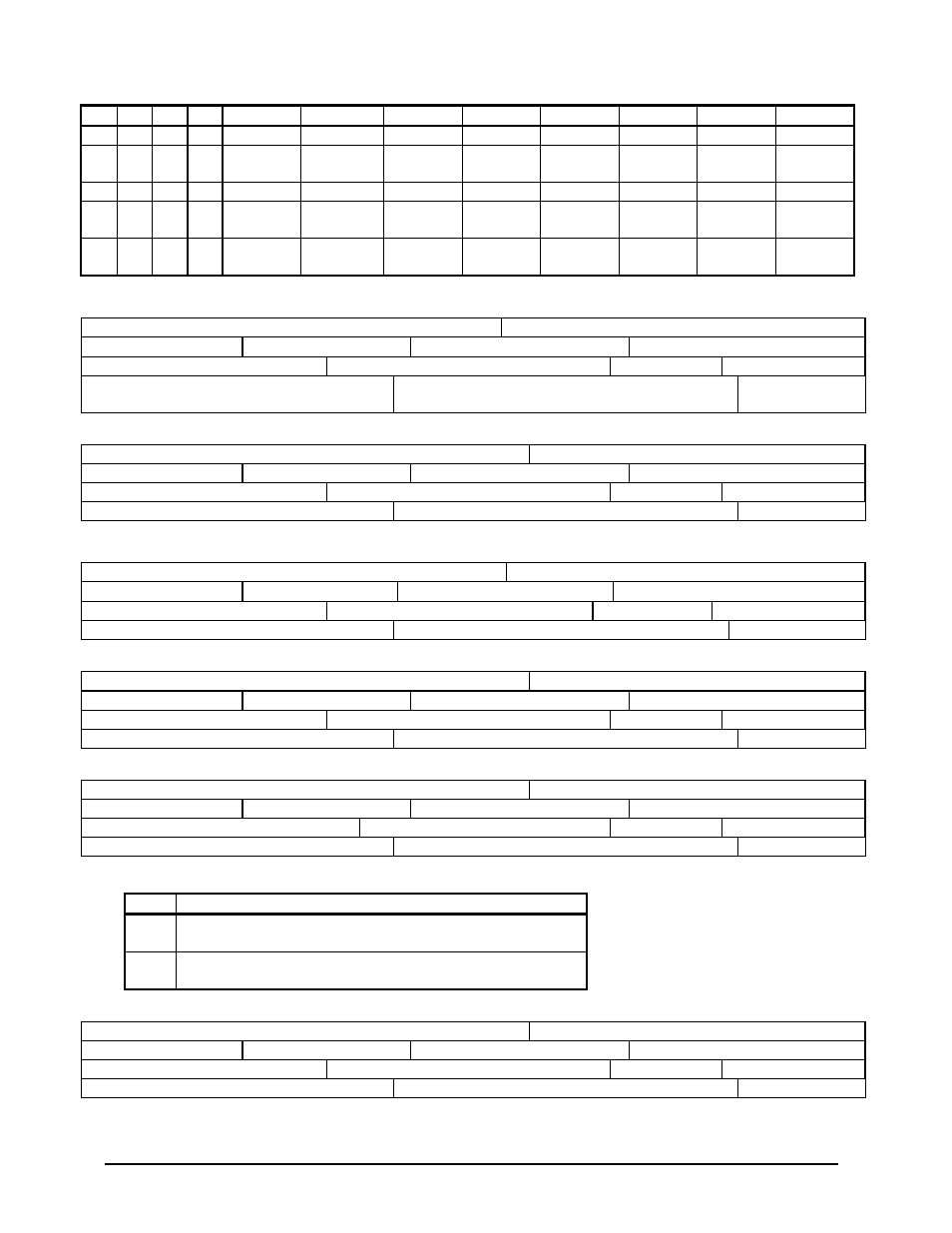
1
0
1
1
+
;
K
[
SER4
1
1
0
0
DEGREE
SYMBOL
,
<
L
\
SER5
1
1
0
1
BOX
-
=
M
]
SER6
1
1
1
0
↓
.
>
N
↑
TRI-
ANGLE
1
1
1
1
→
/
?
O
←
DIA-
MOND
6.2.1 Uncorrected Barometric Altitude (203)
UNCORRECTED BAROMETRIC ALTITUDE
Source: ARINC 706 DADC or IOC
LABEL (Octal) 203
Units: Feet
Max. Range:
±
131,072 Feet
Approx. LSB: 1 Foot
Data Bits: 12 to 28 = 17
+ = Above Sea Level (ASL)
Sign Bit: 29
Pad Bits: 11
Transmit Interval (mSec): 31.3 to 62.5
(50 if DAU)
Data Type: 2’s Complement Binary
SDI Bits: 9, 10
6.2.2 Static Air Temperature (213)
STATIC AIR TEMPERATURE
Source: ARINC 706 DADC or IOC
LABEL (Octal) 213
Units: Degrees Celsius
Max. Range: 512 Degrees C.
Approx. LSB: 0.25 Degree
Data Bits: 18 to 28 = 11
+ = Above ZERO
Sign Bit: 29
Pad Bits: 11 to 17
Transmit Interval (mSec): 250 to 500
Data Type: 2’s Complement Binary
SDI Bits: 9, 10
6.2.3 Barometric Altitude Rate (212)
BAROMETRIC ALTITUDE RATE
Source: ARINC 706 DADC or IOC
LABEL (Octal) 212
Units: Feet/Minute
Max. Range:
±
32,768 Ft/Min
Approx. LSB: 16 Ft/Min
Data Bits: 18 to 28 = 11
+ = Ascent
Sign Bit: 29
Pad Bits: 11 to 17
Transmit Interval (mSec): 31.3 to 62.5
Data Type: 2’s Complement Binary
SDI Bits: 9, 10
6.2.4 Altitude (076) - GPS (MSL)
ALTITUDE – GPS (MSL)
Source: ARINC 743(A) GPSSU
LABEL (Octal) 076
Units: Feet
Max. Range: 131,072 Feet
Approx. LSB: 0.125 Foot
Data Bits: 9 to 28 = 20
+ = Up
Sign Bit: 29
Pad Bits: None
Transmit Interval (mSec): 1000 Maximum
Data Type: 2’s Complement Binary
SDI Bits: None
6.2.5 Horizontal Integrity Limit (130) - GPS
GPS Horizontal Integrity Limit
Source: ARINC 743(A) GPS
LABEL (Octal) 130
Units: Nautical Miles
Max. Range: 16
Approx. LSB: 0.00012207
Data Bit: 12 - 28 (see table below) = 17
+ = always positive
Sign Bit: N/A
Pad Bits: N/A
Transmit Interval (mSec): 1000 ms
Data Type: BNR + discrete
SDI Bits: 9, 10
BIT ASSIGNMENT GPS HIL
Bit
Definition
11
Set to 1 whenever the receivers RAIM detects a non-isolatable
satellite failure (NISF), set to 0 otherwise
12 –
28
Integrity limit in nautical miles
6.2.6 Ground Speed (112) - GPS
Ground Speed – GPS
Source: ARINC 743(A) GPSSU
LABEL (Octal) 112
Units: Knots
Max. Range: 4,096 Knots
Approx. LSB: 0.125 Knot
Data Bits: 14 to 28 = 15
+ = Forward
Sign Bit: 29
Pad Bits: 11 to 13
Transmit Interval (mSec): 1000 Maximum
Data Type: 2’s Complement Binary
SDI Bits: 9, 10