Latitude (110) - gps, Longitude (111) - gps, Track angle (103) - gps – Honeywell MK VI User Manual
Page 279: Horizontal figure of merit \(247\) – gps \(ar, Horizontal figure of merit from hdop \(101\), Vertical figure of merit \(136\) – gps \(arin, Vertical figure of merit from vdop \(102\)
Honeywell
MK VI MK VIII EGPWS Installation Design Guide
Proprietary notice on title page applies
CAGE CODE: 97896
SCALE: NONE
SIZE: A
DWG NO: 060-4314-150
REV:
SHEET
279
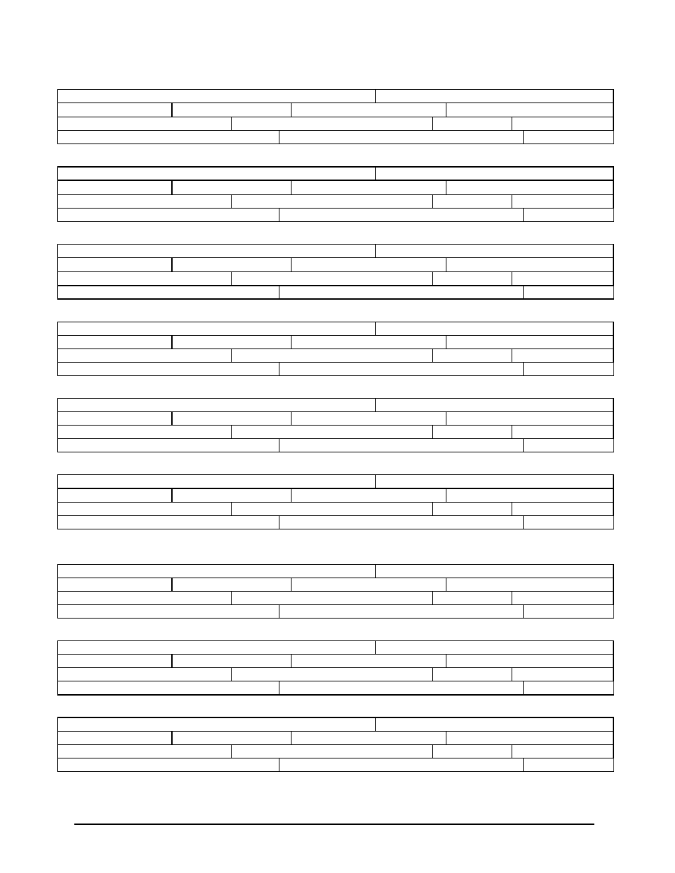
6.2.7 Latitude (110) - GPS
LATITUDE – GPS
Source: ARINC 743(A) GPSSU
LABEL (Octal) 110
Units: Degrees
Max. Range:
±
180 Degrees
Approx. LSB: 0.000172 Deg
Data Bits: 9 to 28 = 20
+ = North
Sign Bit: 29
Pad Bits: None
Transmit Interval (mSec): 1000 Maximum
Data Type: 2’s Complement Binary
SDI Bits: 9, 10
6.2.8 Longitude (111) - GPS
LONGITUDE – GPS
Source: ARINC 743(A) GPSSU
LABEL (Octal) 111
Units: Degrees
Max. Range:
±
180 Degrees
Approx. LSB: 0.000172 Deg
Data Bits: 9 to 28 = 20
+ = East
Sign Bit: 29
Pad Bits: None
Transmit Interval (mSec): 1000 Maximum
Data Type: 2’s Complement Binary
SDI Bits: 9, 10
6.2.9 Track Angle (103) - GPS
TRACK ANGLE – GPS
Source: ARINC 743(A) GPSSU
LABEL (Octal) 103
Units: Degrees
Max. Range:
±
180 Degrees
Approx. LSB: 0.0055 Deg.
Data Bits: 15 to 29 = 15
+ = Clockwise from North
Sign Bit: 29
Pad Bits: 11 to 14
Transmit Interval (mSec): 1000 Maximum
Data Type: 2’s Complement Binary
SDI Bits: 9, 10
6.2.10 Horizontal Figure Of Merit (247) – GPS (ARINC 743A)
HORIZONTAL FIGURE OF MERIT - GPS
Source: ARINC 743A GPSSU
LABEL (Octal) 247
Units: Nautical Miles
Max. Range: 16 NM’s
Approx. LSB: 0.000061035
Data Bits: 11 to 28 = 18
+ = N/A
Sign Bit: 29
Pad Bits: N/A
Transmit Interval (mSec): 1000 Maximum
Data Type: 2’s Complement Binary
SDI Bits: 9, 10
6.2.11 Horizontal Figure Of Merit (247) – GPS (ARINC 743)
HORIZONTAL FIGURE OF MERIT - GPS
Source: ARINC 743 GPSSU
LABEL (Octal) 247
Units: Meters
Max. Range: 1,024
Approx. LSB: 0.03125
Data Bits: 14 to 28 = 15
+ = N/A
Sign Bit: 29
Pad Bits: 11 to 13
Transmit Interval (mSec): 1000 Maximum
Data Type: 2’s Complement Binary
SDI Bits: 9, 10
6.2.12 Horizontal Figure Of Merit from HDOP (101) – GPS (ARINC 743)
HORIZONTAL FIGURE OF MERIT – GPS
Source: ARINC 743 GPSSU
LABEL (Octal) 101
Units: Meters
Max. Range: 16,384*
Approx. LSB: 0.5*
Data Bits: 14 to 28 = 15
+ = N/A
Sign Bit: 29
Pad Bits: 11 to 13
Transmit Interval (mSec): 1000 Maximum
Data Type: 2’s Complement Binary
SDI Bits: 9, 10
* The HDOP scaling is multiplied by 16 to produce HFOM values required by the EGPWS
6.2.13 Vertical Figure Of Merit (136) – GPS (ARINC 743A)
VERTICAL FIGURE OF MERIT – GPS
Source: ARINC 743A GPSSU
LABEL (Octal) 136
Units: Feet
Max. Range: 32,768 ft
Approx. LSB: 0.125
Data Bits: 11 to 28 = 18
+ = N/A
Sign Bit: 29
Pad Bits: N/A
Transmit Interval (mSec): 1000 Maximum
Data Type: 2’s Complement Binary
SDI Bits: 9, 10
6.2.14 Vertical Figure Of Merit (136) – GPS (ARINC 743)
VERTICAL FIGURE OF MERIT – GPS
Source: ARINC 743 GPSSU
LABEL (Octal) 136
Units: Meters
Max. Range: 1,024
Approx. LSB: 0.03125
Data Bits: 14 to 28 = 15
+ = N/A
Sign Bit: 29
Pad Bits: 11 to 13
Transmit Interval (mSec): 1000 Maximum
Data Type: 2’s Complement Binary
SDI Bits: 9, 10
6.2.15 Vertical Figure Of Merit from VDOP (102) – GPS (ARINC 743)
VERTICAL FIGURE OF MERIT – GPS
Source: ARINC 743 GPSSU
LABEL (Octal) 102
Units: Meters
Max. Range: 16,384*
Approx. LSB: 0.5*
Data Bits: 14 to 28 = 15
+ = N/A
Sign Bit: 29
Pad Bits: 11 to 13
Transmit Interval (mSec): 1000 Maximum
Data Type: 2’s Complement Binary
SDI Bits: 9, 10
* The VDOP scaling is multiplied by 16 to produce VFOM values required by the EGPWS