Hazard avoidance, Displaying traffic data – Garmin G1000 Piper PA32 User Manual
Page 340
Garmin G1000 Pilot’s Guide for Piper PA32
190-00692-00 Rev. B
6-60
HAZARD AVOIDANCE
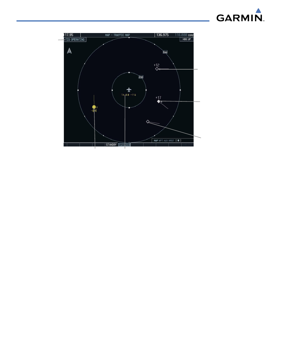
Figure 6-60 Traffic Map Page - Advisories
Non-Threat
Traffic
Non-Threat
Traffic
Proximity
Advisory, Aircraft
is 1700’ Above
and Descending
- Moving in the
Direction of the
Vector Line
Traffic Advisory,
Aircraft is 400’
Below and Climbing
“Non-Bearing” Traffic (System is
Unable to Determine Bearing), Aircraft Distance
is 8.0 nm, 1100’ Above and Descending
Operating
Mode
TIS also displays non-bearing traffic, or traffic for which it is unable to determine the bearing. Non-bearing
traffic alert messages display in the center of the Traffic Map Page.
DISPLAYING TRAFFIC DATA
Traffic information can be displayed on the following pages:
• Traffic Map Page
• AUX - Trip Planning Page
• Navigation Map
• Nearest Pages
• WPT - VOR Information Page
• FPL - Active Flight Plan Page
• PFD Inset Map
To display traffic on any page other than the Traffic Map Page, press the MAP Softkey, followed by the
TRAFFIC Softkey.
Displaying traffic on the Traffic Map Page:
1)
Select the Map Page Group.
2)
Press the Traffic Map Page.
3)
Press the
OPERATE
Softkey to begin displaying traffic. ‘TIS OPERATING’ is displayed in the upper left corner of
the page. Alternatively, press the
STANDBY
Softkey to place the system in the Standby mode. ‘TIS STANDBY’
displays in the upper left corner of the page.
4)
Turn the
Joystick
clockwise to display a larger area or counter-clockwise to display a smaller area. Map ranges
are 2 nm, 6 nm, and 12 nm.