Hazard avoidance – Garmin G1000 King Air C90GT User Manual
Page 406
Garmin G1000 Pilot’s Guide for the Hawker Beechcraft C90A/GT
190-00663-01 Rev. A
392
HAZARD AVOIDANCE
SY
STEM
O
VER
VIEW
FLIGHT
INSTRUMENTS
EIS
AUDIO P
ANEL
& CNS
FLIGHT
MANA
GEMENT
HAZARD
AV
OID
ANCE
AFCS
ADDITIONAL FEA
TURES
APPENDICES
INDEX
Traffic information is also displayed on the PFD when the Synthetic Vision System (SVS) option is installed and
enabled. See the Additional Features Section for details.
Displaying traffic on the Traffic Map Page:
1)
Use the large FMS Knob to select the Map Page Group.
2)
Use the small FMS Knob to select the Traffic Map Page.
3)
Select the NORMAL Softkey to begin displaying traffic. OPERATING is displayed in the Traffic mode field.
4)
Select the ALT MODE Softkey to change the altitude volume.
5)
Select the STANDBY Softkey to place the system in the Standby mode. STANDBY is displayed in the Traffic
mode field.
6)
Turn the RANGE Knob clockwise to display a larger area or counter-clockwise to display a smaller area.
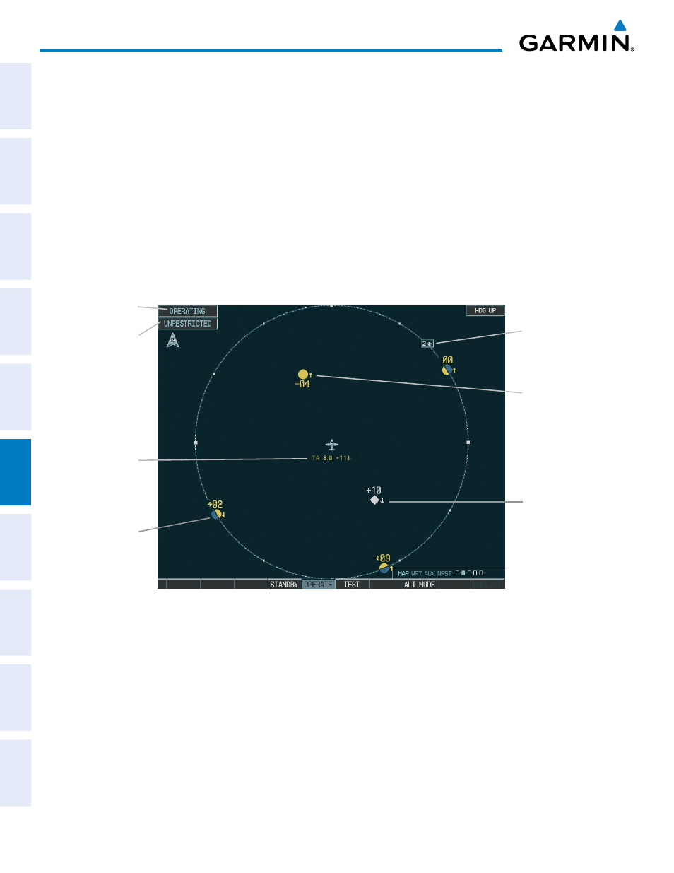
Figure 6-111 Traffic Map Page
Operating
Mode
Altitude
Mode
Traffic Advisory,
Aircraft is
400’ Below,
Climbing
Off Scale
Traffic
“Non-Bearing”
Traffic (Bearing
Undetermined),
Distance 8.0 nm,
1100’ Above,
Descending
Proximity
Traffic, 1000’
Above,
Descending
Traffic Display
Range
The Traffic Map Page shows surrounding TAS traffic data in relation to the aircraft’s current position and
altitude, without basemap clutter. Aircraft orientation is always heading up unless there is no valid heading.
Map range is adjustable with the RANGE Knob from 2 to 40 nm, as indicated by the map range rings.
The traffic mode and altitude display mode are annunciated in the upper left corner.
Displaying traffic information (maps other than the Traffic Map Page):
1)
Select the MAP Softkey.
2)
Select the TRAFFIC Softkey. Traffic is now displayed on the map.