Limitations, Hazard avoidance – Garmin G1000 Mooney M20TN User Manual
Page 271
190-00647-00 Rev. A
Garmin G1000 Pilot’s Guide for the Mooney M20M/M20R/M20TN
6-35
HAZARD AVOIDANCE
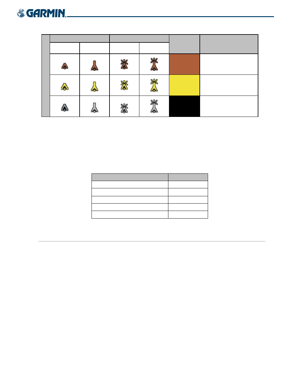
Unlighted Obstacle
Lighted Obstacle
Terrain Color Terrain/Obstacle Location
< 1000’ AGL
> 1000’ AGL
< 1000’ AGL
> 1000’ AGL
Obstacle Symbol
Red
Terrain/Obstacle above or
within 100 ft below the
aircraft altitude
Yellow
Terrain/Obstacle between
100 ft and 1000 ft below the
aircraft altitude
Black
Terrain/Obstacle more than
1000 ft below the aircraft
altitude
Table 6-6 Terrain Proximity and Colors
Obstacles are displayed only at certain map zoom ranges, on certain maps, and will only be displayed if an
obstacle database is loaded on the SD card. In addition, all map zoom ranges are dependent on the zoom range
setting in the Navigation Map. If the zoom range on the Navigation Map is adjusted to below 20 nm, the highest
zoom range on all other maps is also adjusted proportionally.
Table 6-7 shows the map pages and the highest zoom range at which obstacles are displayed.
MAP
nm
Navigation Map Page
50
Inset Map
10
Terrain Proximity Page
10
AUX - Trip Planning Page
10
Active Flight Plan Pages
15
Table 6-7 Zoom Ranges for Displaying Obstacle Data
LIMITATIONS
Terrain Proximity displays altitudes of terrain and obstructions relative to the aircraft position and altitude
with reference to a database that may contain inaccuracies. Terrain and obstructions are shown only if they
are in the database. Terrain and obstacle information should be used as an aid to situational awareness. They
should never be used to navigate or maneuver around terrain.
Note that all obstructions may not be available in the terrain and obstacle database. No terrain and obstacle
information is shown without a valid 3D GPS position.