Taws symbols, Taws alerts, Hazard avoidance – Garmin G1000 Quest Kodiak User Manual
Page 266
Garmin G1000 Pilot’s Guide for the Quest Kodiak 100
190-00590-00 Rev. C
6-34
HAZARD AVOIDANCE
TAWS SYMBOLS
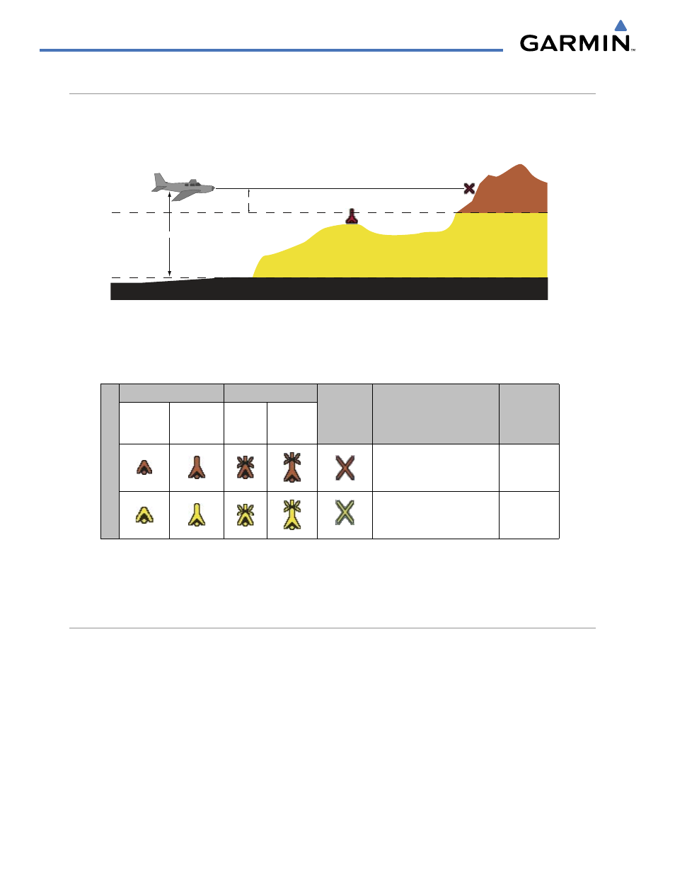
The symbols and colors in Figure 6-40 and Table 6-4 are used to represent obstacles and potential impact
points on the TAWS Page. TAWS uses yellow (caution) and red (warning) to depict terrain information relative
to aircraft altitude.
Potential Impact Point
Unlighted Obstacle
Projected Flight Path
1000 ft
100 ft Threshold
Terrain above or
within 100 ft
below the aircraft
altitude
Terrain between 100 ft and 1000 ft below the
aircraft altitude
Terrain more than 1000 ft below the aircraft altitude
Figure 6-40 Terrain Altitude/Color Correlation for TAWS
Each color is associated with an alert severity level. Terrain graphics and visual annunciations also use these
color assignments.
Unlighted Obstacle
Lighted Obstacle
Potential
Impact
Points
Obstacle Location
Alert Level
< 1000’
AGL
> 1000’
AGL
< 1000’
AGL
> 1000’
AGL
Obstacle Symbol
Obstacle above or within
100’ below current aircraft
altitude
WARNING
Obstacle between 100’ and
1000’ below current aircraft
altitude
CAUTION
Table 6-4 TAWS Terrain/Obstacle Colors and Symbology
Note that if an obstacle and the projected flight path of the aircraft intersect, the display automatically
zooms in to the closest potential point of impact on the TAWS Page.
TAWS ALERTS
Alerts are issued when flight conditions meet parameters that are set within TAWS software algorithms.
TAWS alerts typically employ either a CAUTION or a WARNING alert severity level, or both. When an alert is
issued, visual annunciations are displayed. Aural alerts are simultaneously issued.