Application boundary, Mark a – TeeJet Matrix Pro 840GS User Manual
Page 50
44
www.teejet.com
HOME
OVER
VIE
W
SE
TUP
IMPLEMENT
FULL SCREEN
GPS
INTR
ODUC
TION
GUID
ANCE
DR
OPLE
T MONIT
OR
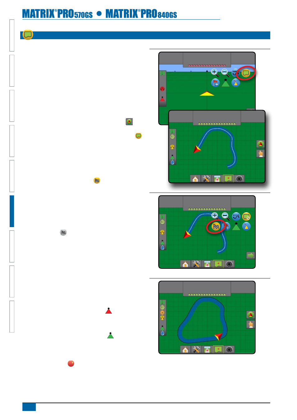
aPPliCatiOn BOundarY
Application boundaries establish areas where application is and
is not applied while using ABSC or BoomPilot. Boundaries can be
established in all guidance modes. One exterior boundary and up
to five (5) interior boundaries can be stored at one time.
Using Data->Job data->Manage or with Fieldware Link, a user can
duplicate and edit jobs for reuse of boundaries and guidelines for
different applications over the same field.
To establish an exterior application boundary:
1. Drive to a desired location at the perimeter of the field/
application area.
2. Press NAVIGATION AND GUIDANCE OPTIONS tab
to
display navigation options.
3. While the vehicle is in motion, press BOUNDARY icon
.
4. Travel the perimeter of the field/area.
5. Finish boundary:
►Travel to within one swath width of the starting point. The
boundary will close automatically (the white guideline will
turn black)
►Press BOUNDARY FINISH icon . A straight line will
complete the boundary between your current location and
the starting point
6. Press:
►Save – to save the boundary
►Delete – to delete the boundary
NOTE: On the external or initial boundary, the BOUNDARY
FINISH icon is not available for selection (greyed
out) until the minimum distance is travelled (five-times the
swath width).
If mapping a boundary with one or more booms folded in and
turned off, it is necessary to maintain this boom configuration
for the duration of the boundary pass. Any changes made to
the number of booms turned on, and therefore the width of the
machine after the boundary mapping process has started, will
result in the application mapping the boundary at the outer edge
of all the programmed booms – not necessarily those turned on at
any given point in time during the boundary pass .
When mapping a boundary with some booms turned off, it is
necessary to turn BoomPilot to Manual mode and turn ON the
Master and Boom switches for all booms that will be used during
the boundary pass. Once the boundary pass is complete the
Boom switches can be turned OFF, Master switch remains ON,
BoomPilot can be returned to Automatic mode and automatic
boom section control can then be used.
Note: If a boundary is mapped with some booms folded
as described above, it may be necessary to use the
A+ NUDGE icon
A
on the guideline over to the correct
position for subsequent passes in the field.
Figure 6-30: Boundary in progress
0.00
ha
0.0
km/h
2.32
ha
7.2
km/h
Mark A
Figure 6-31: Finish boundary – Straight line to starting point
2.32
ha
7.2
km/h
Mark A
Figure 6-32: Finish boundary – Travel to starting point
4.68
ha
7.2
km/h
Mark A