Job view, Guidance screens, Field view options – TeeJet Matrix 840G User Manual User Manual
Page 55: Realview guidance options, Status bar icons, Vehicle view options
www.teejet.com
90
●
98-05141 R2
91
●
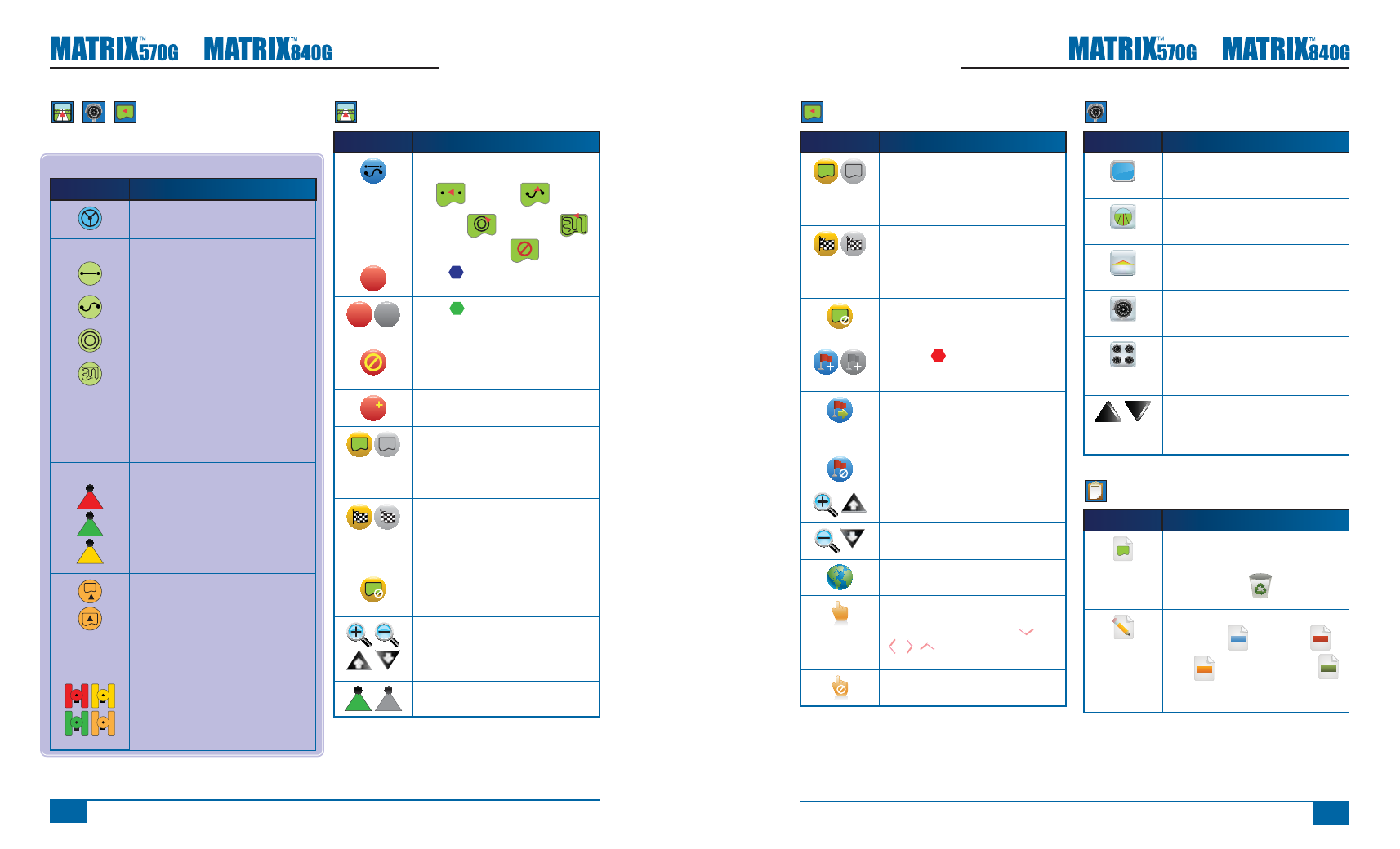
Field View Options
Icon
Description
Mark Boundary. Establishes application
area and determines the no apply zone.
Boundary is established to the outside
of an applied pass. Grayed = GPS is
unavailable
Finish Boundary. Finalizes boundary
process. Boundaries can also be closed
by travelling to within a swath width of the
starting point. Grayed = minimum distance
has not been traveled.
Cancel Boundary. Cancels the new map
boundary process. Reverts to previous
boundary (when established).
Mark Point
. Establishes a point at
the vehicle location. Grayed = GPS is
unavailable.
Return to Point. Provides distance back
to an established point. (Switch to Vehicle
View to provide navigation back to an
established point.)
Cancel Point. Deletes the Marked Point.
Zoom In. Icon or button decreases the
area displayed on the screen.
Zoom Out. Icon or button increases the
area displayed on the screen.
World View. Extends screen view to the
widest area available.
Pan. Allows operator to focus on specifi c
map areas without moving the vehicle.
Arrows on screen move the view
(down, left, right, up) in the
corresponding direction.
Cancel Pan. Cancels the focal area and
returns to normal viewing.
RealView Guidance Options
Icon
Description
Full Screen. Removes the icons and status
bars from the screen. Guidance Over Video
and Steering Angle will still be visible.
Guidance Over Video. Places three-
dimensional guidelines over the video feed
for navigational assistance.
Steering Angle. Displays the direction
in which the steering wheel needs to be
adjusted.
Video Camera Select. Selects one of up
to eight camera views if a Video Selection
Module (VSM) is attached.
Split Camera View. Selects one of two sets
of four camera inputs (A/B/C/D or E/F/G/H)
to divide the screen into four separate
video feeds.
Up & Down Icons. Used to adjust the
guidance lines to match the camera’s view.
Zoom In/Out Buttons will not adjust the
guidance lines.
Job View
Icon
Description
Job Information. Gives options to clear all
current job information, bounded areas
information or area counters.
Press the trash can
to delete
selected information.
Save Information.
Saves all data
ALL
including PDF
, KML
KML
(Google Earth) and SHP
SHP
(ESRI) fi les or each individual type to USB
drive.
Guidance Screens
Status Bar Icons
Icon
Description
FieldPilot Status. Icon = engaged.
No icon = disengaged.
Guidance Mode.
Straight A-B Guidance. Provides straight
line guidance based on A and B reference
points.
Curved A-B Guidance. Provides curved
guidance based on a reference (A-B) line.
Circle Pivot Guidance. Provides guidance
around a central location that radiates
inward or outward.
Last Pass Guidance. The console will
detect the nearest adjacent applied swath
and establish guidance based on it.
No Guidance. Turns off guidance. No Icon
will be displayed.
BoomPilot Status.
Red = Off/Manual
Green = Automatic
Yellow = All On
No icon = Single Boom Section (no
SmartCable or SDM installed on system).
Bounded Area Status.
Outside Boundary = Currently traveling
outside bounded area.
Inside Boundary = Currently traveling
inside bounded area.
No icon = No boundary established
GPS Status.
Red = no GPS
Yellow = GPS only
Green = DGPS,WAAS/RTK
Peach = Glide/ClearPath
Vehicle View Options
Icon
Description
Guidance Mode. Press to select a
guidance mode. Modes include Straight
A-B
, Curved A-B
,
Circle Pivot
and Last Pass
or No Guidance Mode
.
A
Mark A
. Press to mark the fi rst point of
the initial guideline.
B
B
Mark B
. Press to mark the end point
of the initial guideline. Grayed = minimum
distance has not been traveled.
Cancel Mark A. Cancels the Mark A
process. Reverts to previous A-B guideline
(when established).
A
A+ Nudge. Shifts the existing guideline to
the vehicle’s current position.
Mark Boundary. During Last Pass
Guidance, establishes application area and
determines the no apply zone. Boundary
is established to the outside of an applied
pass. Grayed = GPS is unavailable
Finish Boundary. Finalizes boundary
process. Boundaries can also be closed
by travelling to within a swath width of the
starting point. Grayed = minimum distance
has not been traveled.
Cancel Boundary. Cancels the new map
boundary process. Reverts to previous
boundary (when established).
Zoom In/Out. Icons or buttons adjust the
vehicle’s view or perspective to the horizon
from vehicle view to bird’s eye view.
BoomPilot. Selects BoomPilot mode.
Grayed = GPS is unavailable