Garmin 210 User Manual
Page 54
Attention! The text in this document has been recognized automatically. To view the original document, you can use the "Original mode".
Sdfrtiug On-Saeai
Display Features
Map Display Configuration
Scale Cnm)
644-32 16
n
□
□
n
13
25. 125
Geo Names
S'
s s s s s s s s
□
Navaid Text
□
□
□
□
□
□
□
□
s s
Depth, Shallow
□
□
□
s s s s s s s
Depth, Medium □
□
□
s s s s s s s
Depth, Deep
□ □ s □ s s s s s
□
Land rills
s
□
s s s s s s s s
Lat/Lon Grid
s
□
□
□
□
□
□
□
□
□
Lat/Lon Label
□
□
□
□
□
□
□
□
□
□
Haypoints
s s s s s s s s s
Naypt Names
□
□
s s s s s s s s
Gctive Route
S'
s s s s s s s s s
Track
s s s s s s s a s s
1
Press ENT to toggle item on/off on map d ispi
gy 1
I Defaults t [ Set Row t rcir Row I rMaFCaTIl I E»it~
Map Display Configuration
Scale (nm)
641.
m
16
n □
B
1 .5
25. 125
Geo Names
s s s s s s s
s
□
Navaid Text
□
□
□
□
□ □ □
□
s s
Depth, Shallow
□ □
□
s s s s
s
s s
Depth, Medium □
□
□
□
□
□
□
□
□
□
Depth, Deep
n n s □ s s s s s □
Land FRIs
s □ s s s s s s s s
Lat/Lon Grid
s □ □ □ n □ n □ □ □
Lat/Lon Label
□ □ □ □ □ □ □ □ □ □
Haypnnts
s s s s s s s s s s
Naypt Names
□ □ s s s s s s s s
Active Route
s s s s s s s s s s
Track
s s s s s s s s s s
1 Press ENT to toggle item on/off on map display |
44
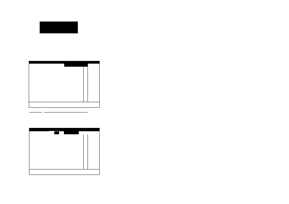
The GARMIN GPSMAP system features a graphic map display with 16
zoom scales from l/8th to 4096 n.m. (0.250 to 7500km). By using G-chart™
electronic chart cartridges, the map display can show a wide variety of chart
details such as depth contours, routes and track plots, and waypoints.
The MAP CFG softkey allows you to determine what chart features are dis
played on a particular range scale. By selecting individual features on the map
configuration window, you can choose what specific information to display.
To access the map display configuration window:
1. Press the MAP CFG softkey.
The configuration window features an on/off grid with a list of chart fea
tures down the left side of the grid. The zoom scales are displayed across the
top of the grid, with the chart scale currently in use indicated hy a hox outline
around the selection grid (the far left column denotes range scales 64 n.m.
(120 km) and greater). A check mark in a grid box indicates that the chart fea
ture listed will be displayed at the scale marked at the top of the grid.
Individual grid boxes are turned on and off with the ENTER key, while
entire rows may be controlled by the using the configuration softkeys.
To use the map configuration grid;
1. Use the # key to toggle an individual grid box on or off.
2. Press the DEFAULTS softkey to return the entire grid to the factory settings.
3. Use the SET ROW softkey to turn an entire horizontal row on.
4. Use the CLR ROW softkey to turn an entire horizontal row off.
Note that geographic names and navaid text can’t be displayed simultane
ously at range scales greater than 2 n.m. (4 km) and that navaid text is always