Displaying terrain-svs data, Hazard avoidance – Garmin G1000 Piper PA-46 Meridian User Manual
Page 363
190-00763-01 Rev. A
Garmin G1000 Pilot’s Guide for the Piper PA-46 Meridian
349
HAZARD AVOIDANCE
SY
STEM
O
VER
VIEW
FLIGHT
INSTRUMENTS
EICAS
AUDIO P
ANEL
& CNS
FLIGHT
MANA
GEMENT
HAZARD
AV
OID
ANCE
AFCS
ADDITIONAL
FEA
TURES
APPENDICES
INDEX
aircraft. GPS position and GPS-MSL altitude are used to calculate and predict the aircraft’s flight path in relation
to the surrounding terrain and obstacles. In this way, the pilot can view predicted dangerous terrain and obstacle
conditions.
DISPLAYING TERRAIN-SVS DATA
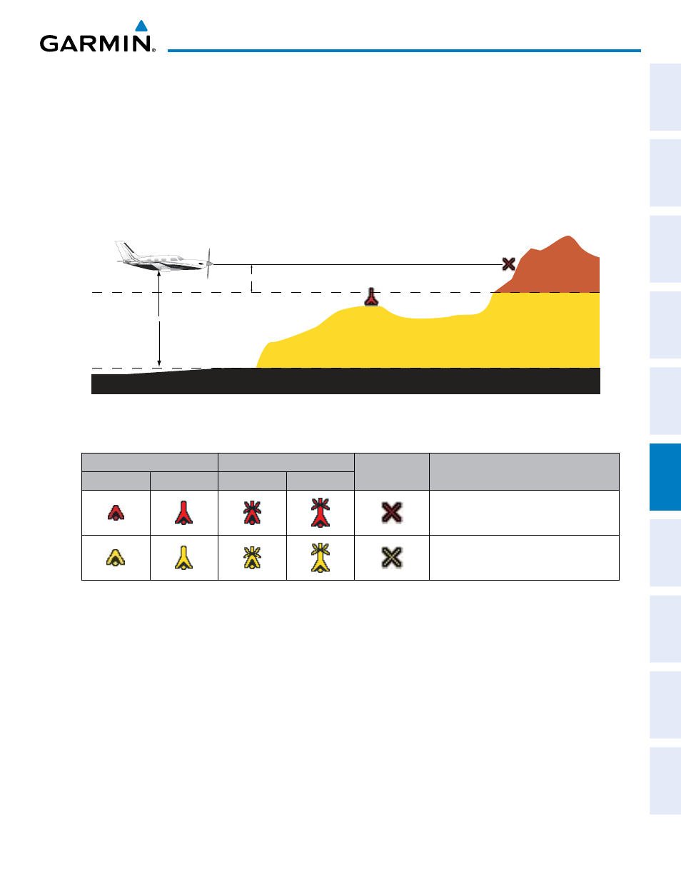
TERRAIN-SVS uses yellow (caution) and red (warning) to depict terrain and obstacles (with heights greater
than 200 feet above ground level, AGL) alerts relative to aircraft altitude. Colors are adjusted automatically as
the aircraft altitude changes. The colors and symbols in Figure 6-63 and Table 6-6 are used to represent terrain,
obstacles, and potential impact points.
Potential Impact Point
Unlighted Obstacle
Projected Flight Path
1000 ft
100 ft Threshold
Terrain more than 1000 ft below the aircraft altitude
Terrain between 100 ft and 1000 ft below the
aircraft altitude
Terrain above or
within 100 ft
below the aircraft
altitude
Figure 6-63 Terrain Altitude/Color Correlation for TERRAIN-SVS
Unlighted Obstacle
Lighted Obstacle
Potential
Impact Points
Obstacle Location
< 1000’ AGL > 1000’ AGL < 1000’ AGL > 1000’ AGL
WARNING: Red obstacle is above or within
100’ below current aircraft altitude
CAUTION: Yellow obstacle is between 100’
and 1000’ below current aircraft altitude
Table 6-6 TERRAIN-SVS Obstacle Colors and Symbology
TERRAIN-SVS information can be displayed on the following maps:
• PFD Inset Map
• Navigation Map Page
• TERRAIN-SVS Page
• Trip Planning Page
• Flight Plan Pages