Flight management – Garmin G1000 Piper PA-46 Meridian User Manual
Page 252
Garmin G1000 Pilot’s Guide for the Piper PA-46 Meridian
190-00763-01 Rev. A
238
FLIGHT MANAGEMENT
SY
STEM
O
VER
VIEW
FLIGHT
INSTRUMENTS
EICAS
AUDIO P
ANEL
& CNS
FLIGHT
MANA
GEMENT
HAZARD
AV
OID
ANCE
AFCS
ADDITIONAL FEA
TURES
APPENDICES
INDEX
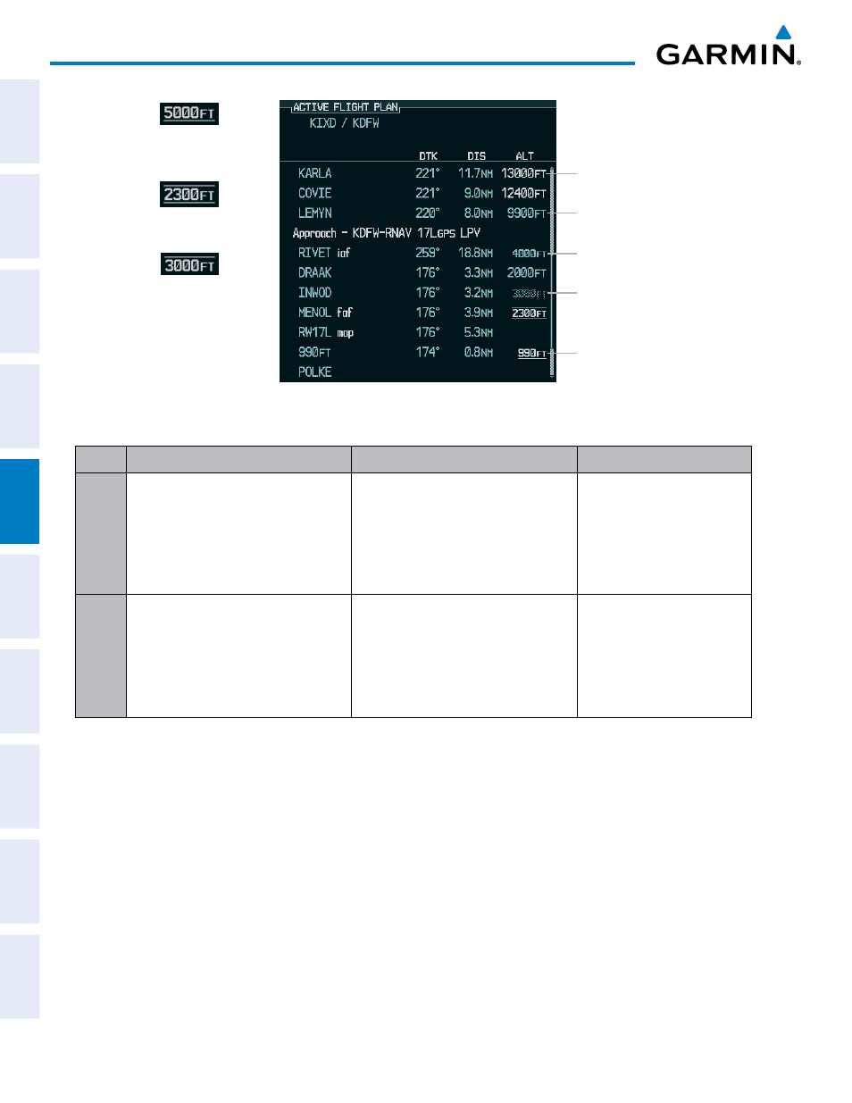
Large Light Blue Text
Small White Text with
Altitude Restriction Bar
Large White Text
Small Light Blue
Subdued Text
Small Light Blue Text
Figure 5-87 Waypoint Altitude Constraints
Cross AT
or ABOVE
5,000 ft
Cross AT
or BELOW
3,000 ft
Cross AT
2,300 ft
Altitude Constraint
Examples
Displayed Text
Examples
White Text
Light Blue Text
Light Blue Subdued Text
Large
Text
Altitude calculated by the system
estimating the altitude of the aircraft as
it passes over the navigation point. This
altitude is provided as a reference and is
not designated to be used in determining
vertical speed and deviation guidance.
Altitude has been entered manually.
Altitude is designated for use in giving
vertical speed and deviation guidance.
Altitude does not match the published
altitude in navigation database or no
published altitude exists.
The system cannot use this
altitude in determining vertical
speed and deviation guidance
because of an invalid constraint
condition
Small
Text
Altitude is not designated to be used in
determining vertical speed and deviation
guidance. Altitude has been retrieved
from the navigation database and is
provided as a reference.
Altitude is designated for use in giving
vertical speed and deviation guidance.
Altitude has been retrieved from the
navigation database or has been entered
manually and matches a published
altitude in the navigation database.
The system cannot use this
altitude in determining vertical
speed and deviation guidance
because of an invalid constraint
condition
Table 5-8 Altitude Constraint Size and Color Coding
Altitudes associated with approach procedures are “auto-designated”. This means the system automatically
uses the altitudes loaded with the arrival or approach for giving vertical speed and deviation guidance. Note
that these altitudes are displayed as blue text up to, but not including the FAF. The FAF is always a “reference
only” altitude and cannot be designated, unless the selected approach does not provide vertical guidance. In
this case, the FAF altitude can be designated.
Altitudes that have been designated for use in vertical guidance can be “un-designated” using the CLR Key.
The altitude is now displayed only as a reference. It is not used to give vertical guidance. Other displayed
altitudes may change due to re-calculations or be rendered invalid as a result of manually changing an altitude
to a non-designated altitude.