Map operation – BendixKing KMD 250 User Manual
Page 38
1-19
KMD 250 Pilot's Guide
Section 1
Basic Operation
Rev 2 Apr/2004
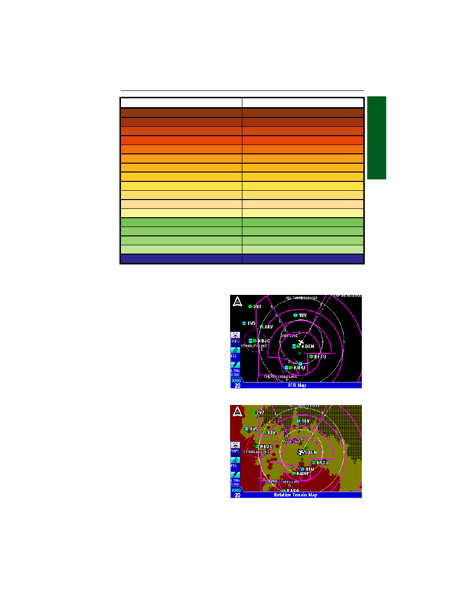
IFR MAP
Terrain is not displayed on the
IFR Map display as shown in
Figure 1-16. In addition, all
built up or urban areas are
shaded light gray. Oceans,
rivers and lakes are blue.
RELATIVE TERRAIN MAP
With Relative Terrain Map dis-
played, topographic data and
obstructions are displayed as
colors corresponding to eleva-
tion relative to the aircraft’s
present altitude as shown in
Figure 1-17. This feature is
useful in providing awareness
to possible terrain hazards at
the present aircraft altitude.
Table 1-2 shows the levels and
terrain shading used on the
Relative Terrain Map.
Figure 1-16 - IFR Map
Figure 1-17 - Relative Terrain Map
Absolute Terrain Altitude (feet)
Color
13000+
Dark Brown
11500-12999
⇓
10000-11499
⇓
9000-9999
⇓
8000-8999
⇓
7000-7999
Light Brown
6000-6999
Dark Tan
5000-5999
⇓
4000-4999
⇓
3000-3999
⇓
2500-2999
⇓
2000-2499
Light Tan
1500-1999
Dark Green
1000-1499
⇓
500-999
⇓
<499
Light Green
Water
Blue
Table 1-1 Absolute Terrain (VFR Map)
Map Operation
- AV8OR (368 pages)
- AV8OR (2 pages)
- AV8OR Ace - Users Guide (419 pages)
- AV8OR Ace - Quick Reference Guide (2 pages)
- AV8OR 3D (16 pages)
- AV8OR 3D (78 pages)
- CAS 66A (57 pages)
- CAS 67A ACAS II (111 pages)
- CAS 67A TCAS II (86 pages)
- CNI 5000 (17 pages)
- EFS 50 System EFS 40/50 (177 pages)
- SG 464 System EFS 40/50 (232 pages)
- KAC 503 System FIS (136 pages)
- KAC 502 System KMD 550 (23 pages)
- KAC 504 System KMD 550 (33 pages)
- KAC 501 System KMD 850 (21 pages)
- KAC 503 - Supplemental System FIS (51 pages)
- FPI 3501B System FPD 500 (65 pages)
- GC 360A (26 pages)
- KA 35 System GOLD CROWN AVIONICS (50 pages)
- KAP 140 (102 pages)
- KC 225 System KFC 225 (42 pages)
- KFC 500 (67 pages)
- KFC 500 (44 pages)
- KFC 500 (45 pages)
- KFD 840 (101 pages)
- KGP 560 (37 pages)
- KHF 1050 (33 pages)
- KCU 951 System KHF 950 (202 pages)
- KLN 35A - Pilots Guide System KLN 35A (179 pages)
- KLN 35A - Quick Reference Guide System KLN 35A (6 pages)
- KLN 89 - Pilots Guide (246 pages)
- KLN 89 - Quick Reference Guide (6 pages)
- KLN 89 - Addendum (1 page)
- KLN 900 - Pilots Guide (224 pages)
- KLN 900 - Abbreviated Guide (57 pages)
- KLN 900 - Memory Jogger (6 pages)
- KLN 90B - Memory Jogger (6 pages)
- KLN 94 - Pilots Guide (284 pages)
- KLN 94 - Quick Reference Guide (8 pages)
- KLR 10 (39 pages)
- KLX 100 - Users Guide (2 pages)
- KLX 135 - Pilots Guide (142 pages)
- KLX 135 - Quick Reference Guide (6 pages)
- KLX 135A - Quick Reference Guide (6 pages)