BendixKing KMD 250 User Manual
Page 37
1-18
KMD 250 Pilot's Guide
Section 1
Basic Operation
Map Operation
Rev 2 Apr/2004
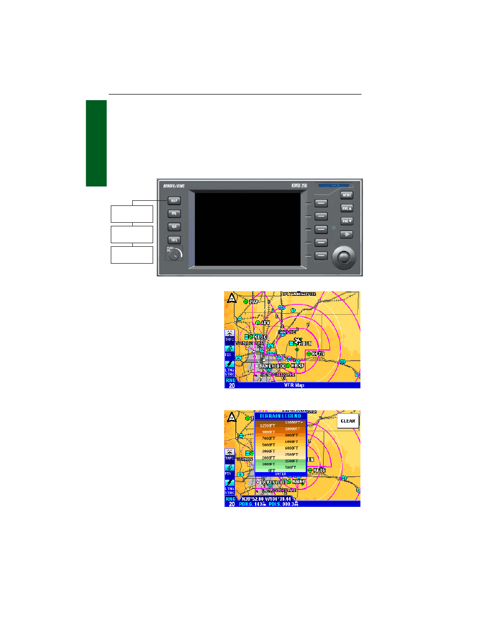
SELECTING A MAP DISPLAY
Press the MAP Function Select Key to sequence through the VFR Map,
IFR Map and Relative Terrain Map Display. With the IFR Map displayed,
no topographic data is displayed. With the Relative Terrain Map dis-
played, topographic data is displayed as colors corresponding to eleva-
tion relative to the aircraft’s present altitude. See Tables 1-1 and 1-2 on
Absolute and Relative Altitudes.
VFR MAP
With the VFR Map displayed,
topographic data is displayed
as colors corresponding to the
absolute altitude stored in the
database (see Figure 1-14).
The VFR Map displays terrain
similar to a VFR sectional
chart. Table 1-1 shows the
levels and terrain shading used
on the VFR Map.
A color key can be displayed
by moving the Joystick Pointer
pressing the LEGEND Softkey
as shown in Figure 1-15. To
exit, press the CLEAR Softkey
then press the RESET STICK
Softkey.
Figure 1-14 - VFR Map
Figure 1-15
Absolute Terrain Color Key
☞
Relative Terrain
Map
VFR Map
IFR Map
- AV8OR (368 pages)
- AV8OR (2 pages)
- AV8OR Ace - Users Guide (419 pages)
- AV8OR Ace - Quick Reference Guide (2 pages)
- AV8OR 3D (16 pages)
- AV8OR 3D (78 pages)
- CAS 66A (57 pages)
- CAS 67A ACAS II (111 pages)
- CAS 67A TCAS II (86 pages)
- CNI 5000 (17 pages)
- EFS 50 System EFS 40/50 (177 pages)
- SG 464 System EFS 40/50 (232 pages)
- KAC 503 System FIS (136 pages)
- KAC 502 System KMD 550 (23 pages)
- KAC 504 System KMD 550 (33 pages)
- KAC 501 System KMD 850 (21 pages)
- KAC 503 - Supplemental System FIS (51 pages)
- FPI 3501B System FPD 500 (65 pages)
- GC 360A (26 pages)
- KA 35 System GOLD CROWN AVIONICS (50 pages)
- KAP 140 (102 pages)
- KC 225 System KFC 225 (42 pages)
- KFC 500 (67 pages)
- KFC 500 (44 pages)
- KFC 500 (45 pages)
- KFD 840 (101 pages)
- KGP 560 (37 pages)
- KHF 1050 (33 pages)
- KCU 951 System KHF 950 (202 pages)
- KLN 35A - Pilots Guide System KLN 35A (179 pages)
- KLN 35A - Quick Reference Guide System KLN 35A (6 pages)
- KLN 89 - Pilots Guide (246 pages)
- KLN 89 - Quick Reference Guide (6 pages)
- KLN 89 - Addendum (1 page)
- KLN 900 - Pilots Guide (224 pages)
- KLN 900 - Abbreviated Guide (57 pages)
- KLN 900 - Memory Jogger (6 pages)
- KLN 90B - Memory Jogger (6 pages)
- KLN 94 - Pilots Guide (284 pages)
- KLN 94 - Quick Reference Guide (8 pages)
- KLR 10 (39 pages)
- KLX 100 - Users Guide (2 pages)
- KLX 135 - Pilots Guide (142 pages)
- KLX 135 - Quick Reference Guide (6 pages)
- KLX 135A - Quick Reference Guide (6 pages)