10 vor page, 11 user waypoint page – Garmin GPS 500 User Manual
Page 115
GPS 500 Pilot’s Guide and Reference
6-17
SECTION 6
WPT PAGES
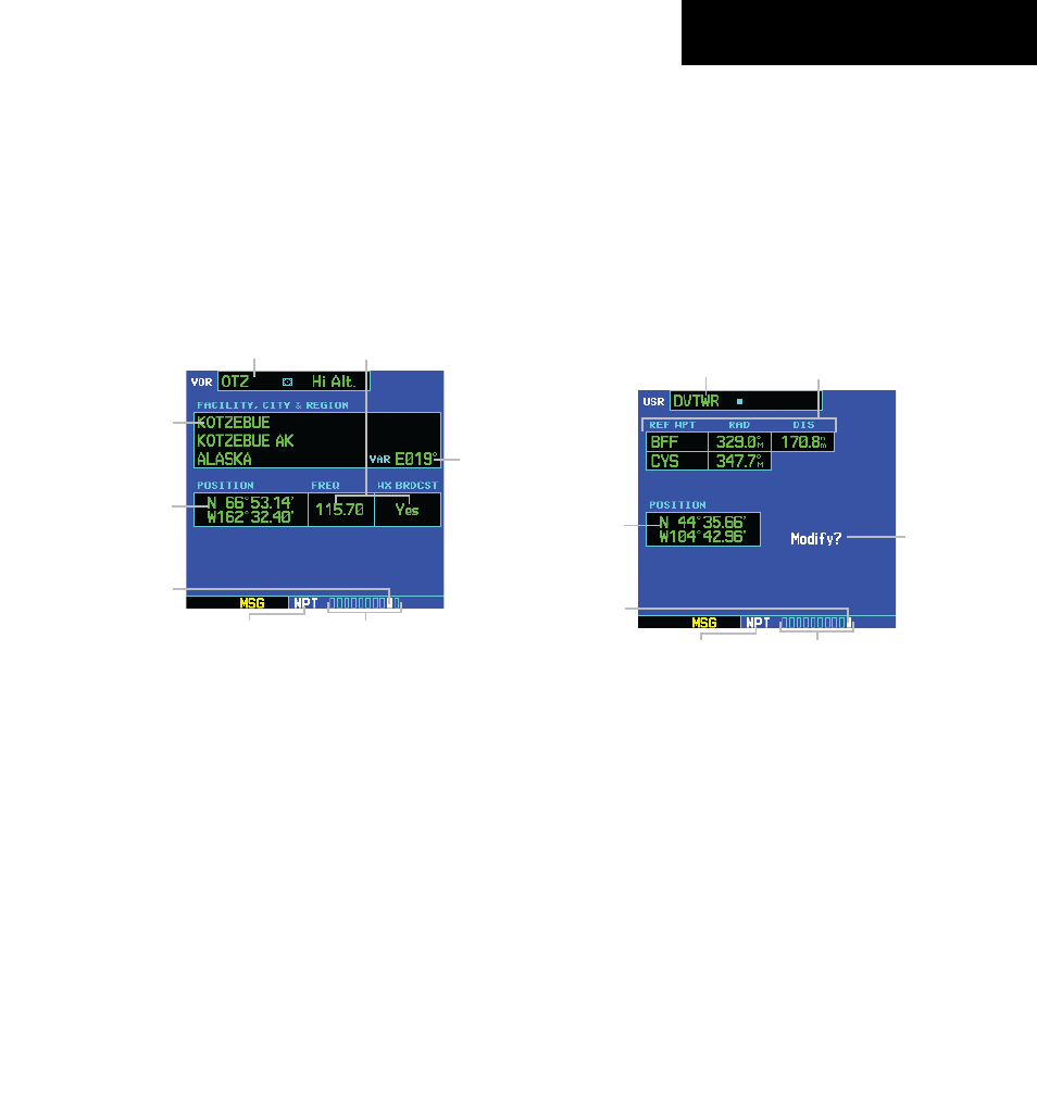
6.10 VOR PAGE
The VOR Page (Figure 6-33) displays the facility
name, city, region/country, magnetic variation, latitude,
and longitude for the selected VOR. The VOR Page also
displays the frequency and a weather broadcast indication
(if applicable).
As mentioned in Section 6.1, VORs may be selected by
identifier, facility name, or location (city).
Figure 6-33 VOR Page
Magnetic
Variation
VOR Identifier
and Symbol
Facility
Name, City,
and Region/
Country
Frequency and Weather
Broadcast Indication
Latitude/
Longitude
Position
Number of Pages in
Current Page Group
Position of
Current Page
within Current
Page Group
Current
Page Group
The following descriptions and abbreviations are
used:
• Symbol - See Section 2.4 for a graphic illustration
of available VOR symbols
• VAR - Magnetic variation in degrees
• Position - Latitude/Longitude (degrees/minutes or
degrees/minutes/seconds), MGRS, or UTM/UPS
• FREQ - Frequency in megahertz (MHz)
• Wx Brdcst - Weather information is broadcast on
the selected facility’s frequency
6.11 USER WAyPOINT PAGE
In addition to the airport, VOR, NDB, and intersection
information contained in the Jeppesen NavData card,
the GPS 500 allows the pilot to store up to 1,000 user-
defined waypoints. The User Waypoint Page (Figure
6-34) displays the waypoint name (up to five characters
long), identifier, radial from two reference waypoints, and
distance from one reference waypoint, along with the user
waypoint’s latitude/longitude position.
Figure 6-34 User Waypoint Page
User Waypoint
Name
Reference Waypoint
Information
Create/
Modify
Action
Field
Latitude/
Longitude
Position
Number of Pages in
Current Page Group
Position of
Current Page
within Current
Page Group
Current
Page Group
The following descriptions and abbreviations appear
on the User Waypoint Page:
• REF WPT - Reference waypoint identifier (name)
• RAD - Radial from reference waypoint, in degrees
magnetic or degrees true (depending upon unit
configuration)
• DIS - Distance from reference waypoint, in
nautical miles/statute miles/kilometers (depending
upon unit configuration)
• Position - Latitude/Longitude (degrees/minutes or
degrees/minutes/seconds), MGRS, or UTM/UPS
190-00181-60 Rev. G