7 ground station, 1 ground station gui, 1 ground station gui 42 – DJI Phantom 2 Vision Plus User Manual User Manual
Page 42
DJI VISION App Usage
42
©
2014 DJI. All Rights Reserved.
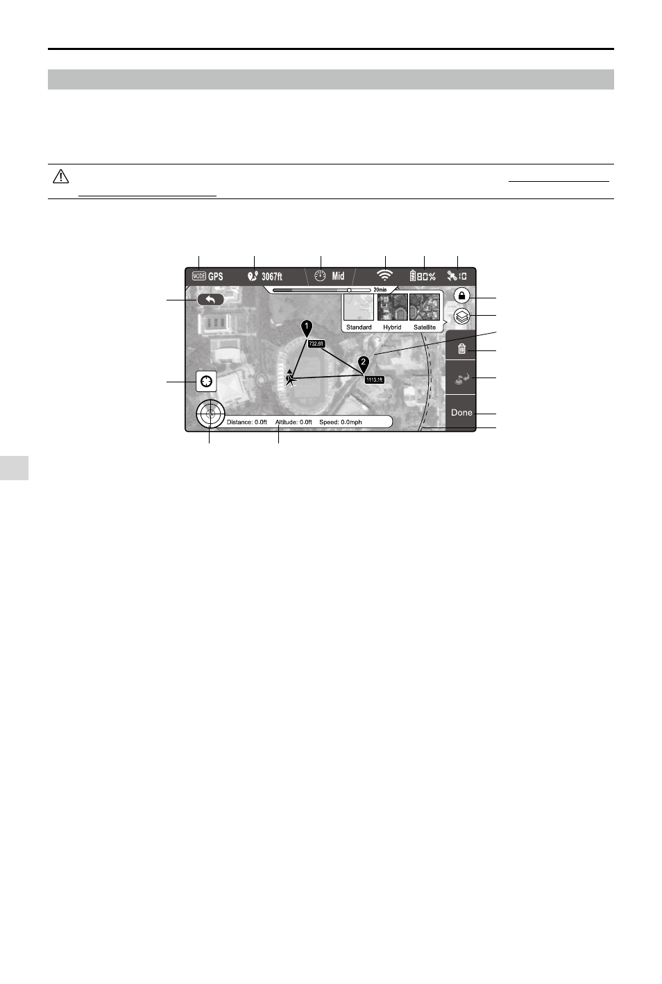
Figure 99
7 Ground Station
The DJI Vision app features an integrated ground station function. Using it you can create flight missions by placing
waypoints and setting waypoint altitude and overall speed. When flight plan has been created, simply tap “GO” and
your aircraft will execute the flight mission automatically. You may also abort the flight mission and bring aircraft home by
activating ”GoHome” feature.
Upgrade Phantom firmware to the latest version to enable ground station feature. Refer to “Firmware Upgrade of
the Phantom 2 Vision+” (P46) for more information about how to upgrade the firmware.
7.1 Ground Station GUI
[1] MODE
Modes include
Hover: Hovering
Waypoint: Mission in progress
GoHome: Returning to home point
Take off: Taking off
Landing: Landing
GPS: GPS flight
Atti.: Atti. flight
Manual: Manual flight
[2] Approximated Flight Mission Distance
Planned mission distance. To achieve optimum battery
performance, max mission distance is 5km(3miles).
[3] Speed
For flight safety concern, only three gears of
flight speed are available. Choose from Fast (8m/
s), Mid(4m/s) and Slow (2m/s) for flight speeds.
Estimated 10 minutes flight is achievable when the
aircraft travels in “Fast” gear.
[4] Wi-Fi Signal Strength
Wi-Fi signal strength display. Refer to [5] in “Using the
DJI Vision App” for details.
[5] Battery Level
Battery level display. Refer to [6] in “Using the DJI
Vision app” for details.
[6] GPS
Number of satellites connected. Refer to [7] in “Using
the DJI Vision app” for details.
[7] Flight Attitude and Radar
Attitude and Radar display. Refer to [3] in “Using the
DJI Vision app” for details.
[8] Flight Parameters
Flight information display. Refer to [4] in “Using the
DJI Vision app” for details.
[9] Back
Return to camera GUI.
[10] Home Point Locator
Locate your Home point.
[11] Orientation Lock
Unlock to sync map orientation with aircraft movement.
[12] Map View
Select map view from standard, hybrid or satellite.
[13] Waypoint
Tap each waypoint to set altitude.
[14] Delete
Delete current waypoint.
[15] Go Home
Abort mission, return home and land.
[16] Done
Hit “Done” then tap “GO” to begin mission.
[17] Flight Area
The aircraft can fly in this area and return to the
home point with the current battery level. This area
is dependent on the current state of the aircraft and
will be refreshed at specific time intervals.
Ground Station
[1]
[2]
[3]
[4]
[5]
[6]
[7]
[8]
[9]
[10]
[11]
[12]
[13]
[14]
[15]
[16]
[17]