Flytec 6030 * User Manual
Page 16
Flytec 6030-GPS
16 / 62
2.6 Navigation
Navigation activities without operating GPS-Receivers is unthinkable these days.
Indeed a chain of satellites is orbiting the Globe. It provides the possibility to determine
world-wide one’s own position very precisely, if min. 4 satellites are received simultaneously.
2.6.1 Assessment of Reception quality
The FLYTEC 6030 GPS is fitted with a 16-channel GPS-Receiver which is featured with
lesser power consumption and also a significantly shorter satellite detection time.
Precision is between 7 to 40m. As an average one may assume approx. 20 m.
Normally the instrument recognises its position under unobstructed view condition after
maximum 1 to 2 minutes. If the receiver is switched-off for a short time (less than 2 hrs.),
the time for new position finding is less than 10 seconds as a rule. Buildings, mountains or
thick forest affect reception quality of the receiver. Therefore, you should always look for the
best possible visibility around you and the antenna in the casing should point upwards
if applicable. In particular when mounted on the steering holder of the hangglider,
we recommend not to have the instrument fixed under the pilot’s head on the middle of
the basis, but indeed sideways. In this position the FLYTEC 6030 GPS should not have more
than 45° deviation from horizontal position so that the antenna points upwards.
Because the receiving strength of the satellite signals is only approx. 1/1000 of mobile
radios, these radio sets and other disruptive factors (like notebooks) should be operated as
far away as possible from the FLYTEC 6030 GPS.
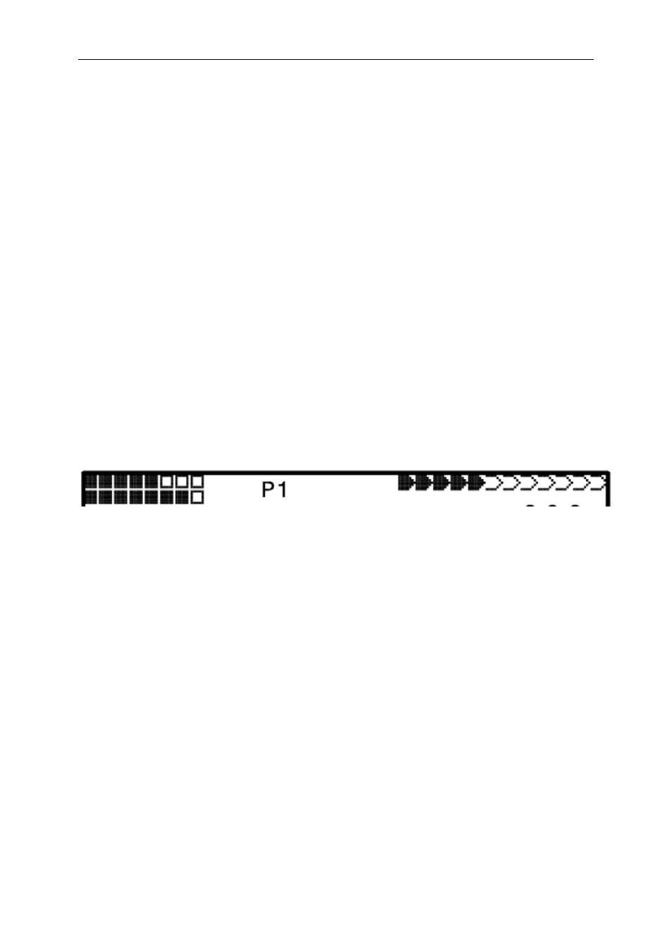
The number of received satellites is shown on the upper right side of the bar scale. The
longer the bar, the more precise is the reception quality.
As soon as the instrument has sufficient GPS reception after energising, the date and time
of day is recorded into the internal memory. This action is signalled by the instrument with a
slight beep tone.
2.6.2 Compass and Flight Direction
In contrast to a normal magnetic compass which is oriented to the magnetic lines of force of
the Globe, the GPS compass can show direction only when the user moves about.
However, it has the advantage that it is not subject to any grid deviation and does not show
any deviation as a result of iron or any magnetic material either. Its zero point always
corresponds with true geographic north (0 or 360 degrees).
The course that is the flight direction (= Track), is calculated from a series of positions. If the
user remains stationary at the same location, then the course (track) and compass needles
are undefined. The exact course, this is the direction in which the user travels over ground, is
always at the top of the compass, but can also be read in the display “Track”. When circling
in a thermal the compass rose only appears to turn; in reality the needle does not move; it’s
the casing along with the aircraft, which moves around the rose.
2.6.3 Track and Bearing
In accordance to previous GPS receivers, the Track is also defined as the route of
movements of the aircraft over ground. Geographic true North is always 0 or 360 degrees
(East = 90, South = 180, West = 270 degrees).