Navigation – NISSAN 2015 Murano - Navigation System Owner's Manual User Manual
Page 88
6. Navigation
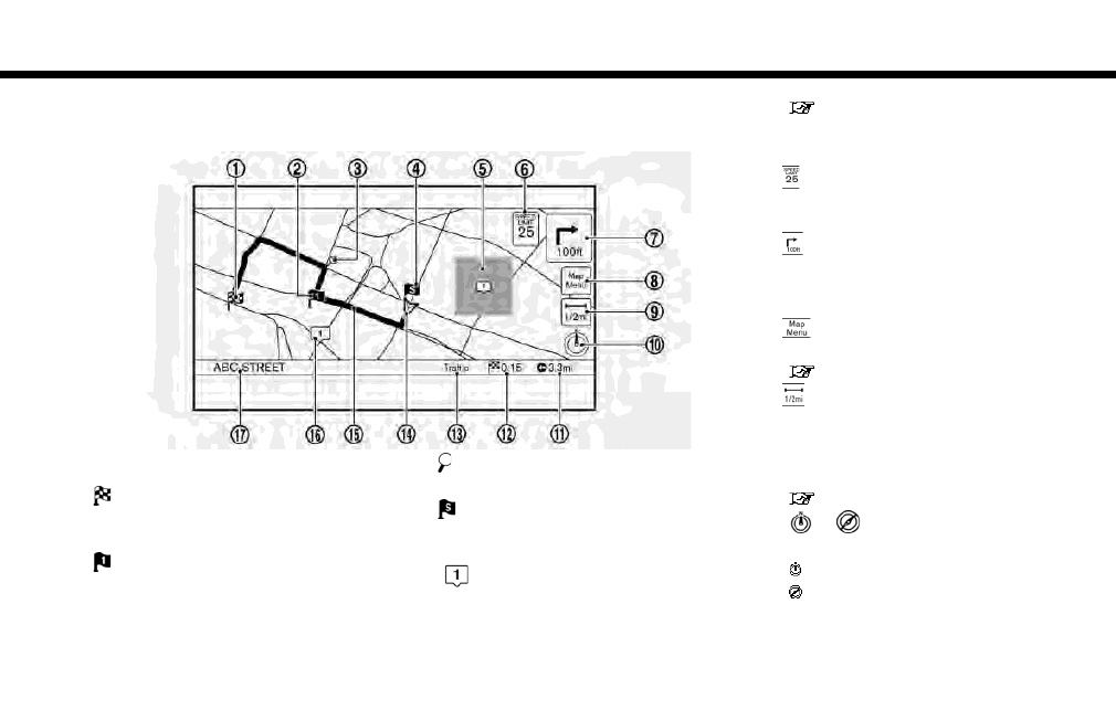
2D map
The 2D map displays the map in a two-dimensional environment similar to a road map.
Screen information:
*
1
Destination:
Indicates the location of the final destina-
tion.
*
2
Waypoint:
Displays the location of the waypoint the
vehicle will stop by before heading to the
final destination. A maximum of 5 waypoints
can be set.
*
3
Guide point:
Indicates a guide point on the route.
*
4
Starting point:
Displays the vehicle location, with which the
route is set, as the starting point.
*
5
Avoid area:
Displays the areas to avoid that are stored in
the Address Book. Route guidance can be
set to avoid the registered avoid areas.
“Storing avoid area” (page 6-47)
Green: Freeways included
Blue: Freeways not included
*
6
Speed limit icon:
Displays the speed limit of the road the
vehicle is on.
*
7
Arrow and distance:
Indicates the distance to the next guide
point and the turning direction at that guide
point.
*
8
icon:
Touch the icon to display the Map Menu.
“Map Menu screen” (page 6-12)
*
9
Scale indicator:
Indicates the scale of the map.
Touch the icon to display the scale bar. The
map scale can be adjusted using the scale
bar.
“Changing scale of map” (page 6-7)
*
10
/
Direction indicator:
Indicates the directional setting of the map.
: North always pointing up.
: Direction of the vehicle heading always
pointing up.
Touch the icon to change the map view and
6-4