Hazard avoidance, Forward looking terrain avoidance – Garmin G1000 Mooney M20TN User Manual
Page 326
Garmin G1000 Pilot’s Guide for the Mooney M20M/M20R/M20TN
190-00647-02 Rev. A
312
HAZARD AVOIDANCE
SY
STEM
O
VER
VIEW
FLIGHT
INSTRUMENTS
EIS
AUDIO P
ANEL
& CNS
FLIGHT
MANA
GEMENT
HAZARD
AV
OID
ANCE
AFCS
ADDITIONAL FEA
TURES
APPENDICES
INDEX
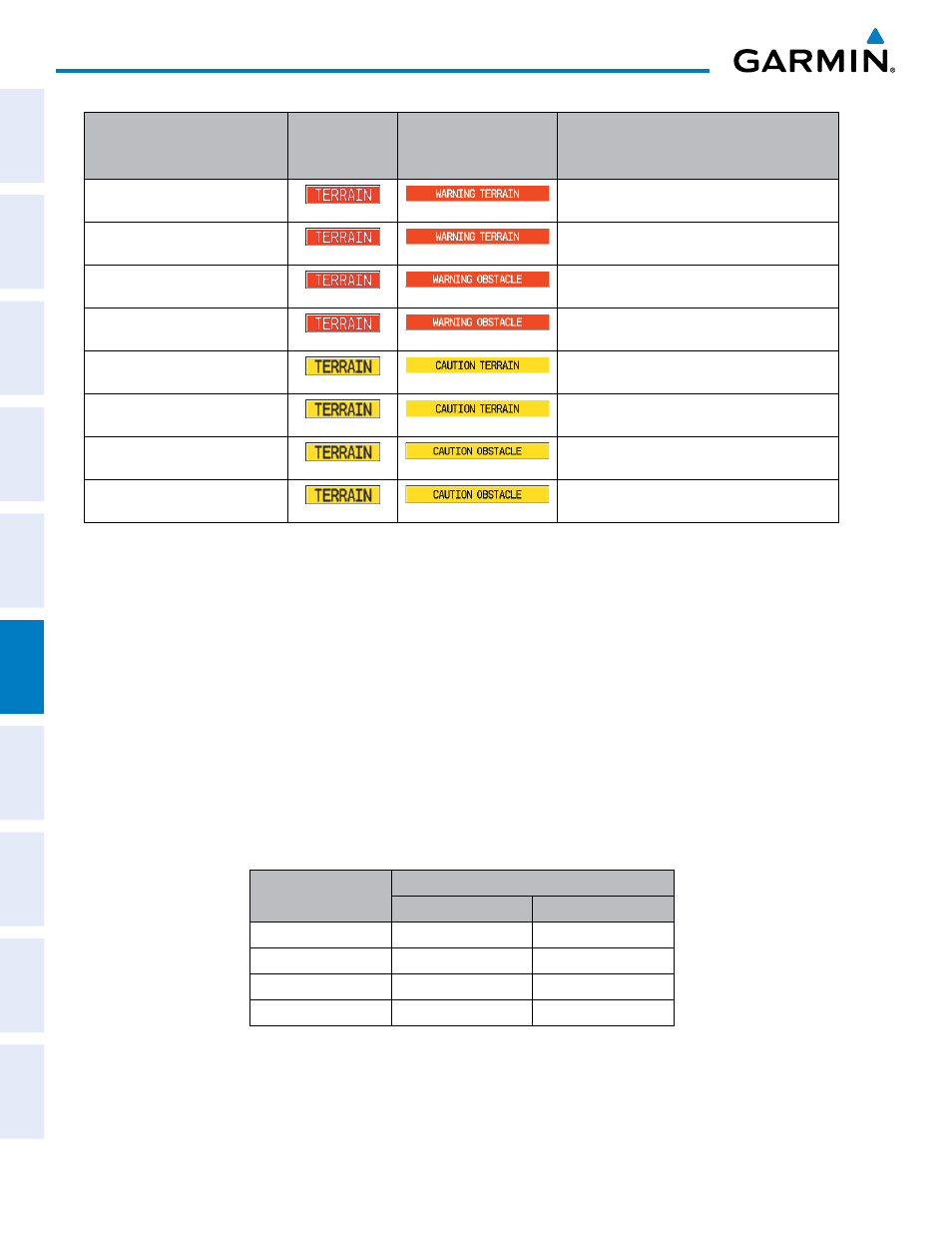
Alert Type
PFD/MFD
Alert
Annunciation
MFD
Pop-Up Alert
Aural Message
Reduced Required Terrain Clearance
Warning (RTC)
“Warning; Terrain, Terrain”
Imminent Terrain Impact Warning (ITI)
“Warning; Terrain, Terrain”
Reduced Required Obstacle Clearance
Warning (ROC)
“Warning; Obstacle, Obstacle”
Imminent Obstacle Impact Warning (IOI)
“Warning; Obstacle, Obstacle”
Reduced Required Terrain Clearance
Caution (RTC)
“Caution; Terrain, Terrain”
Imminent Terrain Impact Caution (ITI)
“Caution; Terrain, Terrain”
Reduced Required Obstacle Clearance
Caution (ROC)
“Caution; Obstacle, Obstacle”
Imminent Obstacle Impact Caution (IOI)
“Caution; Obstacle, Obstacle”
Table 6-6 TERRAIN-SVS Alerts Summary
FORWARD LOOKING TERRAIN AVOIDANCE
Reduced Required Terrain Clearance (RTC) and Reduced Required Obstacle Clearance (ROC)
alerts are issued when the aircraft flight path is above terrain, yet is projected to come within the minimum
clearance values in Table 6-7. When an RTC alert is issued, a potential impact point is displayed on the
TERRAIN-SVS Page.
Imminent Terrain Impact (ITI) and Imminent Obstacle Impact (IOI) alerts are issued when the
aircraft is below the elevation of a terrain or obstacle cell in the aircraft’s projected path. ITI and IOI alerts
are accompanied by a potential impact point displayed on the TERRAIN-SVS Page. The alert is annunciated
when the projected vertical flight path is calculated to come within minimum clearance altitudes in Table
6-7.
Flight Phase
Minimum Clearance Altitude (ft)
Level Flight
Descending
Enroute
700
500
Terminal
350
300
Approach
150
100
Departure
100
100
Table 6-7 FLTA Alert Minimum Terrain and Obstacle Clearance Values