Connecting directly to a gps – Raymarine Marine GPS System User Manual
Page 167
Appendix A – Connecting Peripheral Instruments
A-3
Connecting Directly to a GPS
When connecting Navigator directly to a GPS system, follow these
guidelines:
•
Verify that GPS NMEA output is turned on.
•
Set the GPS datum to WGS84.
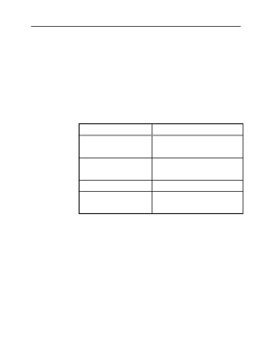
To connect directly to a GPS system, refer to Figure A-1 and Table A-1.
Table A-1. Connecting Navigator Directly to GPS System
Connect Cable Color:
To GPS Lead:
Yellow (Rx)
NMEA + output
(which may also be labeled TX, TX+,
Data out+, or NMEA OUT+)
Blue (SGnd)
NMEA - input
(which may also be labeled RX-,
Data In -, or NMEA IN-, or Ground)
Green (Tx)
Not used
Black (SGnd)
NMEA - output
(which may also be labeled TX-,
Data Out -, or NMEA OUT-, or Ground)
See also other documents in the category Raymarine GPS receiver:
- RAYTHEON E32001 (13 pages)
- RAYCHART 420 (101 pages)
- L365 (83 pages)
- SR50 (48 pages)
- A65 (100 pages)
- RS12 (50 pages)
- DSM300 (82 pages)
- NMEA Multiplexer (16 pages)
- Pathfinder (111 pages)
- Pathfinder Radar (244 pages)
- autopilot control unit (111 pages)
- VolvoPenta IPS Autopilot System DPU (16 pages)
- autopilot + ST4000+ (145 pages)
- stand-alone master instrument (45 pages)
- ST80 (15 pages)
- Raystar 125 (8 pages)
- RS12 (38 pages)
- ST6001 (48 pages)
- Pathfinder Radar Scanners (66 pages)
- Chartplotter (101 pages)
- Heading Sensor (24 pages)
- Ray430 (54 pages)
- Viewable Marine Displays (38 pages)
- C Series (244 pages)
- ST8001 (48 pages)
- hsb2 PLUS Series (246 pages)
- 631 PLUS (170 pages)
- navigation system (17 pages)
- ST8002 (48 pages)
- PowerPilot (18 pages)
- ST7002 (52 pages)
- GPS Kit (24 pages)
- 465 (107 pages)
- Ray54E (116 pages)
- GPS Plotter (131 pages)
- GPS navigation (75 pages)
- ST7001 (48 pages)
- 300 (136 pages)
- Raystar 120 (30 pages)
- autopilot (137 pages)
- DSM30 (34 pages)
- Platinum Chart Card (29 pages)
- ST6002 (56 pages)
- 320 (139 pages)