Icon name description field operations – Ag Leader SMS Mobile Icons/Buttons Quick Start Guide User Manual
Page 8
SMS Mobile Buttons
Revision 8/1/2013 © 2013 Ag Leader Technology, Inc All Rights Reserved
7
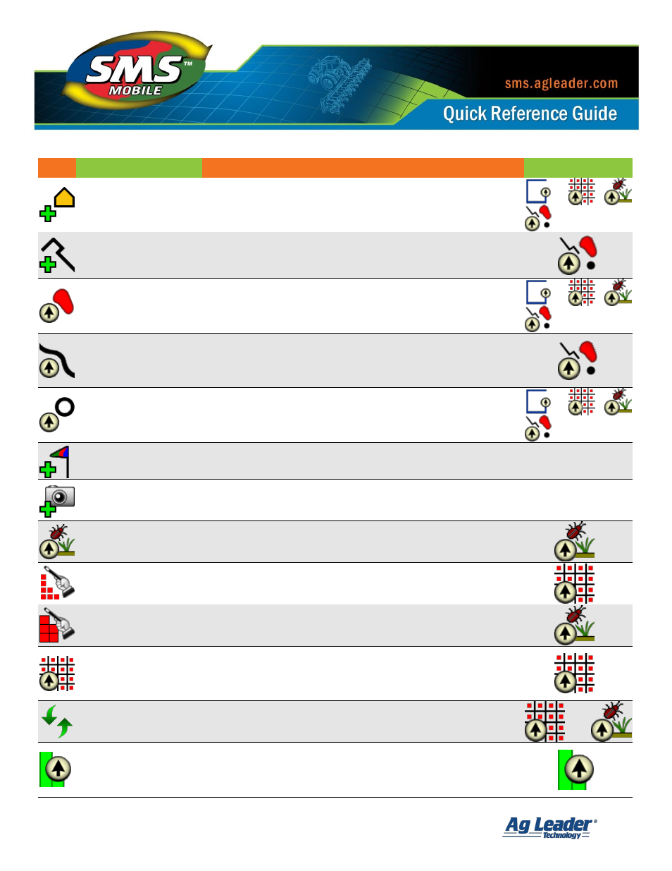
Icon
Name
Description
Field Operations
Add Polygon
Allows the addition of a polygon(s) by manually adding the
points/vertices that define the polygons shape. When hand
drawing polygons this is the common method to use.
Add Polyline
Allows the addition of a line by manually adding the segment
start and end points. When hand drawing lines this is the
common method to use.
Add Freehand Polygon
Allows the addition of a polygon based on where you drive or
draw on the screen. The polygon is created automatically and
no manual addition of vertices is needed. When using GPS,
this is the most common way to create a polygon.
Add Freehand Polyline
Allows the addition of a line based on where you drive or draw
on the screen. The line is created automatically and no manual
addition of vertices is needed. When using GPS, this is the most
common way to create a line.
Add Circle
Allows the addition of a circle based on your GPS position or
by drawing on the screen.
Add Landmark Note
Allows you to add a Landmark Note. Landmark Notes can
only be added when you aren’t logging/creating data.
All
Add Layer/Picture Note
Allows you to add a Layer/Picture Note. Picture Notes
can also be added for specific Pests when creating a
Scouting Observation.
All
Start Scouting
Allows you to scout new or existing regions.
Create Samples
Wizard process that creates a soil sampling dataset that is
either point, grid, or region based.
Create Scouting
Observations
Wizard process that creates scouting observation regions.
Scouting observations have to have a coverage area, they
cannot be points or line.
Take Samples
Guides you through sampling a selected soil sampling dataset.
Provides guidance to the next sample site based on order or
closest sample site. Also keeps track of which sites you have
been to so you don’t get guided to the same site twice.
Reset Samples /
Observations
Resets the tracking of sites that have been sampled when
using the Take Samples tool in Soil Sampling Mode or the
Start Scouting tool in Crop Scouting Mode.
Log Coverage
Starts the coverage logging tool which will allow collecting of
swath based data based on the selected logging interval and
minimum travel distance. The coverage points are logged
automatically based on GPS.