Messages and configuration commands – Seiwa Si-Tex Vector 3D GPS User Manual
Page 27
30
27
Chapter 3: Operation
Messages and Configuration Commands
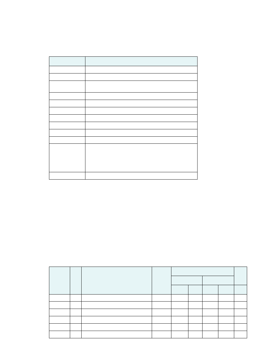
Table 3-2: Commands
Command
Description
$JAGE
Specify maximum DGPS (COAST) correction age (6 to 8100 seconds)
$JAPP
Query or specify receiver application firmware
$JASC
Specify ASCII messages to output to specific ports (see ASCII messages
in Table 3-3)
$JBAUD
Specify RS-232 (output) communication rate
$JBIN
Specify binary messages to output to specific ports (see Table 3-4)
$JDIFF
Query or specify differential correction mode
$JGEO
Query or specify SBAS for current location and SBAS satellites
$JI
Query unit’s serial number and firmware versions
$JOFF
Turn off all data messages
$JQUERY,GUIDE
Query accuracy suitability for navigation
$JRESET
Reset unit’s configuration to firmware defaults
Note: $JRESET clears all parameters. For the
3D
you will have to issue
the $JATT, FLIPBRD,YES command to properly redefine the circuitry
orientation inside the product once the receiver has reset. Failure to do so
will cause radical heading behavior.
$JSAVE
Save session’s configuration changes
NMEA Output
The following NMEA 0183 & proprietary data output messages are the ones most commonly used on the Vector 3D (for
others, see the next 3 pages). Factory enabled messages are shown in Grey, and the default repeat rate is shown in the
default column. Factory disabled sentences are shown with an X. Once the Vector 3D is installed and setup correctly,
record in the User column any changes you made for future reference.
In Table 3-3 the Info Type value is one of the following:
•
P = Position
•
V = Velocity, Time
•
H = Heading, Attitude
•
S = Sats, Stats, Quality
Table 3-3: NMEA 0183 and other messages
Message
Info
Type
Description
IEC
Approved
Message
Enabled
Max
Rate
Port A
Port C
Default
User
Default
User
$GPDTM
P
Datum reference
Yes
X
X
1
$GPGGA
P
GPS position and fix data
Yes
X
X
20**
$GPGLL
P
Geographic position - lat/long
Yes
1
X
20**
$GPGNS
P
GNSS position and fix data
Yes
X
X
20**
$GPGRS
S
GNSS range residual (RAIM)
Yes
X
X
20**
$GPGSA
S
GNSS DOP and active satellites
Yes
X
X
1