Traffic map page, Hazard avoidance – Garmin G1000 Quest Kodiak User Manual
Page 347
190-00590-03 Rev. A
Garmin G1000 Pilot’s Guide for the Quest KODIAK 100
SY
STEM
O
VER
VIEW
FLIGHT
INSTRUMENTS
EIS
AUDIO P
ANEL
& CNS
FLIGHT
MANA
GEMENT
HAZARD
AV
OID
ANCE
AFCS
ADDITIONAL
FEA
TURES
APPENDICES
INDEX
335
HAZARD AVOIDANCE
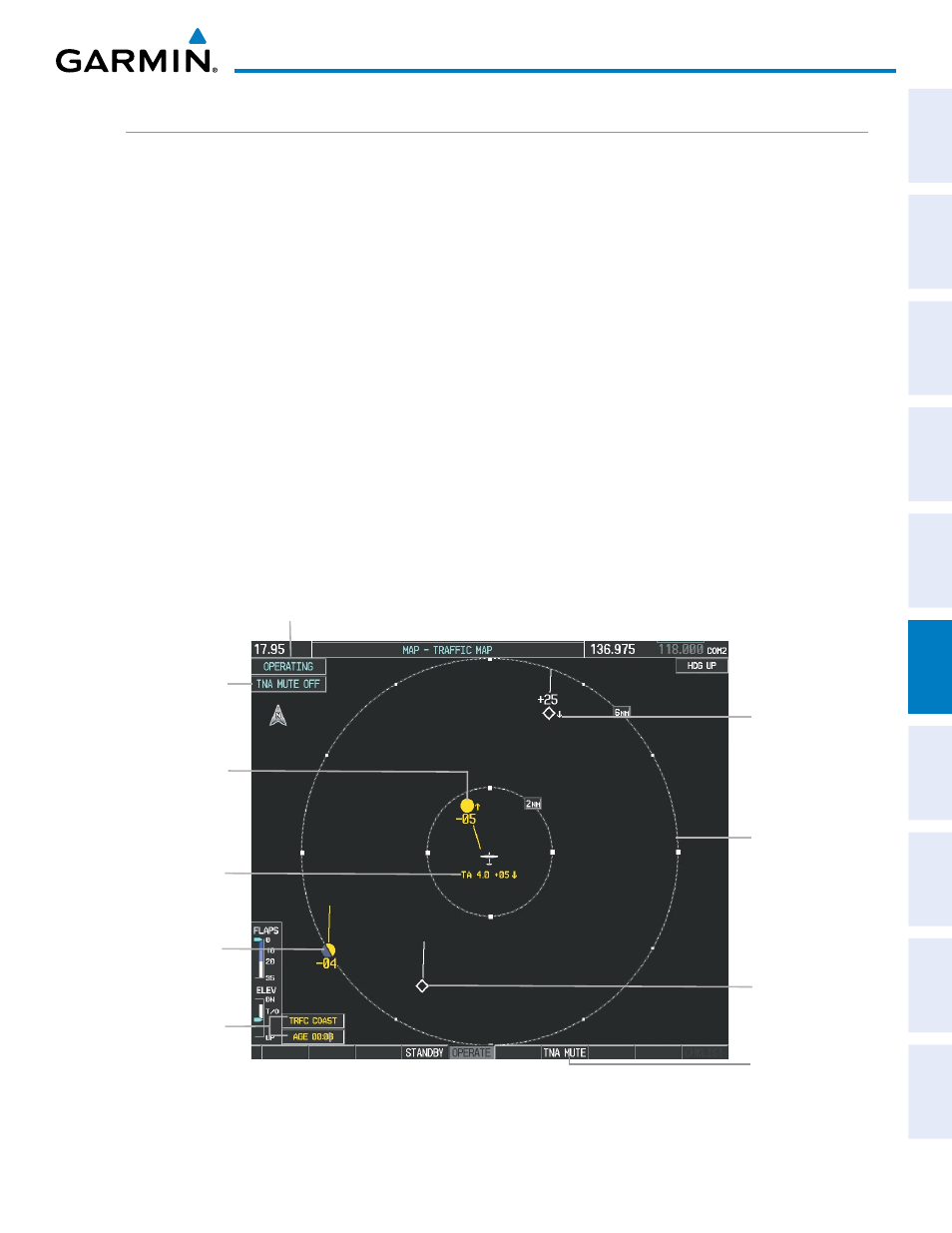
TRAFFIC MAP PAGE
The Traffic Map Page is specialized to show surrounding TIS traffic data in relation to the aircraft’s current
position and altitude, without clutter from the basemap. Aircraft orientation on this map is always heading up
unless there is no valid heading. Map range is adjustable with the RANGE Knob from 2 to 12 nm, as indicated
by the map range rings.
The traffic mode is annunciated in the upper left corner of the Traffic Map Page. When the aircraft is on the
ground, TIS automatically enters Standby Mode. Once the aircraft is airborne, TIS switches from Standby to
Operating Mode and the G1000 begins to display traffic information. Refer to the System Status discussion for
more information.
Displaying traffic on the Traffic Map Page:
1)
Turn the large FMS Knob to select the Map Page Group.
2)
Turn the small FMS Knob to select the Traffic Map Page.
3)
Confirm TIS is in Operating Mode:
Press the OPERATE Softkey to begin displaying traffic.
Or
:
a)
Press the MENU Key.
b)
Select ‘Operate Mode’ (shown if TIS is in Standby Mode) and press the ENT Key.
Figure 6-71 Traffic Map Page
Non-Threat
Traffic, 2500’
Above,
Descending
“Non-Bearing” Traffic
(System Unable to
Determine Bearing)
Distance is 4.0 nm,
500’ Above,
Descending
Non-Threat
Traffic,
Altitude Not
Reported
Traffic Advisory
Off Scale
400’ Below, Level
Traffic Status
Banners
Traffic Mode Annunciation
“TIS Not Available”
Voice Alert Status
Range
Marking
Ring
Select
to Mute
“TIS Not
Available”
Voice Alert
Traffic Advisory, 500’
Below, Climbing