Byte offset, Name, Format – Moog Crossbow GNAV540 User Manual
Page 81: Scaling, Units, Description, Table 52 n3 payload
V540
Manual
080
Rev. B
Page 81
GNA
7430‐
User
8‐01
This packet contains navigation data and selected sensor data scaled in most cases to a signed 2^16 2’s complement
number. Data involving angular measurements include the factor pi in the scaling and can be interpreted in either
radians or degrees.
• Angles: scaled to a range of (‐pi, +pi) or (‐180 deg to +180 deg)
•
(‐630 deg/sec to +630 deg/sec)
Angular rates: scaled to range of 3.5* (‐pi,+pi) or
• Accelerometers: scaled to a range of (‐10,+10) g
• Temperature: scaled to a range of (‐100, +100) °C
• GPS Velocities: scaled to a range of (‐256,256) m/s
•
epresentation.
Altitude: scaled to a range of (‐100, 16284) m using a shifted 2’s complement r
•
deg)
Longitude and latitude: scaled to a range of (‐pi, pi) or (‐180 deg to +180
• GPS heading are scaled to a range of (‐pi, +pi) or (‐180 deg to +180 deg)
• The GPS velocity components are directly from GPS measurements. No inertial Measurements are involved
in its computation.
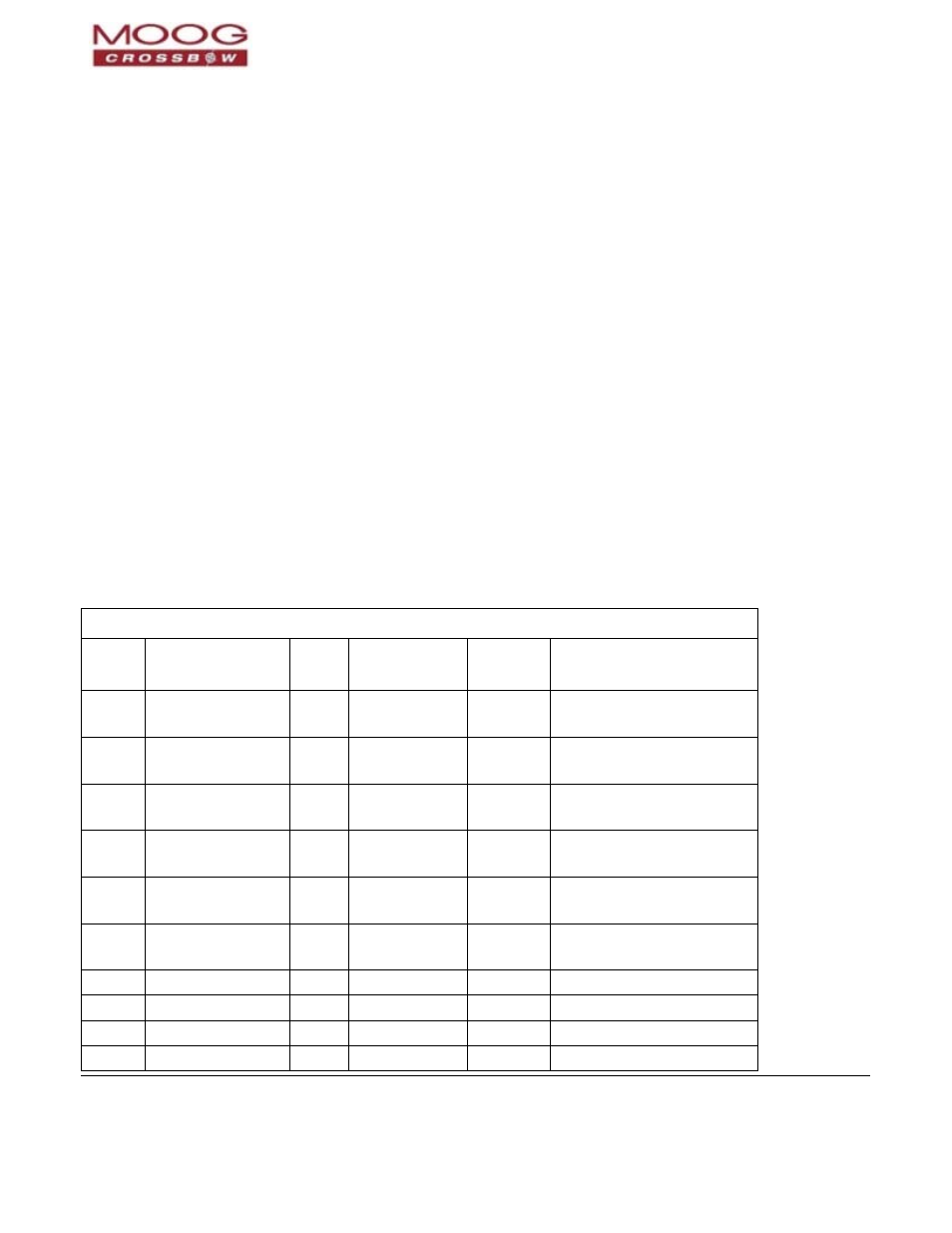
Table 52 N3 Payload
N3 Payload Contents
Byte
fset
Of
Name
Form
at
Scaling
Units
Description
0
rollAngle
I2
2*pi/2^16
)
(360°/2^16
Radians
(°)
Roll angle
2
pitchAngle
I2
2*pi/2^16
)
(360°/2^16
Radians
(°)
Pitch angle
4
yawAngleTrue
I2
2*pi/2^16
)
(360°/2^16
Radians
(°)
Yaw angle (true north)
6
xRateCorrected
I2
7*pi/2^16
6)
(1260°/2^1
rad/s
)
(°/sec
X angular rate corrected
8
yRateCorrected
I2
7*pi/2^16
6)
(1260°/2^1
rad/s
)
(°/sec
Y angular rate corrected
10
zRateCorrected
I2
7*pi/2^16
^16)
(1260°/2
rad/s
/sec)
(°
Z angular rate corrected
12
xAccel
I2
20/2^16
g
X accelerometer
14
yAccel
I2
20/2^16
g
Y accelerometer
16
zAccel
I2
20/2^16
g
Z accelerometer
18
nVel
I2
512/2^16
m/s
GPS North velocity