DeLorme PN-20 User Manual
Page 27
26
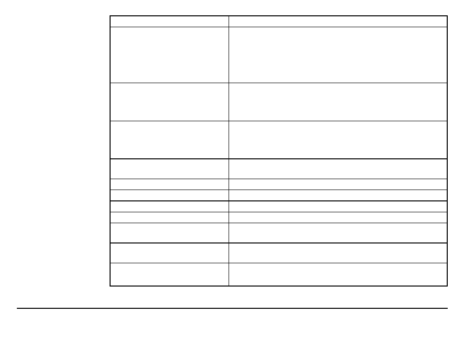
Information Field Option
Description
Bearing
The direction of travel from the current location to the desti-
nation (finish or next stop). Expressed in degrees. Displays
a green arrow pointing in the direction of the next waypoint
or route point. The arrow is grayed out when no movement
is reported by the device. It is green when the device is
moving.
Coordinates: Primary
The coordinates for the current GPS location, cursor position,
or map center in the primary format. The default is Lat/
Lon. You can change the format in Device Setup>
Units>Coordinates: Primary.
Coordinates: Secondary
The coordinates for the current GPS location, cursor position,
or map center in the secondary format. The default is
UTM/UPS. You can change the format in Device Setup>
Units>Coordinates: Secondary.
Course
The direction of travel on a route from the starting location to
the destination (finish or next stop). Expressed in degrees.
Device Odometer
The total distance traveled in all trips.
Distance to Finish
The distance from the current location to the route finish.
Distance to Next Stop
The distance from the current location to the next stop in the route.
Distance to Next Turn
The distance from the current location to the next turn in the route.
Elevation
The altitude (height) above or below sea level. Expressed in
distance.
Elevation: Maximum
The maximum elevation achieved. Expressed in distance.
This field may be reset when you clear Trip Info.
Elevation: Minimum
The minimum elevation achieved. Expressed in distance.
This field may be reset when you clear Trip Info.