Aprs- display example – Kenwood RC-D710 User Manual
Page 41
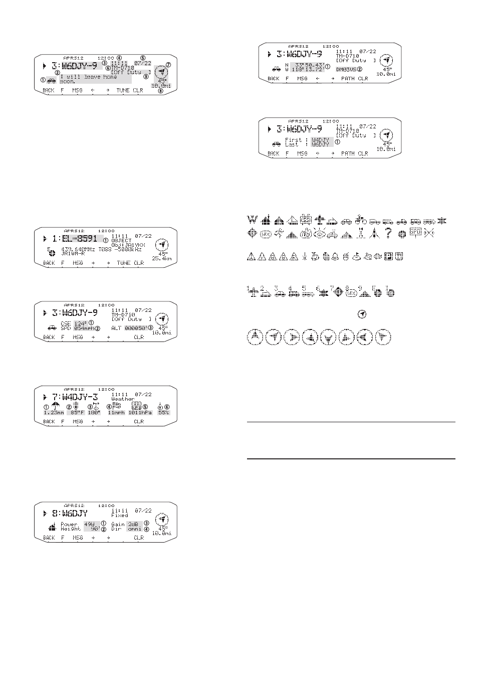
APRS-
DiSPlAy exAmPle
Page 1
q
: Station icon
w
: Status text
e
: Call sign
r
: Time (packet received)
t
: Date
y
: Situation
u
: Direction of station
i
: Distance from station (mile or km)
o
: Position comment
1
1
For packets received from Mic-encoder stations including
TM-D710s (or RC-D710), TM-D700s and TH-D7s, position
comments are displayed in the fourth line.
(Object)
q
: Object
Page 2
(Mobile station)
q
: Moving direction
w
: Moving speed (mph: Mile/hour or kph: km/hour)
e
: Altitude (' :Feet or M: Meter)
(Weather station)
q
: Rainfall (" or mm)
w
: Air temperature
e
: Wind direction
r
: Wind velocity (mph: Mile/hour or kph: km/hour)
t
: Atmospheric pressure
y
: Humidity
(Fix station)
q
: Transmit power
w
: Height of antenna (elevation) (' : Feet or M: Meter)
e
: Antenna gain
r
: Antenna directivity
Page 3
q
: Position data
w
: Grid square locator
(Packet path)
q
: Call sign (Digipeater)
This transceiver is capable of displaying the following
icons as station IDs.
Some icons may appear with overlay characters as below
if the received icon data includes them.
The following icons show the directions of stations relative
to your position. For example, “ ” indicates the other
station is located at the northeast relative to your position.
0.0 to 9999 miles (or km) are shown for distances from
other stations. “xxxxmi” (or “xxxxkm”) is shown for
distances over 9999 miles (or km).
To change the speed/distance and/or temperature
settings of the units, access Menu 626 (DISPLAY UNIT 1
- SPEED, DISTANCE) and/or Menu 626 (DISPLAY UNIT
1 -TEMPERATURE)
Note: Some stations transmit APRS packets through TNCs
connected to GPS receivers. If you receive packets from those
stations, “GOOD” (satellites tracked) or “LAST” (satellites not tracked)
will be shown as the situation, with GLL, GGA, or RMC which
designates $GPGLL, $GPGGA, or $GPRMC format.