GME GP450XB User Manual
Page 5
GP450X
INSTRUCTION MANUAL
PAGE 5
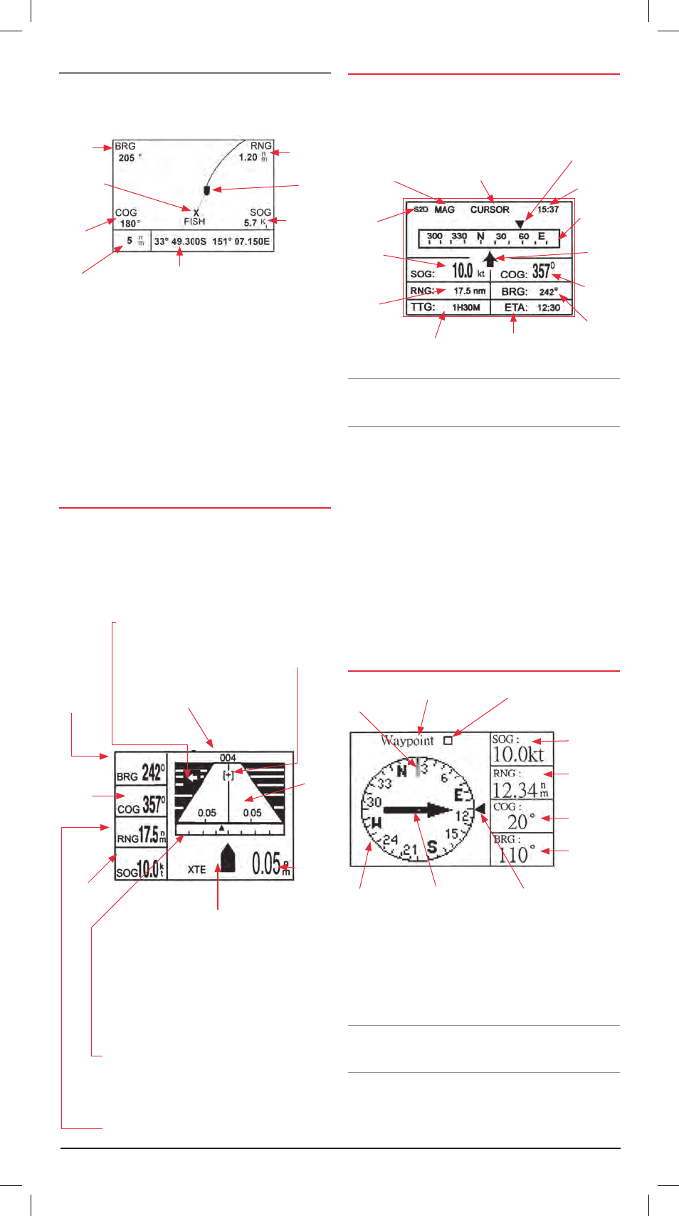
Plotter display
The plotter display shows your ships position, track history,
bearing and range to target, course and speed over ground and
zoom range .
The Plotter page allows you to view your current location . It also
displays a record of your track along with nearby Waypoints . The
‘ship’ on the screen shows your present position and heading
(the bow of the ship points in the direction of travel . At the
corners of the screen are displayed the Bearing (BRG), Range
(RNG), Course over Ground (COG) and Speed Over Ground
(SOG) relative to your destination . Your present Latitude and
Longitude is displayed at the bottom of the screen .
If the unit is in ‘cursor’ mode, the Latitude and Longitude will
display the position of the cursor on the screen and the BRG
and RNG will display values relative to the cursor .
hIGhWay dIsPlay
The highway display provides a 3D view of your own vessel’s
progress towards a destination (Waypoint), along with
associated navigation data .
NavIGatIoN data dIsPlay
The Navigation display provides a sliding compass scale . The
vessel arrow in the centre shows your vessel’s present compass
heading . The Waypoint Marker shows the direction of your
destination Waypoint relative to your track .
Note: The compass scale requires your vessel to be moving in
order to determine your direction . It does not work while your
vessel is stationary .
The centre of the page features a sliding compass scale that
shows your course over ground (current track) while you are
moving . Your present course over ground is indicated by the
vessel pointer in the centre of the display . A destination marker
shows the Bearing to your destination Waypoint relative to your
current track (COG) . The compass scale and Waypoint marker
work independently to show at a glance the direction of your
movement and direction to your destination .
e .g . if the destination marker is to the left or right of your
vessel’s current track you should steer towards the marker until
it is directly above your vessel’s pointer . Once your vessel’s
pointer is aligned with the destination marker, you are travelling
towards your destination .
comPass dIsPlay
When a destination is set the compass page will guide you to
your destination with digital readouts and a graphic compass
display which includes a bearing pointer . The Compass page is a
good alternative to the highway page when travelling at slower
speeds or when making frequent directional changes such as
when straight line navigation is not possible due to obstructions
or terrain .
Note that the compass page requires your vessel to be moving
in order to determine your direction . It does not work while your
vessel is stationary .
The centre of the page features a rotating compass that shows
your course over ground (current track) while you are moving .
Your present course over ground is indicated at the top of the
compass ring . A Bearing Pointer in the centre of the compass
Bearing
Waypoint
Range to
Target
Vessel
Speed over
Ground
Direction you need to Steer to
return to the correct course .
Appears to the right or left of
the centreline depending on
steering direction required .
Bearing
from your
vessel to
destination
waypoint .
Course over
Ground .
Speed over
ground .
Destination (cursor or waypoint name) .
Highway
Destination
Waypoint
location . Moves
forward as your
vessel nears
its destination .
Analogue Cross Track Error (XTE) Scale .
Arrow shifts with vessels XTE . When the
arrow is aligned with the centreline, the
boat is on course . Arrow blinks if vessel’s
XTE is greater than the XTE scale . ‘N’
(North) is displayed instead of arrow
when no destination is set .
Boat Mark – displays course as follows:
When waypoint is set, arrow shows
boats course towards destination .
When no waypoint is set, mode is North Up and
arrow shows boats course towards destination .
Digital XTE
Receiver
Status .
Speed over
Ground .
Range from
your vessel to
destination .
Time to Go (TTG)
to destination .
Estimated Time of Arrival
(ETA) at destination .
Bearing reference
(Magnetic or True) .
Destination (CURSOR or
Waypoint name) .
Time
Destination
Marker .
Compass
Scale .
Vessel
Bearing
Course
over
Ground .
Course over
Ground marker .
Compass Ring
Bearing Pointer
Bearing Marker
Speed over
Ground .
Range from
vessel to
destination .
Course over
ground .
Bearing to
destination .
Waypoint name
Waypoint Symbol
Ship’s Position when Navigating Cursor
Position when Cursor is displayed .
Range from your vessel to Destination waypoint .
Course over
Ground
Screen
Range