Raymarine hsb2 PLUS Series User Manual
Page 63
Chapter 2: Getting Started & Adjusting the Display
2-31
Di
splaying t
he
R
ad
ar
an
d S
ync
hr
on
iz
in
g
Ra
da
r & C
har
t
f
FIND SHIP
MORE¬
SCREEN
RDR CHRT
GOTO
MORE¬
ROUTE
RDR CHRT
6
5
7
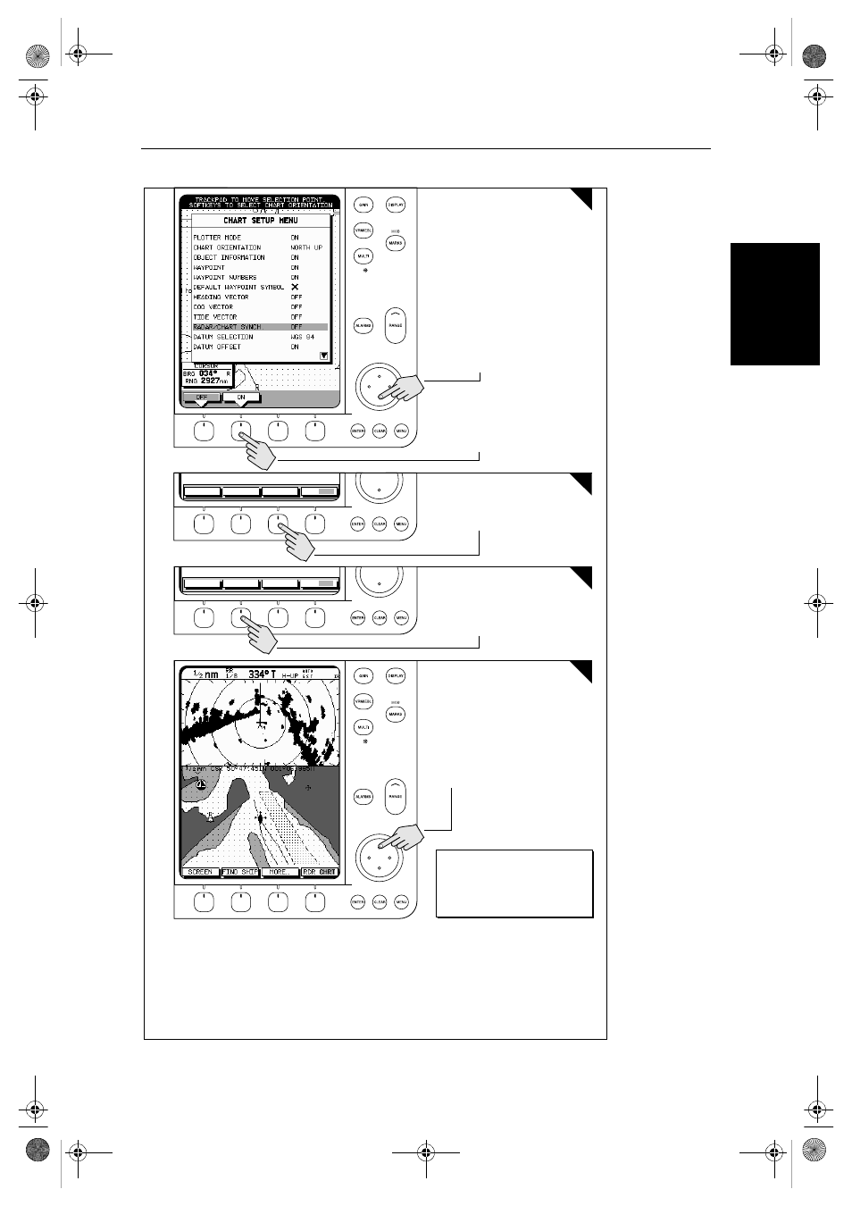
Press the soft key to synchronise the
chart & radar images.
The radar and chart windows are
synchronised and the cursor is
'homed' on the vessel
D4293-1a
Press the soft key.
See:
2.3 Controlling the Display
6.5 Cursor Echo
7.3 System Parameters
7.6 Chart Set Up
4
2. Press the soft key.
3. Press ENTER twice.
1. Move selection bar over
Radar/Chart Synch.
Move the chart cursor -- you can see
chart cursor move on the radar
screen.
You can move the cursor over
a radar target to determine its
identity on the chart
81186_3.book Page 31 Thursday, August 22, 2002 8:23 AM
See also other documents in the category Raymarine GPS receiver:
- RAYTHEON E32001 (13 pages)
- RAYCHART 420 (101 pages)
- L365 (83 pages)
- SR50 (48 pages)
- A65 (100 pages)
- RS12 (50 pages)
- DSM300 (82 pages)
- NMEA Multiplexer (16 pages)
- Pathfinder (111 pages)
- Pathfinder Radar (244 pages)
- autopilot control unit (111 pages)
- VolvoPenta IPS Autopilot System DPU (16 pages)
- autopilot + ST4000+ (145 pages)
- stand-alone master instrument (45 pages)
- ST80 (15 pages)
- Raystar 125 (8 pages)
- RS12 (38 pages)
- ST6001 (48 pages)
- Pathfinder Radar Scanners (66 pages)
- Chartplotter (101 pages)
- Heading Sensor (24 pages)
- Ray430 (54 pages)
- Viewable Marine Displays (38 pages)
- Marine GPS System (188 pages)
- C Series (244 pages)
- ST8001 (48 pages)
- 631 PLUS (170 pages)
- navigation system (17 pages)
- ST8002 (48 pages)
- PowerPilot (18 pages)
- ST7002 (52 pages)
- GPS Kit (24 pages)
- 465 (107 pages)
- Ray54E (116 pages)
- GPS Plotter (131 pages)
- GPS navigation (75 pages)
- ST7001 (48 pages)
- 300 (136 pages)
- Raystar 120 (30 pages)
- autopilot (137 pages)
- DSM30 (34 pages)
- Platinum Chart Card (29 pages)
- ST6002 (56 pages)
- 320 (139 pages)