2 gps and dgps initial settings, Satellite data, Figure 10-2 gps initial settings menu – Furuno GP-3300 User Manual
Page 91
10-3
Satellite data
Satellite data is shown as follows:
NO:
Satellite no.
MODE: Satellite receiving condition
(TRK, Now tracking; USE, Using for position fixing)
ELV:
Satellite elevation angle
AZM:
Satellite azimuth (bearing)
LVL:
Signal level (200 or better to get position fixes)
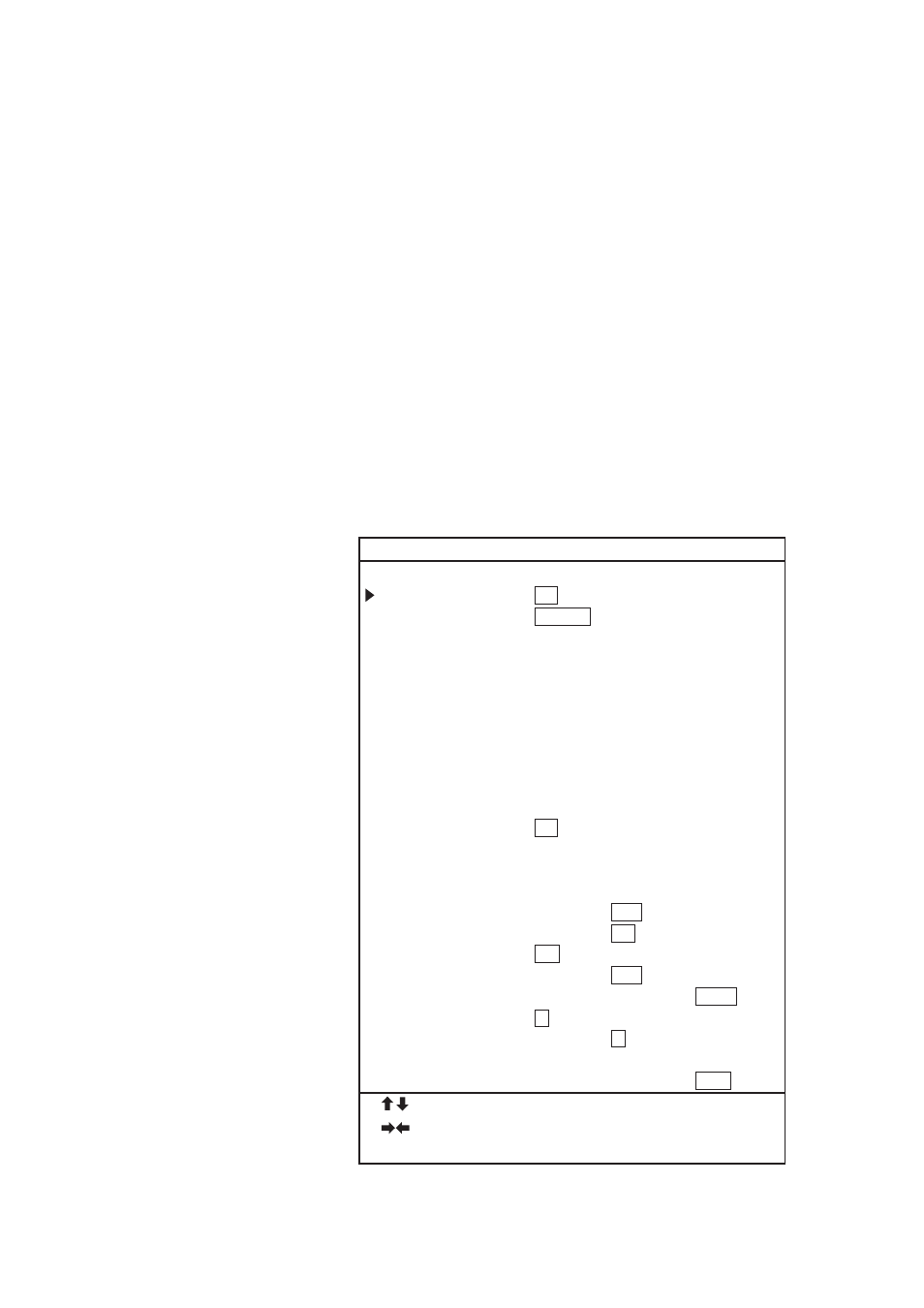
10.2 GPS and DGPS Initial Settings
This section provides the information necessary for entering GPS
initial settings.
1. Press [MENU] and [8].
2. Press [
↑
] to set the cursor on PAGE CHANGE (TO GPS INI-
TIAL SETTINGS). The following display appears.
8 GPS INITIAL SETTINGS
PAGE CHANGE (TO INITIAL SETTINGS)
POSITION FIXING MODE = 2D
3D
2D/3D
GEODETIC DATUM
= WGS-84
WGS-72
TOKYO
NAD
EURO
AUST
MISC
(007)
HDOP THRESHOLD
= 20 (2~99)
TIME DIFFERENCE
= 09:00
LATITUDE
= 34
°
00.
000’
N
LONGITUDE
= 135
°
00.
000’
E
DELTA LATITUDE
= 00.
000’
N
DELTA LONGITUDE
= 00.
000’
E
SMOOTHING
= 00~00
L/L-SPEED (0~99)
ANTENNA HEIGHT
= 005
M
COLD START
= NO
YES
CST SATELLITE NO.
= 07
MIN. ELEVATION ANGLE = 05
°
(5~9)
DESELECT SAT NO.
= – –
D.GPS MODE
= ON
OFF
RTCM VER
= 1.0
2.0
BYTE FORM
= 8-6
8-8
FIRST BIT
= MSB
LSB
PARITY BIT
= EVEN
ODD
NONE
STOP BIT
= 1
2
BIT RATE
= 7
8
BAUD RATES
= 300
600
1200
2400
4800
9600
: SELECT ITEM
: SELECT PARAMETER
PROGRAM NO. : 48501050xx
Figure 10-2 GPS INITIAL SETTINGS menu