Furuno FAR-2807 User Manual
Page 26
26
DANGER HIGHLIGHT
Show/hide danger highlights
OFF, ON
PROHIBITED AREA
DISP
Show/hide prohibited areas.
OFF, ON
BUOY DISPLAY
Show/hide buoys.
OFF, ON
GPS BUOY DISPLAY
Show/hide GPS buoys.
OFF, ON
TARGET TRACK MODE
Select target track color assignment
method.
ALL, INDIVIDUAL
MAP DISPLAY
Show/hide radar map.
OFF, ON
MAP MARK COLOR
Select map mark color
RED, GREEN, BLUE,
YELLOW, LIGHT-BLUE,
PURPLE, WHITE
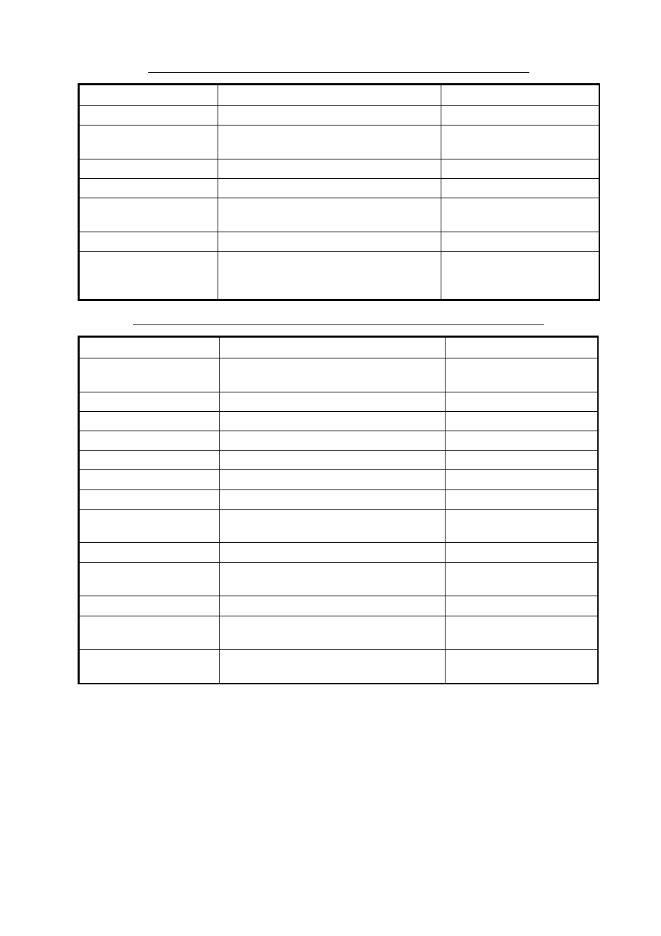
Description of functions available with F1-F3 keys: NAV LINE•WPT category
Item
Function
Settings
NAV LINE DATA
Show/hide nav line data.
OFF, EXTERNAL,
INTERNAL, WAYPOINT
ARRIVAL WPT ALARM
Enable/disable arrival waypoint alarm.
OFF, ON
DISP WPT NO.
Show/hide waypoint number.
OFF, ON
DISP WPT NAME
Show/hide waypoint name
OFF, ON
SKIP NEXT WPT
Skip next waypoint in a route.
TURNING LINE
Show/hide turning line.
OFF, ON, REVISED
DEPTH
Show/hide depth indication.
OFF, m, ft
DEPTH GRAPH SCALE
Select graph scale.
10, 20, 50, 100, 200, 500
(m)
CURRENT
Show/hide current data.
OFF, ON
WIND
Show/hide wind indication; select unit of
measurement.
OFF, m/s, KT
TEMP
Show/hide water temperature data.
OFF, ON
DATE-TIME
Show/hide date-time indication; select
time format.
OFF, UTC, LOCAL
WPT DATA
Show/hide waypoint data; select waypoint
display format.
OFF, RELATIVE, TRUE
Description of functions available with F1-F3 keys: PLOTTER category
Item
Function
Settings