Furuno FAR-2807 User Manual
Page 25
25
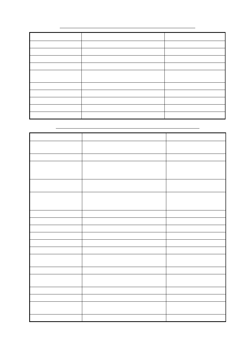
Description of functions available with F1-F3 keys: MARK category
Item
Function
Settings
OWN SHIP MARK
Enable/disable your ship mark.
OFF, ON
STERN MARK
Enable/disable stern mark.
OFF, ON
INDEX LINE
Select number of index lines to display.
1, 2, 3, 6
INDEX LINE MODE
Select index line mode.
HORIZONTAL, VERTICAL
EBL OFFSET BASE
Select offset EBL reference point.
STAB GND, STAB NORTH,
STAB HEAD
EBL1 BEARING
Set bearing reference for EBL1.
RELATIVE, TRUE
EBL2 BEARING
Set bearing reference for EBL2.
RELATIVE, TRUE
CURSOR BEARING
Set bearing reference for cursor.
RELATIVE, TRUE
BARGE MARK
Enable/disable barge marks.
OFF, ON
CURSOR SHAPE
Enable/disable net cursor.
OFF, ON
Description of functions available with F1-F3 keys: PLOTTER category
Item
Function
Settings
CHART COLOR
Select chart color.
GREEN, YELLOW, LIGHT-
BLUE, ORANGE, GRAY
OWN TRACK OFF/ON
HIde/show your ship’s track.
OFF, ON
OWN TRACK COLOR
Select color of your ship’s track.
RED, GREEN, YELLOW,
LIGHT-BLUE, PURPLE,
WHITE
TGT TRACK OFF/ON
Hide/show tracks of targets.
OFF, 10 s, 30 s, 1 min, 3 min,
6 min, 15 min
TGT TRACK COLOR
Select color for target tracks.
RED, GREEN, YELLOW,
LIGHT-BLUE, PURPLE,
WHITE
CURSOR L/L ALIGN
Enable/disable L/L alignment w/cursor.
OFF, ON
MARK ALL ERASE
Erase all marks.
WPT ALL ERASE
Erase all waypoints.
NAV LINE ALL ERASE
Erase all nav lines.
GRID DISPLAY
Show/hide grid.
OFF, L/L
OWN TRACK DISPLAY
Show/hide your track.
OFF, ON
TARGET TRACK
DISPLAY
Show/hide targets’ track.
OFF, ON
MARK DISPLAY
Show/hide all marks.
OFF, ON
LAND DENSITY
DISPLAY
Fill/hollow land on chart.
OFF, ON
PLACE NAME DISPLAY
Show/hide geographic names.
OFF, ON
COAST LINE DISPLAY
Show/hide coastlines.
OFF, ON
CONTOUR LINE
DISPLAY
Show/hide depth contour lines.
OFF, ON, DEPTH(value)
NAV LINE(MAP)
Show/hide nav lines.
OFF/ON