Icon description, Color, White – Clarion NP401 User Manual
Page 20: White redblinking red red gray purple green blue, Eng lis h
E
ng
lis
h
O
w
ne
r’s
M
an
ua
l
20 NP401
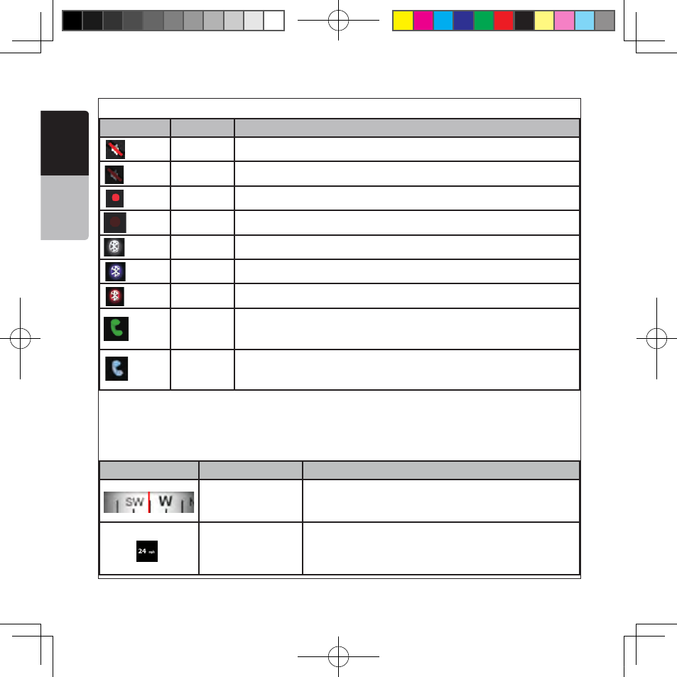
The following symbols appear in the Indicator strip:
Icon
Color Description
Icon
Description
The sound output of Clarion Mobile Map
is muted.
The sound output of Clarion Mobile Map
is enabled.
Clarion Mobile Map records a Track log
when GPS position is available.
Track log recording is disabled.
The Bluetooth radio is switched off.
The Bluetooth radio is tur ned on but no
,
telephone is connected.
There is an error in the Bluetooth connection.
Clarion Mobile Map is connected to a telephone
as a handsfree set via Bluetooth.
A phone call is in progress over the Bluetooth
color
White
White
Redblinking
Red
Red
Gray
Purple
Green
Blue
White
Thesound output of Clarion Mobile Map is muted.
Icon
Description
The sound output of Clarion Mobile Map
is muted.
The sound output of Clarion Mobile Map
is enabled.
Clarion Mobile Map records a Track log
when GPS position is available.
Track log recording is disabled.
The Bluetooth radio is switched off.
The Bluetooth radio is tur ned on but no
,
telephone is connected.
There is an error in the Bluetooth connection.
Clarion Mobile Map is connected to a telephone
as a handsfree set via Bluetooth.
A phone call is in progress over the Bluetooth
color
White
White
Redblinking
Red
Red
Gray
Purple
Green
Blue
White
Thesound output of Clarion Mobile Map is enabled.
Icon
Description
The sound output of Clarion Mobile Map
is muted.
The sound output of Clarion Mobile Map
is enabled.
Clarion Mobile Map records a Track log
when GPS position is available.
Track log recording is disabled.
The Bluetooth radio is switched off.
The Bluetooth radio is tur ned on but no
,
telephone is connected.
There is an error in the Bluetooth connection.
Clarion Mobile Map is connected to a telephone
as a handsfree set via Bluetooth.
A phone call is in progress over the Bluetooth
color
White
White
Redblinking
Red
Red
Gray
Purple
Green
Blue
Red blinking Clarion Mobile Map recordsaTrack logwhen GPS position is available.
Icon
Description
The sound output of Clarion Mobile Map
is muted.
The sound output of Clarion Mobile Map
is enabled.
Clarion Mobile Map records a Track log
when GPS position is available.
Track log recording is disabled.
The Bluetooth radio is switched off.
The Bluetooth radio is tur ned on but no
,
telephone is connected.
There is an error in the Bluetooth connection.
Clarion Mobile Map is connected to a telephone
as a handsfree set via Bluetooth.
A phone call is in progress over the Bluetooth
color
White
White
Redblinking
Red
Red
Gray
Purple
Green
Blue
Red
Tracklog recording isdisabled.
Icon
Description
The sound output of Clarion Mobile Map
is muted.
The sound output of Clarion Mobile Map
is enabled.
Clarion Mobile Map records a Track log
when GPS position is available.
Track log recording is disabled.
The Bluetooth radio is switched off.
The Bluetooth radio is tur ned on but no
,
telephone is connected.
There is an error in the Bluetooth connection.
Clarion Mobile Map is connected to a telephone
as a handsfree set via Bluetooth.
A phone call is in progress over the Bluetooth
color
White
White
Redblinking
Red
Red
Gray
Purple
Green
Blue
Gray
TheBluetooth radio is switched off.
Icon
Description
The sound output of Clarion Mobile Map
is muted.
The sound output of Clarion Mobile Map
is enabled.
Clarion Mobile Map records a Track log
when GPS position is available.
Track log recording is disabled.
The Bluetooth radio is switched off.
The Bluetooth radio is tur ned on but no
,
telephone is connected.
There is an error in the Bluetooth connection.
Clarion Mobile Map is connected to a telephone
as a handsfree set via Bluetooth.
A phone call is in progress over the Bluetooth
color
White
White
Redblinking
Red
Red
Gray
Purple
Green
Blue
Purple
TheBluetooth radio is turnedon but no telephone isconnected.
Icon
Description
The sound output of Clarion Mobile Map
is muted.
The sound output of Clarion Mobile Map
is enabled.
Clarion Mobile Map records a Track log
when GPS position is available.
Track log recording is disabled.
The Bluetooth radio is switched off.
The Bluetooth radio is tur ned on but no
,
telephone is connected.
There is an error in the Bluetooth connection.
Clarion Mobile Map is connected to a telephone
as a handsfree set via Bluetooth.
A phone call is in progress over the Bluetooth
color
White
White
Redblinking
Red
Red
Gray
Purple
Green
Blue
Red
There isan error in theBluetooth connection.
Icon
Description
The sound output of Clarion Mobile Map
is muted.
The sound output of Clarion Mobile Map
is enabled.
Clarion Mobile Map records a Track log
when GPS position is available.
Track log recording is disabled.
The Bluetooth radio is switched off.
The Bluetooth radio is tur ned on but no
,
telephone is connected.
There is an error in the Bluetooth connection.
Clarion Mobile Map is connected to a telephone
as a handsfree set via Bluetooth.
A phone call is in progress over the Bluetooth
color
White
White
Redblinking
Red
Red
Gray
Purple
Green
Blue
Green
Clarion Mobile Map is connected to a telephone as a handsfree set via
Bluetooth
Icon
Description
The sound output of Clarion Mobile Map
is muted.
The sound output of Clarion Mobile Map
is enabled.
Clarion Mobile Map records a Track log
when GPS position is available.
Track log recording is disabled.
The Bluetooth radio is switched off.
The Bluetooth radio is tur ned on but no
,
telephone is connected.
There is an error in the Bluetooth connection.
Clarion Mobile Map is connected to a telephone
as a handsfree set via Bluetooth.
A phone call is in progress over the Bluetooth
color
White
White
Redblinking
Red
Red
Gray
Purple
Green
Blue
Blue
A phone call is in progress over theBluetooth connection.
The following information can be seen in the three data fields shown on the map screen. Tap this area to
open the Trip Information screen where you can select which values to be shown in these three fields.
When there is no active route, these fields show the following information: current speed, compass and the
current time of day.
Icon
Type
More information
Compass
Shows the direction of your heading both when the map
is automatically rotated (3D) and when the map is always
facing North (2D).
Speed information
There are speed values that can be shown:
• Current speed
• Speed limit on the current road
NP401 OM_100920_EN.indd 20
2011-1-6 16:10:53