Bts master™ base station analyzer features, Coverage mapping – Atec Anritsu-MT8221B User Manual
Page 8
8
BTS Master™ Base Station Analyzer Features
Coverage Mapping
(Option 0431)
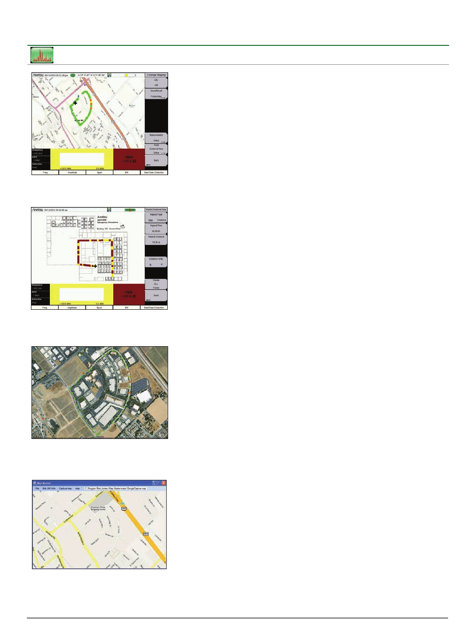
On-screen Outdoor Coverage Mapping
Enables a maintenance technician to make low cost
coverage measurements to quickly verify coverage
around a base station site.
On-screen Indoor Coverage Mapping
Import an image of an office floor plan and use the
start-walk-stop method to record coverage strength.
Validates coverage for enterprise accounts.
Map Master
™
Map Master is a PC-based program that allows you
to capture maps with GPS coordinates that can be
imported into the instrument via a USB drive.
Plot Coverage on PC-based Map
Once coverage data has been collected on the
instrument, the data can be imported into a mapping
program for further review and reporting.
Coverage Mapping Measurements
Spectrum Analyzer Mode
ACPR
RSSI
Coverage Mapping
There is a growing demand for low cost
coverage mapping solutions. Anritsu’s
Coverage Mapping measurements option
provides wireless service providers, public
safety users, land mobile ratio operators,
and government officials with indoor and
outdoor mapping capabilities.
Outdoor Mapping
With a GPS antenna connected to the
instrument and a valid GPS signal, the
instrument monitors RSSI and ACPR levels
automatically. Using a map created with
Map Master, the instrument displays maps,
the location of the measurement, and a
special color code for the power level.
The refresh rate can be set up in time
(1 sec, minimum) or distance.
The overall amplitude accuracy coupled
with the GPS update rate ensures accurate
and reliable mapping results.
Indoor Mapping
When there is no GPS signal valid,
the BTS Master uses a start-walk-stop
approach to record RSSI and ACPR levels.
You can set the update rate, start location,
and end location and the interpolated
points will be displayed on the map.
Export KML Files
Save files as KML or JPEG. Open KML files
with Google Earth™. When opening up
a pin in Google Earth, center frequency,
detection method, measurement type,
and RBW are shown on screen.
Map Master™
The Map Master program creates maps on
your PC compatible with the BTS Master.
Maps are created by typing in the address
or by converting existing JPEG, TIFF, BMP,
GIF, and PNG files to MAP files. Utilizing the
built-in zoom in and zoom out features, it is
easy to create maps of the desired location
on your PC and transfer to the instrument
with a USB flash drive. Map Master also
includes a GPS editor for inputting latitude
and longitude information of maps from
different formats.