Garmin GPSMAP 5215 User Manual
Page 20
16
GPSMAP
®
4000/5000 Series Owner’s Manual
Charts and 3D Chart Views
Heading and Projected Course of Activated AIS Targets
When heading and course over ground information are provided by an activated AIS target, the heading of the
target appears on a chart as a solid line attached to the AIS target symbol. A heading line does not appear on a
3D chart view.
The projected course of an activated AIS target appears as a dashed line on a chart or a 3D chart view. The
length of the projected course line is based on the value of the projected heading setting (
activated AIS target is not transmitting speed information, or if the vessel is not moving, a projected course
line does not appear. Changes in the speed, the course over ground, or the rate-of-turn information transmitted
by the vessel can impact the calculation of the projected course line.
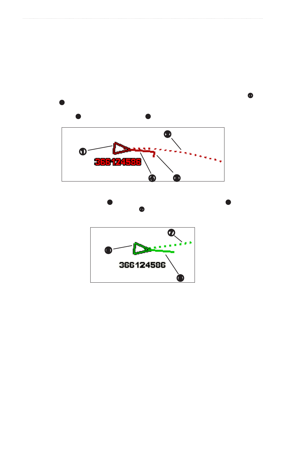
When course over ground, heading, and rate of turn information are provided by an activated AIS target
➊
, the
projected course
➋
of the target is calculated based on the course over ground and the rate of turn information.
The direction in which the target is turning, which is also based on the rate of turn information, is indicated by
the direction of the barb
➌
at the end of the heading line
➍
. The length of the barb does not change.
➍
➌
➋
➊
Target with Projected Course, Heading, and Direction of Turn
When course over ground and heading
➎
information are provided by an activated AIS target
➏
, but rate of
turn information is not provided, the projected course
➐
of the target is calculated based on the course over
ground information.
➎
➐
➏
Target with Projected Course and Heading
Turning Off AIS Reception
AIS signal reception is turned on by default.
From the Home screen, select Configure > other Vessels > AiS > off.
All AIS functionality on all charts and on all 3D chart views is disabled. This includes AIS vessel targeting
and tracking, collision alarms that result from AIS vessel targeting and tracking, and the display of
information about AIS vessels.
Showing AIS and MARPA Vessels on a Chart or on a 3D Chart View
AIS requires the use of an external AIS device and active transponder signals from other vessels. Mini
Automatic Radar Plotting Aid (MARPA) functionality works with radar (
You can configure how other vessels appear on a chart or on a 3D chart view. The display range and MARPA
settings configured for one chart or one 3D chart view are applied only to that chart or to that 3D chart view.
The details, projected heading, and trails settings configured for one chart or one 3D chart view are applied to
all charts and to all 3D chart views.
Note: The Mariner’s Eye 3D chart view is available if you use a BlueChart g2 Vision data card. The Fishing
chart is available if you use a BlueChart g2 Vision data card or a BlueChart g2 Data card, or if your built-in
map supports Fishing Charts.