Real-time mapper buttons – TeeJet SmartPad II Quick Start Guide User Manual
Page 10
Bulletin 98-01122
R3
10
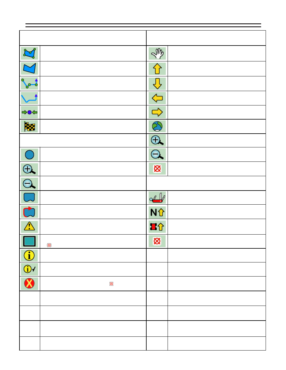
Locked Information - When this button is displayed, it mean that the
Information Button was pressed. Information stays displayed in the
Information Window while moving to other buttons in the button bar.
Zoom In - When pressed this button decreases area displayed in the
view page. There are a total of 5 zoom levels.
Zoom Out - When pressed this button increases area displayed in the
view page. There are a total of 5 zoom levels.
Map Field Boundary Off - When this button is displayed, the field
boundary is not being mapped. When pressed this button changes to
the Map Field Boundary On Button.
Map Field Boundary ON - When this button is displayed, the field
boundary is being mapped. When pressed this button changes to the
Map Field Boundary Off Button.
Mark Point - This is the point map object button. When pressed, a
pointis placed at the vehicle location. This button is a result of the Data
Setup - Map Object menu item.
Mark Hazard - This is the hazard map object button. When pressed, a
hazard placed at the vehicle location. This button is a result of the Data
Setup - Map Object menu item.
Full Screen - When Pressed, the entire view page space is replaced by
the map window. This is useful to see more of the vehicle trajectory. Press
exit to return to the normal view page.
Information - When this button is highlighted, information is displayed
in the information window and on the screen.
Exit - When pressed, the software exits out of real-time process and
returns to the Start Guidance page. Pressing the key automatically
highlights this button.
Zoom In - When pressed this button decreases area displayed in
the view page. There are a total of 5 zoom levels.
Zoom Out - When pressed this button increases area displayed in
the view page. There are a total of 5 zoom levels.
REAL-TIME ZOOM AND PAN
REAL-TIME OPTIONS MENU
North Up View - This display option keeps North pointing to the
top of the view page. When pressed, this button changes to the
COG View button.
Course on Ground (COG) View - This display option keeps the vehicle
stationary in the view page with the heading (course) of the vehicle
pointing to the top of the view page. When pressed, this button
changes to the North Up View button.
Option Menu - When pressed, the real-time display options are
displayed. The options are listed below.
Zoom Pan Mode - When pressed this button will enter into Pan
mode. The buttons below will appear and can be used to pan the
screen Up, Down, Left, and Right.
Pan Up - When pressed this button will scroll to the collected data
at the Top of the screen.
Pan Down - When pressed this button will scroll to the collected
data at the Bottom of the screen.
Pan Left - When pressed this button will scroll to the collected
data on the Left side of the screen.
Pan Right - When pressed this button will scroll to the collected
data on the Right side of the screen.
Snap - When pressed the screen will zoom out to its fullest extent
allowing view of the entire working area.
Exit Pan Mode - When pressed Pan Mode is exited and the Zoom
Pan Mode button will be highlighted.
Exit Options Menu - When pressed the Option Menu is exited and
the Option Menu button will be highlighted.
REAL-TIME MAP OBJECT BUTTONS
Polygon Mark - Used to map or locate features that can be represented
by a closed shape made of discrete points. When pressed the Map Object
buttons change to Mark Polygon Point button. Press to mark a point along
the polygon perimeter. When finished press the Finish Flag button.
Mark Polygon/Polyline Point - Used to mark points only when Polygon
Mark or Polyline Mark button is selected. This button goes away after the
Finish Flag button is selected.
REAL-TIME MAPPER DEFAULT BUTTONS
Polygon Stream - Used to map or locate features that can be represented
by a closed shape made up of streaming points.
When pressed the Map
Object buttons changes to the Finish Flag button. Press the Finish Flag to
close the polygon.
Polyline Mark - Used to map or locate features that can be represented by a
line of discrete points. When pressed the Map Object buttons change to
Mark Polyline Point button. Press to mark a point along the polyline. When
finished press the Finish Flag button.
Polyline Stream - Used to map or locate features that can be represented
by a line of streaming points.
When pressed the Map Object buttons
changes to the Finish Flag button. Press the the Finish Flag to close the polygon.
Finish Flag - Used to exit out or close Map Object operations. When
pressed all Map Object buttons appear.
REAL-TIME MAPPER BUTTONS