Operating maps -18, How to view map screen -18 – NISSAN 2010 Maxima - Navigation System Owner's Manual User Manual
Page 25
Black plate (26,1)
Model "08NJ-N" EDITED: 2010/ 5/ 14
HOW TO VIEW MAP SCREEN
The navigation system displays various informa-
tion on the map screen.
Screen information
*
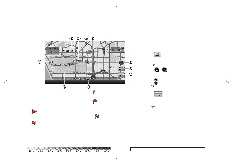
1
Vehicle icon:
Indicates the current vehicle location and
the direction of travel.
*
2
Starting point:
Displays the vehicle location, with which the
route is set, as the starting point.
*
3
Guide point:
Indicates a guide point on the route.
*
4
Waypoint:
Displays locations between the starting
point and the destination. A maximum of 5
waypoints can be set.
*
5
Destination:
Indicates the destination location of the
route guidance.
When you reach your destination, the
address will be displayed on the map
screen.
*
6
Suggested route:
Appears in bold yellow during route gui-
dance.
*
7
Map Menu icon:
Touch the icon to display the Map Menu
screen.
*
8
/
Direction indicator:
Indicates the directional setting of the map.
Touch the icon to change the setting.
: North always pointing up.
: Traveling direction always pointing up.
“SETTING MAP ORIENTATION” (page 3-
15)
*
9
Scale indicator:
Indicates the scale of the map.
Touch the icon to display the scale bar. This
allows the map scale to be adjusted.
“OPERATING WITH TOUCH OPERA-
TION” (page 3-10)
*
10
Street name:
Displays the name of the street that the
vehicle is currently driving on.
OPERATING MAPS
2-18
Getting started