Map summary, Search along – Telenav for Verizon Supported Devices: v5.1 for BlackBerry Storm User Manual
Page 35
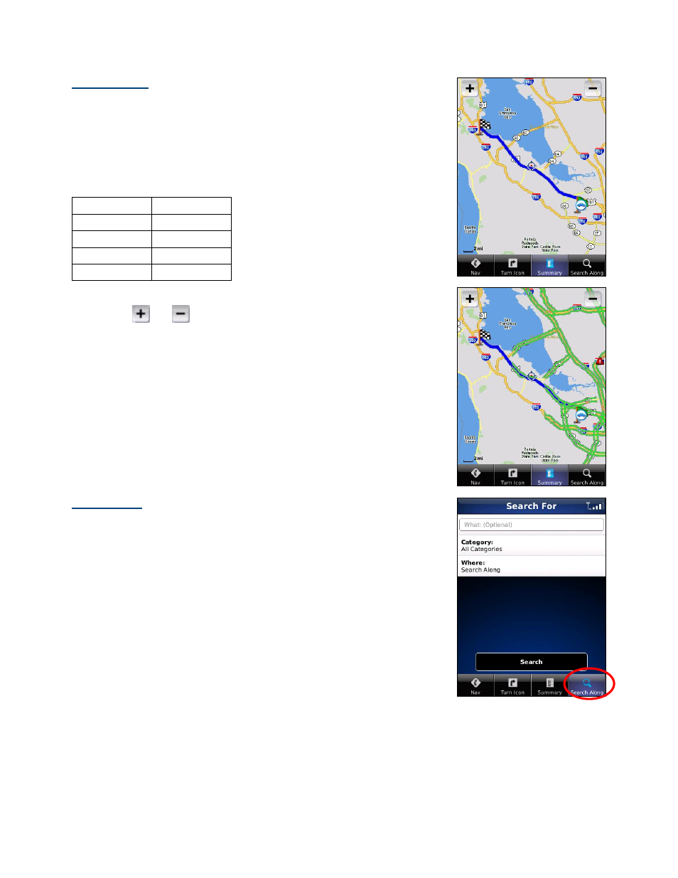
Map Summary
The entire route from your starting location to your destination is drawn on a
map, complete with the latest traffic alerts and traffic flow information. The route
is displayed as a blue line connecting the Start and Finish flags.
Highways and major roads with traffic flow information are color-coded by speed
in each direction of travel:
Speed Road
Color
> 50 mph
Green
30 – 50 mph
Yellow
< 30 mph
Red
Unknown Grey
1. Press
the
Menu key to choose “Hide Traffic” or “Show Traffic.”
2. Tap and
to zoom in and out of the map. Use your finger to pan
the map.
Search Along
Use the Directory to find the desired locations along your navigation route. For
example, find every Mexican restaurant on your route between San Francisco
and Sacramento. This also displays how many miles off your route each
restaurant is. Select a restaurant from the Search Along list to get driving
directions from your current location to the restaurant.
© TELENAV, INC. 2003-2009
PAGE 35 OF 56
- Scout v1.10 for iPhone (open market) (69 pages)
- Scout v1.9 for iPhone (open market) (70 pages)
- Scout v1.8 for iPhone (open market) (67 pages)
- Scout v1.7 for iPhone (open market) (65 pages)
- Scout v1.6 for iPhone (open market) (65 pages)
- Scout v1.5 for iPhone (open market) (120 pages)
- Scout v1.2 for iPhone (open market) (131 pages)
- Scout v1.1 for iPhone (open market) (129 pages)
- Scout v1.0 for iPhone (open market) (112 pages)
- Scout v1.4 for Android (75 pages)
- Scout v1.3 for Android (85 pages)
- Scout v1.2 for Android (87 pages)
- Scout v1.2 for Windows for T-Mobile (70 pages)
- Scout v1.0 for Windows for T-Mobile (74 pages)
- for Unlocked Supported Devices: v5.1 for HTC Advantage (6 pages)
- for Unlocked Supported Devices: Mobile Office - HTC Shift (136 pages)
- for Verizon Supported Devices: v6.2 for BlackBerry (64 pages)
- for Verizon Supported Devices: v6.2 for Android phones (57 pages)
- for Verizon Supported Devices: v5.5 for BlackBerry Storm (64 pages)
- for Verizon Supported Devices: v5.5 for BlackBerry Tour (68 pages)
- for Verizon Supported Devices: v5.1 for BlackBerry 8830 Users Guide (52 pages)
- for Verizon Supported Devices: v5.1 for BlackBerry 8830 Quick Start Guide (3 pages)
- for Verizon Supported Devices: v5.1 for BlackBerry Tour (5 pages)
- for Verizon Supported Devices: v5.0 for Palm Treo 700p (43 pages)
- for Verizon Supported Devices: v4.1 for Palm Treo 650 (30 pages)
- for Verizon Supported Devices: v4.1 for Palm Treo 700w (29 pages)
- for Verizon Supported Devices: v4.1 for Verizon XV-6700 (31 pages)
- for T-Mobile Supported Devices: v7.1 for Android phones (94 pages)
- for T-Mobile Supported Devices: v6.2 for BlackBerry devices (69 pages)
- for T-Mobile Supported Devices: v6.2 for Android phones (61 pages)
- for T-Mobile Supported Devices: v6.0 for BlackBerry smartphones (58 pages)
- for T-Mobile Supported Devices: v5.8 for Android phones (71 pages)
- for Boost Mobile Supported Devices: v5.8 for BlackBerry smartphones (73 pages)
- for T-Mobile Supported Devices: v5.8 for Windows Phone 7 devices (66 pages)
- for T-Mobile Supported Devices: v5.76 for J2ME devices (71 pages)
- for T-Mobile Supported Devices: v5.5 for Windows Mobile HTC devices (64 pages)
- for T-Mobile Supported Devices: v5.5 for Windows Mobile smartphones (3 pages)
- for T-Mobile Supported Devices: v5.5 for Windows Mobile professional (4 pages)
- for T-Mobile Supported Devices: v5.5 for Android devices (71 pages)
- for T-Mobile Supported Devices: v5.5 for T-Mobile Sidekick LX (57 pages)
- for T-Mobile Supported Devices: v5.2 for J2ME touch screen devices (70 pages)
- for T-Mobile Supported Devices: v5.2 for Samsung T929 (69 pages)
- for T-Mobile Supported Devices: v5.2 for Samsung T919 Users Guide (60 pages)
- for T-Mobile Supported Devices: v5.2 for Samsung T919 Quick Start Guide (4 pages)