Viewing tidal information – Garmin GPSMAP 2108 User Manual
Page 14
10
GPSMAP
®
2008/2108 Owner’s Manual
U
sing
C
harTs
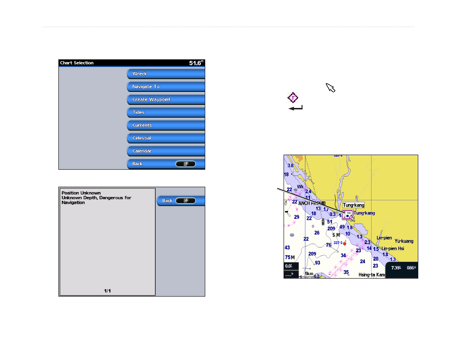
2. Select the item. If more than one item is in the
area, select
Review
, and then select the item.
Viewing Tidal Information
Tidal station appears on the chart with a detailed
information for users’ reference. You can view an in-
depth description.
1. Use the map pointer ( ) to highlight a tide
station icon ( ),
and press
.
2. Select Tidal Name(Tung-Kang) and you can
view detailed tidal
information.
Relevant tide level
(when animated)
For more information about tides, see
page 22
.
This manual is related to the following products:
See also other documents in the category Garmin Sports and recreation:
- GMR 406 (26 pages)
- 340c (2 pages)
- GHP 10 (48 pages)
- GMR 1204 (14 pages)
- GMR24 Hd (12 pages)
- 190-00864-01 (24 pages)
- GFS 10 (24 pages)
- GMR 40 (32 pages)
- GMI 10 (8 pages)
- GMI 10 (20 pages)
- 240 (50 pages)
- Hiking Equipment (2 pages)
- GHS 10i (10 pages)
- G2 (24 pages)
- 100 BLUE (50 pages)
- GSD-20 (12 pages)
- GTX 320 ATC (24 pages)
- 80 (2 pages)
- GMR 41 (32 pages)
- 160 BLUE (50 pages)
- 250C (1 page)
- VHF 200 (10 pages)
- GMR 41 (26 pages)
- 160 (50 pages)
- Gxm 51 (10 pages)
- 160C (32 pages)
- Nuvi 900 (16 pages)
- GSD22 (8 pages)
- 90/140 (32 pages)
- VHF 200 (2 pages)
- Ghc 10 (28 pages)
- GSD 22 (10 pages)
- GPSMAP 3010C (2 pages)
- GPSMAP 3010C (130 pages)
- GPSMAP 76CSx (64 pages)
- GPSMAP 76CSx (2 pages)
- GPSMAP 76S (18 pages)
- GPSMAP 76S (76 pages)
- GPSMAP 172C (110 pages)
- GPSMAP 3005C (124 pages)
- GPSMAP 3005C (2 pages)
- GPSMAP 276C (2 pages)
- GTX 328 (10 pages)
- GPSMAP 526s (84 pages)